The First Public Report of the National Risk Profile
Erratum
Date: January 2024
Location(s): 5.5.1; 5.5.3; 5.5.4; 5.5.5; Table 9c; 6.5.1; 6.5.3; 6.5.4; 6.5.5.
Revision(s): Typographical errors corrected in some impact category text descriptions for alignment with numeric impact ratings. Numeric total for flood social impact score corrected from 1.5–3.0 to 2.5–5.0.
Rationale for the revision: Internal review revealed required edits.

Table of contents
- Purpose of the National Risk Profile
- Acknowledgements
- 1. Executive summary
- 2. Background and purpose
- 2.1. What is emergency management and why do we need it?
- 2.2. Who is responsible for emergency management?
- 2.3. The Emergency Management Strategy for Canada: Toward a Resilient 2030
- 2.4. The National Risk Profile: A tool to implement the Emergency Management Strategy
- 2.5. Why do Canadians need to know about disaster risk?
- 2.6. Risk perception, awareness and disaster preparedness
- 2.7. An evolving disaster risk environment: risk drivers
- 2.8. Economic impacts of disasters
- 3. NRP process: Building the evidence base
- 4. Hazard: Earthquakes
- 4.1. Understanding earthquakes in Canada
- 4.2. Earthquake exposure and likelihood – who and what is at risk?
- 4.3. Understanding differential impacts of earthquakes – who is most vulnerable?
- 4.4. Understanding risk drivers – how is earthquake risk changing?
- 4.5. NRP earthquake risk assessments
- 4.6. Earthquake capability assessments
- 4.7. Moving forward
- 5. Hazard: Wildland fires
- 5.1. Understanding wildland fires in Canada – how does it impact us?
- 5.2. Impacts of wildland fire
- 5.3. Understanding wildland fire risk – who and what is at risk?
- 5.4. Understanding risk drivers – how is wildland fire risk changing?
- 5.5. NRP wildland fire risk assessments
- 5.6. Wildland fire capability assessment highlights
- 5.7. Moving forward
- 6. Hazard: Floods
- 6.1. Flood risk management
- 6.2. Flood exposure and likelihood – who and what is at risk?
- 6.3. Understanding differential impacts of floods – who is most vulnerable?
- 6.4. Understanding risk drivers – how is flood risk changing?
- 6.5. NRP flood risk assessment
- 6.6. Flood capability assessment highlights
- 6.7. Moving forward
- 7. Pandemics lens
- 8. Summary of evidence and key findings
- 9. Looking to the future
- 10. Conclusion
- 11. List of Annexes
Purpose of the National Risk Profile
The National Risk Profile (NRP) is a federal government initiative. The NRP was developed with provincial, territorial, and expert stakeholder input. It reflects information and findings compiled by the Government of Canada. The final report was drafted by the Government of Canada.
The NRP is Canada's first strategic, national-level risk assessment. This report is based on input and evidence from whole-of-society stakeholders across Canada, and provides a foundation for understanding disaster risk from the three costliest hazards facing Canadians: earthquakes, wildland fire, and floods. It aims to broaden public awareness of disaster risk, identify gaps in the Canadian emergency management system at a national level and provide evidence to support existing federal risk assessment and climate change adaptation efforts. This evidence base can help reduce disaster risk and increase resilience for everyone in Canada.
Given the ongoing COVID-19 pandemic, this report also contains a chapter on pandemics. However, it is important to note that this report does not analyze pandemics as a distinct hazard. Pandemics are examined as a contextual factor that affect disaster risk and response. Observations and lessons learned thus far for emergency management from the COVID-19 pandemic are also presented. However, it does not serve as a review or assessment of the Government's response to the pandemic as this remains a continuous event for which the response is ongoing.
The NRP is not a policy document nor does it include any proposed funding towards any of the gaps and issues identified. Rather, it presents all levels of government, stakeholders and the general public with national evidence on Canada's disaster risk and gaps in the emergency management system.
Acknowledgements
This report would not have been possible without the support and commitment from whole-of-society partners including federal departments and agencies, provinces and territories, municipalities, Indigenous organizations and communities, as well as the academic, private, volunteer, and non-governmental sectors from across different communities living within Canada. These participants supported risk and capability assessments in order to create a pan-Canadian picture of the hazard risks facing Canadians and core capabilities across all sectors of society. Their input and collaboration on various risk impact categories and on baseline and target capability assessments provides a critical foundation for this body of work.
We gratefully acknowledge the input from Indigenous communities and individuals whose perspectives on these topics help to shape the findings, and thank Cambium Indigenous Professional Services for their assistance in this engagement.
Additionally, we would like to thank key members and the co-chair of the National Adaptation Strategy's Disaster Resilience and Security Advisory Table for their invaluable contributions to this report.
1 Executive Summary
1.1 Introduction
As the frequency and intensity of natural hazards across Canada increases, the importance of promoting and building resilience becomes evident. By taking a systematic, evidence-based, all-hazards approach to emergency management, this first public report of the National Risk Profile (NRP) seeks to lay a foundation for understanding disaster risk in three key areas: earthquakes, wildland fires, and floods.
Given the increasing impacts and challenges associated with climate change, capturing a national picture of disaster risk requires coordination and a common approach to integrate information across all sectors of society. Therefore, this report is based on input and evidence from whole-of-society stakeholders across Canada, and identifies current disaster risks and capability gaps in today's national emergency management system. This knowledge can help identify the interventions to reduce these risks for everyone in Canada, including addressing the disproportionate impacts of disasters on vulnerable populations.
To capture the full range of experiences, federal departments and agencies, provinces and territories, municipalities, Indigenous organizations and communities, as well as the academic, private, volunteer, and non-governmental sectors, from across different Canadian communities took part in the NRP research process. This report also includes summary targeted findings and considerations regarding Indigenous communities and emergency management, derived from an externally-facilitated engagement process led by Cambium Indigenous Professional Services. Coupled with existing knowledge and initiatives being undertaken across the federal government, this report is the first in Canada to provide a national overview of disaster risk and capabilities. By doing so, this report adopts a forward looking, all-hazards approach to inform future emergency management capabilities and build national resilience.
The report starts with an outline of how emergency management is structured in Canada, across various orders of government. Responsibility also lies with individuals who need to take steps to prepare for these disasters. Emergency management activities are governed by various legislation, plans and frameworks, which inform the approaches and responses in this space. Given the disproportionate impacts of disasters on their communities, emergency management can differ for Indigenous peoples. This results in different types of programming to respond to their unique needs.
As recent events like Hurricane Fiona and others demonstrate, building national resilience to these events is vital. In addition to the growing frequency and impacts of these events, recent data indicates that Canadians, on average, lack disaster risk awareness and knowledge, which may hinder their ability to prepare well for emergencies.
Given this reality, this public report serves as a communication tool for increasing disaster risk awareness, preparedness, readiness and response. This is a new endeavor for Canada, and supports international commitments under the United Nations Sendai Framework for Disaster Risk Reduction and work already being undertaken by like-minded countries in developing similar risk assessments. This report is a key deliverable under Canada's Emergency Management Strategy and supports whole-of-society collaboration and governance to uphold disaster resilience.
The report then looks at why Canadians need to know about disaster risk. Findings in this report demonstrate the wide-reaching impacts of disasters, from heavy financial burdens for governments and individuals alike, to long-lasting psychosocial effects and more intangible losses, such as harm to priceless cultural heritage. Many disasters cause business disruption and closures, impacts to transportation networks, and/or damage to infrastructure. The data in this report clearly demonstrates that the costs of disasters, whether economic or social, government or individual, will continue to rise for both the public and private sectors. The increasing impacts of climate change, Canada's changing demographics, and other risk drivers are also given attention.
Although these are major, growing challenges, the report speaks to how investments in adaptation have proven benefits to help mitigate and reduce the costs due to a warmer climate. Disaster mitigation and climate change adaptation projects have a proven return on investment.
The NRP is one piece in a series of federal initiatives that advance disaster risk reduction. These include various efforts to support climate change adaptation at the national level, as well as system wide changes that support improvements to emergency management approaches and response. The evidence gathered through the NRP is a foundational piece supporting these initiatives. It is a tool that will help integrate climate change adaptation into emergency management and inform decisions and investments that support overall national resilience.
In order to develop a robust evidence base, the NRP uses proven methods and follows a rigorous research process. Whole-of-society stakeholders with expertise in disaster risk reduction, emergency management and climate change adaptation, were engaged in risk and capability assessments. These assessments provide a picture of the disaster risks facing Canada and the existing capabilities in our emergency management system to address them. This knowledge can help identify interventions to reduce these risks for everyone in Canada.
This first report focuses on earthquakes, floods and wildland fires given that they are the costliest hazards for Canada. Representative scenarios were developed for each hazard and were assessed by stakeholders to improve our understanding of potential impacts, as well as the emergency management capabilities available to prepare for, respond to, and recover from these events. Stakeholders also looked at how disaster management activities are influenced by public health emergencies like the COVID-19 pandemic. Overall, the risk and capability assessments helped inform how we can further our resilience to these events, as well as refine our methodology for the future as we learn from this initial round of assessments.
1.2 Key Findings
Each chapter in this report provides a focused analysis on the three areas noted above. Overall, the structure of each chapter includes an overview of the hazard itself, costs and losses due to the hazard, a look at who is at risk, and initial findings from national stakeholders on the impacts these events would have for people, the economy, the environment, the government, as well as potential social impacts (e.g., reduced social cohesion). The evidence also assesses the ability of Canadian communities and authorities to prepare for these events, adapt to changing risk environments, and recover from disruptions.
In addition to the hazard-specific findings outlined in each chapter, impacts for how particular groups of people experience these disasters, including for those populations at higher risk, have been considered. For example, many Indigenous communities face increasing risks to climate change related hazards because of a variety of factors, including community size, socio-economic conditions, limited access to emergency management resources, and infrastructure gaps. Further, children, the elderly, persons living with disability and those with preexisting medical conditions, among others, have heightened risks of experiencing the negative physical and psychosocial impacts of the disasters examined here. Given these impacts, this report highlights the importance of specialized approaches to emergency management to ensure that no Canadian is left behind.
The key findings of the report are summarized below:
1.2.1 Earthquakes
- 1. While the majority of earthquakes in Canada are minor and cannot be felt, a major earthquake would be very costly.
- Data indicates, for example, that a severe earthquake in British Columbia—9.0-magnitude—could result in $75 billion in losses and a similarly probable event in the Quebec City-Montreal-Ottawa corridor could result in $61 billion in losses.
- 2. Stakeholders identified hazard monitoring, early warning and the incorporation of Indigenous knowledge as gaps in the Canadian emergency management system related to addressing earthquakes.
- These areas with gaps were identified based on a systematic assessment of the capabilities on the Canadian Core Capabilities ListFootnote 1.
- 3. Better information on earthquake risk, and greater access to information on how to prepare for earthquakes, are required.
- Various initiatives are underway across the federal government to reduce earthquake risk including actions on mitigation, community planning, and providing a better picture of what a future earthquake would look like.
1.2.2 Wildland Fires
- 4. The impacts of climate change are causing longer and more intense fire seasons, with costs to the economy in the billions.
- Efforts are being made to improve Canadians' awareness on how to face wildland fires in their communities, and to help build more resilient infrastructure that can stand up to the effects of wildland fire.
- 5. There remain gaps in public awareness of wildland fires as well as in our ability to respond to wildland fires at the national level.
- There is also inadequate inclusion of Indigenous knowledge in wildland fire management and response.
- 6. Work is being undertaken to help identify the landscapes and communities that are at greatest fire risk, and which mitigation investments would be most effective.
- This includes an improved understanding of fire processes and the development of operational tools to help make informed decisions on wildland fire risk.
1.2.3 Floods
- 7. Flooding is Canada's most costly and frequent hazard, causing economic, social and environmental burdens for the whole of society.
- Climate change is likely to increase the frequency and severity of flooding in many areas of Canada, which will further exacerbate its impacts.
- 8. There are gaps in coordination to address flood risk across orders of government, a patchwork of flood data and information available to help mitigate flood risk, and again, low levels of awareness amongst Canadians.
- A significant proportion of the population is exposed to flooding, and greater information on flood risk, including forecasts and alerts, will help all levels of government mitigate the effects of flooding.
1.2.4 Looking at emergency management through a "pandemics lens”
Given the impacts of the COVID-19 pandemic on Canadians and the Canadian emergency management system, the pandemics lens chapter focuses on how pandemics and public health emergencies interact with, and affect, other hazards and disasters. It does not provide analysis of pandemics as a distinct hazard, but rather shares “pandemic lens” considerations that emerged from the risk assessments for earthquakes, wildland fires and floods as well as a summary of observations and considerations for future pandemics.
- 9. The COVID-19 pandemic has shed light on deeply entrenched health, social and economic inequities that exist in Canada, specifically for populations already experiencing poorer health outcomes.
- These vulnerable populations face pandemics at a greater risk of illness and death and many carry a greater burden of public health measures.
- 10. Decreased operational capacity during a pandemic has significant impacts on emergency response.
- For example, hospital capacity issues are magnified when a disaster happens during a pandemic (concurrent events), and evacuations after a disaster pose challenges for limiting pandemic exposure and spread.
- 11. Partnerships amongst all levels of government, and attention to equitable measures to support resilience across Canada, will be key.
- The NRP contributes to the growing evidence base on the impacts of pandemics on Canadians as it relates to emergency management. As our knowledge of pandemics evolves, so too will our policies, practices, and approaches across all response areas, for all hazards.
1.2.5 Cross-cutting findings
The cross-cutting findings of this report highlight emergency management gaps that were identified across the risk assessments for earthquakes, wildland fires and floods. They fall under three broad categories: emergency management governance and coordination, disaster recovery and resilience, and empowering Canadians to be prepared for disasters.
- 12. Emergency management governance and coordination:
- To ensure the resilience of Canadian society to disasters and the impacts of climate change, emergency management and disaster risk reduction activities must be coordinated, proactive and efficient. There remain alignment gaps between different jurisdictions in terms of emergency management approaches and programming. There is also room to further integrate climate change adaptation into emergency management as well as address information sharing gaps between the health and emergency management systems.
- 13. Disaster recovery and resilience:
- We know that disasters and climate change are having significant mental health impacts for Canadians, but there is a need for better data on these broad psychosocial consequences. Low levels of insurance uptake in high-risk earthquake and flood areas as well as inadequate risk reduction measures—such as retrofit programs and natural infrastructure solutions—were also identified as important gaps.
- 14. Empowering Canadians to be prepared for disasters:
- There is a need to raise awareness of disaster risk among Canadians to create a culture of disaster preparedness. Specific areas where gaps exist include: access to information on risks from particular hazards and how to prepare for them, robust community disaster response capabilities and the integration of Indigenous knowledge in emergency management activities.
1.3 Looking Ahead
This report is a first step towards understanding disaster risk in Canada from a national perspective that builds upon existing knowledge and stakeholder expertise. This report does not propose policy solutions, but will serve as an evolving, foundational evidence base and tool to increase national disaster risk awareness and support a whole-of-society approach to emergency management. In the future, the NRP will expand to consider other disaster risks, including a focus on human-induced hazards that could significantly impact Canada's national security and economic prosperity, such as acts of terrorism or cyber-attacks.
The evidence base supporting the NRP will continue to grow and evolve this year and into the future, with the goal of providing more national-level analysis and information on gaps and challenges in the Canadian emergency management system, so that effective decision-making can be supported with strong evidence. As new data is gathered and findings developed, the NRP methodology will be refined and improved to capture the impacts of a broader range of disasters and to further improve understanding of the capabilities to prevent, mitigate, respond to, and recover from these events.
2. Background and Purpose
2.1 What is emergency management and why do we need it?
Emergencies and disasters have wide-ranging impacts on the lives and livelihoods of Canadians. This section provides an overview of emergency management in Canada and the role of the National Risk Profile (NRP) in protecting Canadians and building national resilience. The findings of the NRP provide a picture of the risks facing Canada and shed light on how the current emergency management system is able to reduce and cope with disaster risks. In the long term, this evidence base may help inform whole of society actions to support effective decision-making and investments for ensuring a safer, more resilient Canada.
When a hazardFootnote 2 affects Canadians to the extent that the impact exceeds or overwhelms a community's ability to cope, and may cause serious harm to safety, health, property or the environment, the event becomes known as a disaster. Emergency management is how we manage, mitigate, prepare, respond to, and recover from emergencies and disasters.
Canada borders three oceans, stretches across six time zones, and consists of an array of meteorologically influencing mountains, plains, forests, and tundra. Severe weather and geological events that can lead to a disaster are a constant reality for Canadians because Canada experiences diverse weather across a range of natural environments in a massive and seismically active landscape. The natural and built environments experience weather that ranges from Arctic to moderate, from seemingly endless rains to drought, from frigid cold to deadly heat waves.
Canada has been impacted by a wide range of disasters over the course of its history, most of which have been induced by natural hazards. Over the last 25 years, there has been a significant increase in the number of these disasters dating back to an influx of events in the mid-1990s. (e.g., the 1996 Saguenay River flood, the 1997 Red River flood, and the 1998 Ice Storm in Eastern Canada). Furthermore, we have also seen a notable increase in the scale of disasters over the last ten years, such as the 2011 Slave Lake wildland fire, the 2013 Toronto and Calgary pluvial floods, the 2016 Fort McMurray wildland fire and the respective 2017 and 2021 British Columbia wildland fire events, floods and landslides. ReportingFootnote 3 by the Insurance Bureau of Canada shows how various disasters across Canada in 2022 made it the third highest year for uninsured losses in Canadian history ($3.12 billion) including topping total insured losses for 2021 ($2.48 billion).Footnote 4 Many of these events disproportionately impact groups such as Indigenous peoples, women, children, 2SLGBTQIA+Footnote 5, the elderly and persons with a disability, amongst others. Climate change is one of several key risk drivers attributed to the increasing frequency and severity of disasters.Footnote 6
Canada is also at risk of experiencing other types of hazards. The COVID-19 pandemic is a poignant example of how biological hazards can have devastating consequences.
2.2 Who is responsible for emergency management?
Since 2007, federal, provincial and territorial collaboration in emergency management has been guided by the Emergency Management Framework for CanadaFootnote 7 which aims to guide and strengthen the way governments and partners assess risks and work together to prevent, mitigate, prepare for, respond to, and recover from the threats and hazards that pose the greatest risk to Canadians.
Local authorities and individual citizens have a responsibility to be prepared for disasters, and contribute to their community's ability to respond to an emergency. Since disasters most often occur on a local scale, the first response to an emergency is almost always conducted by local or provincial and territorial authorities. Every province has its own unique emergency management structure, including how to engage federal support in the event of an emergency. Many serious situations are dealt with by local or provincial authorities in accordance with provincial emergency management or other relevant legislation and policies. Should provincial, territorial or Indigenous governments require resources beyond their capacity to cope in an emergency or disaster, they may request assistance from the federal government.
At the federal level, the Emergency Management ActFootnote 8 provides that the Minister of Public Safety and Emergency Preparedness is generally responsible for exercising leadership relating to emergency management in Canada by coordinating, among federal government institutions, and in cooperation with the provinces and other entities, emergency management activities. Under the Emergency Management Act, all federal Ministers have responsibilities for emergency management activities related to risks within or related to their areas of responsibility. Consistent with its special relationship with Indigenous peoples, the federal government works in partnership with Indigenous peoples and leadership to provide emergency management on reserve and to Indigenous peoples, in coordination with the provinces and territories.Footnote 9
The 2011 Federal Emergency Response PlanFootnote 10 is the all-hazards plan for a coordinated federal response to emergencies. In most cases, federal government institutions manage emergencies with event-specific or departmental plans. While federal government institutions may implement these plans during an emergency, they must also implement the processes outlined in the Federal Emergency Response Plan in order to coordinate with the federal government's emergency response.
Building on past international efforts, an important milestone in aligning the concepts of emergency management and disaster risk reduction came in 2015, when Canada joined 187 countries at the United Nations (UN) General Assembly in adopting the UN Sendai Framework for Disaster Risk ReductionFootnote 11 (2015-2030). The UN Sendai Framework is a non-binding international agreement that establishes international priorities for disaster risk reduction, and further creates direct linkages with UN climate change and sustainable development efforts. As a signatory to the Sendai Framework, the Government of Canada has committed to improving our resilience strategies, preparedness efforts, early warning systems and cooperation to reduce disaster risks.
Did you know?
In addition to the Sendai Framework, another key Framework is the UN Strategic Framework on Geospatial Information and Services for DisastersFootnote 12. This document provides guidance on improving not only the availability and accessibility of quality geospatial information and services, but also the coordination and communication among stakeholders at all levels of decision-making across all phases of disaster risk management. It underscores the strong relevance of a strategic framework to both address the challenges on geospatial information management, but also benchmark best practices implemented worldwide across all phases of disaster risk management. The availability and accessibility of quality geospatial data and information from authoritative sources ensure decision makers and other concerned stakeholders of an accurate common operational picture of critical scenarios before, during and after disasters.
Natural Resources Canada play a significant role in national and international efforts pertaining to geospatial information, including maintaining an online and publicly accessible repository of geospatial information.Footnote 13 Footnote 14
2.3 The Emergency Management Strategy for Canada: Toward a Resilient 2030
In January 2019, the Emergency Management Strategy for Canada: Toward a Resilient 2030Footnote 15 was endorsed by federal, provincial and territorial ministers responsible for emergency management and on March 17, 2022, the 2021-22 Federal, Provincial, and Territorial Emergency Management Strategy Interim Action PlanFootnote 16 was released to guide this work.Footnote 17 The Emergency Management Strategy helps fulfill the Government of Canada's commitment under the UN Sendai FrameworkFootnote 18 for a pan-Canadian disaster risk reduction strategy and aligns with the UN Sendai Framework's 2030 timeline.
The Emergency Management Strategy builds on previous federal, provincial and territorial government efforts by establishing priorities to strengthen the resilience of Canadian society by 2030. It establishes five priority areas of activity:
- Enhance whole-of-society collaboration and governance to strengthen resilience;
- Improve understanding of disaster risks in all sectors of society;
- Increase focus on whole-of-society disaster prevention and mitigation activities;
- Enhance disaster response capacity and coordination and foster the development of new capabilities; and,
- Strengthen recovery efforts by building back better to minimize the impacts of future disasters.
One of the key elements in the UN Sendai Framework is the importance of adopting a whole-of-society approach, which seeks to leverage existing knowledge, experience and capabilities within emergency management partners in order to strengthen the resilience of all.
2.3.1 Emergency management framework for Indigenous peoples and communities
Indigenous communities are among those most at risk of experiencing and being disproportionately impacted by emergencies. This is often due to legacies of colonialism and forced displacement, their remote and coastal locations and limited access to emergency services and resources for implementing disaster risk reduction and emergency management among other considerations. These realities contribute to, and are also compounded by, low socio-economic outcomes and housing and infrastructure deficits. Further, many Indigenous communities are among the most vulnerable to climate change driven disasters as well as slow onset climate impacts due to close cultural and traditional ties to the land and natural ecosystems.
Emergency management responsibilities can differ for Indigenous peoples and communities. First Nation communities on reserve can access emergency management support through Indigenous Services Canada. Métis and Inuit have different historic and contemporary experiences and relationships with the Crown, which is why federal distinctions-based emergency management programs apply differently than for on-reserve First Nation communities.
In northern regions and territories where a large proportion of Inuit, First Nations and Métis peoples and communities reside, and where there are many modern treaties or self-governing agreements, the degree and types of responsibility for emergency management may vary between the territorial government, the local authorities (including Indigenous governments and organizations)and the federal government. The territorial governments are responsible for coordinating regional and territorial level emergency response and providing a coordination role with local emergency management authorities.
For on-reserve First Nation communities, emergency management is handled through cooperation between First Nations communities and their leadership, federal, provincial and territorial governments and non-governmental organizations. Where self-governing agreements are in place, these present a further consideration and determination of emergency management responsibilities.
Where Indigenous peoples live off-reserve or are members of landless bands south of the 60th parallel (non-territorial responsibility),Footnote 19 emergency management and flood risk management is generally determined by the provinces and municipal authorities, sometimes in consultation with Indigenous organizations and/or Indigenous community leadership. Some programming may be accessible to status individuals for evacuation and recovery.Footnote 20 Historically, federal emergency management programming has been limited, and new investments tend to address socio-economic discrepancies.
Indigenous knowledge plays an essential role in disaster risk reduction and recovery for Indigenous communities. Indigenous peoples have shared and unique histories and contexts that impact how they conduct emergency management, based on distinction (First Nation, Métis, and Inuit) as well as by community and by other demographic factors (e.g., gender, region, etc.).
Further, diverging understandings of risk and impact and data gaps can affect emergency management planning, coordination and collaboration, and thereby present a risk in emergency management for Indigenous communities. Addressing these areas for action presents an opportunity for advancing Reconciliation.Footnote 21 Emergency management presents a vital area for building and strengthening federal relationships with Indigenous emergency management partners, and a means of mitigating some of the risks caused by current socio-economic disparities. The systemic exclusion of Indigenous knowledge and perspectives and approaches to emergency management may be addressed as Indigenous partners, the Government of Canada, provinces and territories, municipalities, academia and other emergency management sector partners work together towards reducing disaster risks and improving emergency management capabilities in Canada.
Indigenous participation has been an important aspect of developing the NRP, and careful note has been made to examine considerations for Indigenous peoples through distinctions-based and gender-based analysis plus approaches that add methodological rigour to assessments of systemic inequalities.Footnote 22 Footnote 23
This report will highlight key summary information and findings based on historic information and examples as they relate to contemporary realities of Indigenous experiences, risks and impacts of disasters. The report acknowledges that there is limited open-source data on emergency management and disaster risk reduction efforts for Inuit and Métis populations and accordingly includes high level conclusions from targeted engagement sessions with Inuit and Metis individuals and organizations. Efforts were made to integrate these considerations for the purposes of this first public report. As such, this represents a first attempt to integrate these considerations, and as the NRP evolves, further efforts to incorporate more detailed findings on these experiences will be added.
2.4 The National Risk Profile: A tool to implement the Emergency Management Strategy
Approved and funded under Budget 2019 as part of the federal implementation of Canada's Emergency Management Strategy, the NRP directly supports its first two priority areas: Enhance whole-of-society collaboration and governance to strengthen resilience and Improve understanding of disaster risks in all sectors of society.
The NRP is a strategic and coordinated national assessment of the existing measures that support disaster risk reduction and associated emergency management capabilities. It integrates both scientific evidence and input from stakeholders nationwide, across a number of sectors. The findings of the NRP provide a picture of the risks facing Canada and shed light on how the current emergency management system is able to reduce and cope with disaster risks. The NRP also provides evidence to support national-level decision-making and investments with the goal of reducing, preparing for, and responding to disasters, which can help support a whole of society approach.
As previously noted, Indigenous participation has been an important aspect of developing the NRP. In order to increase understanding of the unique and amplified risks faced by these populations, careful consideration has been given to examining the contexts of First Nations, Inuit and Métis peoples and communities throughout Canada, including on- and off-reserve, and in urban and rural settings.
The NRP will be implemented in stages, as hazards and threats are assessed over time. This first report provides an overall picture of the risks that Canada faces with a focus on three of the most concerning and costly hazards—earthquakes, wildland fires, and floods—and the capabilities for managing the associated risks. The NRP risk and capability assessments for this report also considered emergency management for these hazards in the context of the COVID-19 pandemic.
2.5 Why do Canadians need to know about disaster risk?
Disasters can cause significant health, infrastructure, environmental and social damage, with greater impacts on vulnerable populations. In the face of more frequent and dangerous disasters, we cannot protect ourselves if we do not understand the risks. Successful preparation for and response to emergencies requires that we all play a role in managing these risks. Additionally, there are a series of risk drivers on the disaster risk landscape, including climate change, which must inform Canada's approach to emergency management and whose impacts must be clearly understood.
The Canadian Disaster DatabaseFootnote 24 contains information on more than 200 disasters that took place between 2008 and 2020, which cost hundreds of billions of dollars in damages and displaced hundreds of thousands of Canadians.Footnote 25 As this report will demonstrate, these costs are only increasing, only proving that disaster awareness is an imperative for all Canadians.
2.6 Risk perception, awareness and disaster preparedness
Risk perception is a judgement and/or interpretation of risk, based on a combination of personal, social and cultural contexts, the chance of negative events occurring, and their likely consequences. Among the Canadian public, there are notable gaps in disaster risk awareness and knowledge that is necessary for emergency preparedness and reducing risk.
A 2021 survey of public opinionFootnote 26 related to emergency preparedness conducted by IPSOS on behalf of the federal government, found that most Canadians (74%) believe they live in a low- (53%) or moderate-risk (22%) area.Footnote 27 Two in ten (21%) are unaware of the specific level of risk or have never thought about it, while only 4% of Canadians believe they live in an area that is at high risk.Footnote 28 Further, most Canadians are unconcerned (29%) or unaware (47%) of specific risks of weather-related emergencies and natural hazards.Footnote 29
The survey also found that nearly all Canadians have at least some emergency safety items in their home, but very few (27%) report taking most or all of the necessary specific measures mentioned in the survey to protect their home.Footnote 30 In addition, one in ten Canadians (11%) have taken steps to reduce the risk of their home being affected by a weather-related emergency or disaster such as a flood, wildland fire, tornado, hurricane, ice storm, blizzard, or extreme cold event.Footnote 31
Canadians' experiences with COVID-19 appear to have had some effects on the way they prepare for disasters: half of the survey respondents said the experience of COVID-19 has affected the way they prepare for emergencies, including storing additional food and essential items and putting money aside for unexpected expenses.Footnote 32
2.7 An evolving disaster risk environment: risk drivers
Risk drivers are processes or conditions that increase the magnitude of disaster risk by increasing the level of likelihood, exposure and vulnerability, or by reducing capacity for management.
Climate change and increased population density in urban areas, as well as changing demographics (e.g., aging populations), are among the key risk drivers influencing the extent of disaster risk for Canadians, and their impacts are projected to increase.Footnote 33 Footnote 34 As Canada implements the Emergency Management Strategy to enhance our collective resilience to disasters by 2030, the NRP recognizes that these risk factors are essential for understanding the totality of disaster risks and designing appropriate interventions.
2.7.1 Changing climate
Canada's changing climate is causing deep and lasting impacts on our society, economy and environment.Footnote 35 Due to the range of weather types and land masses in Canada, our economy is highly climate‑sensitive, making climate change a macroeconomic risk that threatens to significantly undermine future prosperity in Canada, and an affordability risk for Canadian households.Footnote 36
The 2019 Canada's Changing Climate ReportFootnote 37 shows that Canada's climate is warming at twice the global average rate and even faster in northern regions, putting the population, economy and environment at a higher risk of natural hazards leading to disasters. Climate change also increases the intensity of climate extremes—acute natural hazard events that are responsible for many of the disasters in Canada. The Insurance Institute of Canada's New Climate Risks ReportFootnote 38 explores risks and solutions and indicates that the average annual severe weather claims paid by insurers in Canada is expected to double over the next 10 years, increasing from $2.1 billion to $5 billion annually.Footnote 39
Given the relationship between climate change impacts and disaster risk, the concepts of disaster risk reduction and climate change adaptation have significant overlap, but are also distinct. Figure 1 shows key terminology, interrelations and differences between these concepts.
| Disaster risk reduction | Overlap between disaster risk reduction and climate change adaptation | Climate change adaptation |
|---|---|---|
Geographical Hazards
Risk Assessment
Long History
|
Climatic Hazards
Impacts
Clear political commitments
Scope for coherence
Need for an inclusive approach
|
Slow onset events
Non-disaster aspects of climate change adaption
Risk assessment
Emerging topic
|
Source: Adapted from information derived from Organisation for Economic Cooperation and Development (2020), Common Ground Between the Paris Agreement and the Sendai Framework: Climate Change Adaptation and Disaster Risk Reduction, OECD Publishing, Paris.
Climate change also impacts physical and mental health and public health more broadly, which can deepen inequities and lead to impacts on socioeconomic drivers of health outcomes.Footnote 40 Food security is also impacted, due to a range of factors such as the implications of changing weather patterns and extreme weather on agriculture.Footnote 41 Climate change is also projected to increase the frequency and severity of infectious diseases in Canada, leading to increased disaster risks associated with pandemics.Footnote 42
In light of the worsening health impacts from climate change, in October 2022, Canada's Chief Public Health Officer released the annual report on the state of public health in Canada, Mobilizing Public Health Action on Climate Change in Canada.Footnote 43 The report offers tangible actions to ensure public health systems are prepared to respond to health-related climate impacts.
Focused consideration
Due to cultural and traditional reliance on the land and on natural ecosystems, many Indigenous peoples and communities are among the most disproportionately affected by the impacts of climate change. As such, they experience location-based challenges, including the inability to get resources to isolated communities, and increased risks associated with climate induced emergencies. Climate change is severely impacting northern communities by causing irrevocable changes to northern landscapes and ecosystems.Footnote 44
Climate change impacts are intensifying and amplifying health inequities in the northern Canada.Footnote 45 Some impacts are direct, such as increased exposure to contaminants and wildland fire smoke, while others are indirect, such as changing environmental conditions and weather patterns in the north resulting in increased risk to safe travel on the land, ice and water, and by air.Footnote 46
2.7.2 Increasing population density
Canada's increasing urban density has contributed to communities sprawling outward (urban sprawl). Many of Canada's major urban centers, or census metropolitan areas, are located near or within hazardous zones such as flood plains, coasts and seismic fault lines. Population growth and distribution, especially increased population density and urbanization, increases vulnerability to disasters. When a disaster strikes densely populated areas, it causes more damage and affects a greater number of people, particularly due to growing interdependence among various forms of critical infrastructure.
2.7.3 Projected evolving demographics
Social, economic, environmental and cultural circumstances influence individual and group vulnerabilities to disasters and climate change. Examples of factors influencing vulnerability include household income, remoteness, access to essential emergency services, food security and age. Combined, these factors affect disaster risk reduction and climate change adaptation capacities and capabilities. In Canada, the some of the most vulnerable populations to natural hazards include coastal, small, rural, remote and Indigenous.Footnote 47 Persons belonging to these communities may also be a part of groups previously identified in sub-section 2.1 as more vulnerable to the disaster risk and impacts (e.g., women, elderly, etc.).
2.8 Economic impacts of disasters
Since emergency management is a shared responsibility, the direct and indirect economic cost of disasters is assumed by all levels of government, the private sector, and by citizens. Notable federal programs that support disaster assistance include the Disaster Financial Assistance Arrangements and the Emergency Management Assistance Program.Footnote 48 These exist alongside provincial recovery programming and instruments provided by the private sector.
Given the interconnectivity of our infrastructure and social systems, Canadians bear many direct and indirect disaster-related costs. Some of the many cascading impacts of disasters include supply chain interruptions and associated impacts on food and water security, lasting impacts on business continuity and deepening of inequities, and disproportionate impacts on those vulnerable populations.
Further, worsening climate change impacts result in increasing disaster costs. The Canadian Climate Institute's report on reducing the costs of climate impactsFootnote 49 in Canada projects that these costs will have severe impacts: drastically reducing national economic growth, decreasing affordability and limiting prosperity opportunities for Canadians. For example, extreme weather in B.C. in November 2021 resulted in not a single rail or road route open between Vancouver and the B.C. Interior — isolating Canada's biggest port for more than a week and interrupting national supply chains already struggling under the challenges of the COVID-19 pandemic.Footnote 50 Footnote 51
In a 2020 report, the Canadian Climate Institute highlights that insured losses for catastrophic weather events have tripled, totaling more than $18 billion between 2010 and 2019.Footnote 52 In a 2022 report they projected that in 2025, Canada will experience $25 billion in losses relative to a stable-climate scenario, which is equal to 50% of projected 2025 GDP growth. It is projected that household incomes could decrease by 18% as a result.Footnote 53
2.8.1 Federal expenditures under the Disaster Financial Assistance Arrangements and the Emergency Management Assistance Program
In the event of a large-scale disaster where costs exceed what a province or territory could reasonably be expected to bear on its own, the Government of Canada may provide, upon request, financial assistance through the Disaster Financial Assistance ArrangementsFootnote 54.
Provincial and territorial governments design, develop and deliver disaster financial assistance, deciding the amounts and types of assistance provided to those that have experienced losses. Effective January 1, 2022, a province or territory may request Government of Canada disaster financial assistance when eligible expenditures exceed $3.38 per capita. Eligible expenses under the Disaster Financial Assistance Arrangements include, but are not limited to: rescue operations, restoring public works and infrastructure to their pre-disaster conditions, as well as replacing or repairing basic, uninsurable essential property of individuals, small businesses, and farmsteads. The percentage of eligible costs reimbursed to provinces and territories by the Government of Canada is determined by the cost-sharing formula clearly outlined in the Disaster Financial Assistance Arrangements, and is up to 90% of eligible expenditures.
In partnership with First Nations communities, provinces and territories and non-governmental organizations, the Emergency Management Assistance ProgramFootnote 55 helps First Nation communities on reserve to access assistance services. These funds help First Nation communities build resiliency, prepare for, and respond appropriately to natural hazards and health emergencies. The federal government, through Indigenous Services Canada, works closely with First Nations and partners to bolster emergency preparedness and administer the Emergency Management Assistance Program as the primary source of federal funding to reimburse on-reserve emergency management activities, including flood mitigation, preparedness, response, and recovery.
To be eligible for funding under the Emergency Management Assistance Program, the emergency event must have impacted, or the proposed project must directly support, First Nations located on:
- A reserve, as defined in s. 2 (1) of the Indian Act, R.S.C., 1985, c. I-5
- Lands set aside in Yukon as per Cabinet Directive (Circular No. 27) entitled Procedure for Reserving Land in the Yukon and Northwest Territories (1955)
- Lands formerly defined as a reserve or lands set aside which now form part of modern treaty settlement lands
Off-reserve Indigenous communities are supported in their emergency management activities by provinces and territories, and may therefore be eligible for support via the Disaster Financial Assistance Arrangements.
The Disaster Financial Assistance Arrangements and Emergency Management Assistance Program have seen a significant increase in response and recovery costs since their inception. Since the launch of the Disaster Financial Assistance Arrangements program in 1970, it has contributed more than $7.9 billion to provinces and territories; over 63% of which was paid out in the last 10 years.There has been a steady increase in reimbursements from the Emergency Management Assistance Program to First Nations communities over the last three decades due to increases in disaster frequency and severity.
2.8.2 Disaster insurance losses
Insurance losses have increased steadily since 1983, and most notably in the last decade. From 1983 to 2019, insured losses from catastrophic disasters totaled roughly $26.8 billion, not adjusted for inflation.Footnote 56 The new normal for yearly insured catastrophic losses in Canada is $2 billion, most of it due to water-related damage. Compare this to the period between 1983 and 2008, when Canadian insurers averaged only $422 million a year in severe weather-related losses. In 2021 alone, insured losses from catastrophic weather events in Canada, amounted to $2.1 billion.Footnote 57
Figure 2: Insured losses due to extreme weather events in Canada 1983-2021 (Canadian dollars in Billions at 2021 value)
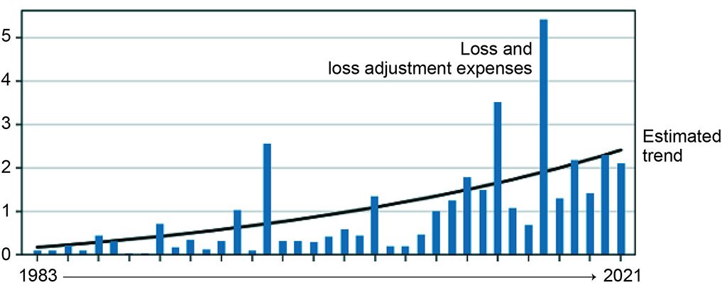
Image Description
This bar graph shows the value of insured losses due to extreme weather in Canada between 1983 and 2021. It shows that there is a strong trend of increase in the values of these losses over time.
Source: Adapted from information derived from the Insurance Bureau of Canada (2022) and the Intact Centre on Climate Adaptation Report Treading Water: Impact of Catastrophic Flooding on Canada's Housing Market (February 2022).
Note: Claims have been normalized for inflation ($2021) and per capita wealth accumulation.
In recent years, flooding has caused approximately $1.5 billion in household, property and infrastructure damages annually (~$700 million in insured losses and $800 million in uninsured losses), with residential property owners bearing approximately 75% of uninsured losses each year. A recent report by Canada's Task Force on Flood Insurance and Relocation for Adapting to Rising Flood RiskFootnote 58 estimated the cost associated with residential flooding in Canada to be $2.9 billion per year.Footnote 59
In terms of wildland fires, six events have been recorded by the Insurance Bureau of Canada, representing just under one fifth of all losses. This also includes the 2016 Fort McMurray wildland fire, which is the single most expensive insurance loss in Canadian history, and which caused losses of approximately $3.75 billion insured losses and over $7 billion of direct and indirect losses.Footnote 60
While no earthquake has met the Insurance Bureau of Canada's threshold for catastrophic losses to date, the 2013 and Versik (formally known as AIR Worldwide) studyFootnote 61 commissioned by the Insurance Bureau of Canada estimates that a 1-in-500 year (0.2% annual enrollment period)Footnote 62 earthquake in British Columbia at a 9.0-magnitude would result in $75 billion in direct and indirect economic losses (only $20 billion of which is insured), while a smaller but comparable scenario in Eastern Canada (7.1-magnitude) could potentially cost $61 billion.
2.8.3 Indirect and intangible losses
Disaster risks can incur a range of indirect losses that are not easily captured using monetary measures. For example, destroyed or damaged property and infrastructure (both human-made and natural) can disrupt the livelihoods and well-being of individuals and businesses who depend on such infrastructure (e.g., tourism, agriculture workers, hunters, and transportation networks).
Disasters can also cause losses that are more difficult or impossible to measure, such as human lives, injuries or damage to priceless cultural heritage; these are known as intangible losses.Footnote 63 These kinds of losses are borne disproportionately by vulnerable and Indigenous populations. Disasters can also be cascading beyond the direct areas of impact and have an impact on supply chains, food security, and negative impacts to mental health.
Some studies in Canada have begun to quantify indirect and intangible losses as a result of disasters. For example, in 2020, Health Canada published a health impact analysis of air pollution from wildland fire smoke in Canada (for the years 2013 – 2018), which estimated there would be 54-240 premature deaths per year caused by short-term exposure and 570-2500 premature deaths per year due to long-term exposure, as well as many cardiorespiratory morbidity outcomes.Footnote 64 For the years considered in the analysis, the estimated costs associated with acute health impacts of wildland fire smoke ranged between $410 million to $1.8 billion per year, and the chronic health impacts were estimated to cost between $4.3 to $19 billion per year.
The indirect and cascading impacts of the COVID-19 pandemic illustrate the complexity and interconnectivity of pandemic disaster risk and impacts. Statistic Canada's COVID-19 in Canada: A Two-year Update on Social and Economic ImpactsFootnote 65 highlights some key examples of persisting financial uncertainty for business and labour market challenges including adjustments to a post-pandemic world, mental health decline and disruptions to non-COVID related healthcare.Footnote 66
2.8.4 Future costs and benefits of disaster risk reduction efforts and climate change adaptation
It is expected that costs of responding to disasters, in addition to managing climate change impacts, will continue to rise for all sectors, with broad impacts on the economy and for Canadians. There are a variety of reports which have begun to assess, project and analyze these costs. Findings may vary due to the scope and methodology of these reports, but as this section notes, there are clear challenges ahead.
A November 2022 report by the Office of the Parliamentary Budget officer, indicates that the 0.9-degree Celsius average increase in surface temperature and 2.5 per cent increase in average precipitation observed for Canada over 1981 to 2021 (relative to 1961-1990 reference levels), have lowered the level of Canadian real GDP in 2021 by 0.8 per cent (or $20 billion in 2021 dollars).Footnote 67 Further, studies suggests that overall direct economic losses could total $15.3 billion per year by 2030, or $111.1 billion from 2020 to 2030, and that total direct and indirect economic losses could cost between $21 and $43 billion annually by 2050.Footnote 68 Footnote 69 Footnote 70 The extent to which these projections will prove true will depend on the effectiveness of future and ongoing mitigation, and adaptation activities.
Beyond direct and indirect economic losses, adapting to Canada's changing disaster environment will have significant and ongoing costs. Further, the impacts of climate change are likely to have an impact on a broad range of regions or sectors of the economy.Footnote 71 The world's warming climate will accelerate climate- and weather-related damage to some of the Canada's most important infrastructure. As sea levels rise and rainfall increases, flood damage to homes and buildings could increase fivefold in the next few decades and by a factor of ten by the end of the century, with costs as high as $13.6 billion annually.Footnote 72 Early investment in adaptation can substantially reduce the impacts and costs to infrastructure of a hotter and changing climate. A February 2020 report by the Federation of Canadian Municipalities and the Insurance Bureau of Canada estimated that Canada's public and private sectors must invest an average of $5.3 billion annually to build climate change resilience into infrastructure in order to minimize loss and damage.Footnote 73 The Canadian Climate Institute's report also emphasized that proactive investments in climate change adaptation, along with global emissions reductions, can reduce costs by a factor of four.Footnote 74
The Canadian Climate Institute also notes that climate damages impair investments in future productivity because climate change impacts will affect all regions and most economic sectors (e.g., transportation, manufacturing), to varying degrees, across all future climate scenarios.Footnote 75
Although these impacts are challenging it is important to note that studies have demonstrated that disaster mitigation and climate change adaptation projects and activities can have a return on investment between $4.6 and $10 for every dollar spent, with higher returns for non-structural measures (e.g., risk assessment, hazard analysis, mitigation planning) compared to structural measures (e.g., dykes, seawalls, dams, fire breaks, critical infrastructure).Footnote 76
It is also important to note that in addition to post-disaster assistance, the Government of Canada is reducing the risk and the impact of disasters through pro-active investments in prevention and mitigation. Since 2018, $3.86 billion(rounded) has been allocated to the Disaster Mitigation and Adaptation Fund —a program that supports community infrastructure projects aimed at preparing for, withstanding and recovering from disasters. This funding will help protect Canadians from climate change driven hazards such as floods and wildland fire.
Did you know?
It is estimated that for every dollar invested in infrastructure, which includes building climate resilient infrastructure, at least $1.60 in economic growth is generated through job creation and avoided damage costs.Footnote 77
A benefit-cost analysis reportFootnote 78 by the Institute for Catastrophic Loss Reduction commissioned by the National Research Council found that the uptake of four products developed by the National Research Council through the Infrastructure Canada-funded Climate Resilient Buildings and Core Public Infrastructure InitiativeFootnote 79, including the then development of the National Wildland Urban Interface GuidelinesFootnote 80, is estimated to lead to savings of $4.7 billion per year at an estimated cost of $400 million in additional construction costs, for a savings of $12 per $1 invested.Footnote 81
With climate impacts continuing to worsen, it will be important to stay ahead of climate change impacts that affect the physical and mental health of Canadians, ecosystems and biodiversity, cultural heritage, and climate-sensitive economic sectors like forestry, agriculture and fisheries. Increasing negative mental health outcomes for Canadians have cascading effects on broader socio-economic outcomes, leading to increased indirect costs.
International research on investment rates and climate change adaptation measures in the US, UK and the EU suggests that national governments investing 0.66-1.25% of GDP, in adaptation measures, will minimize the worst impacts of extreme weather events.Footnote 82 For Canada, this would represent investments of $13.5-$25.6 billion per year,Footnote 83 with potential returns on investment of $62.1-$256 billion.Footnote 84 Canadian-specific research indicates that proactive climate change adaptation investments can yield returns of up to $15 per $1 invested.Footnote 85
Beyond response and recovery efforts, it is important to ensure that regions experiencing infrastructure deficits are properly prepared for emergency events. Strengthening these areas can minimize the effects that emergency events will have on the lives of the people in these communities.
Increased infrastructure adaptation (e.g., infrastructure that is designed, located, and built to be resilient in the changing climate and extreme weather) can help mitigate possible future losses, especially in areas already experiencing infrastructure deficits and significant climate change impacts, such as in northern Canada.Footnote 86 Accordingly, permafrost thaw is more likely to occur in the north, where there is limited infrastructure and mobility options (e.g., many regions may be fly-in only); therefore, reducing the impacts and costs of permafrost thaw on airports in the north is an important measure to mitigate damage costs and meet regular and emergency mobility needs in these regions.Footnote 87 Through incremental adaptations, the annual net costs of airport infrastructure damage in some northern regions could be reduced by 74 to 88% on average.Footnote 88 Footnote 89
2.8.5 Other federal initiatives advancing disaster risk reduction
In the coming decades, climate change will bring more frequent, intense and diverse extremes weather events, while the cost of direct, indirect and slow-onset impacts will continue to accumulate. Acting now to adapt to climate change can help ensure the wellbeing of all people in Canada.
Advancing climate change adaptation, has become an essential part of Canadian disaster risk reduction efforts. Adaptation in the disaster risk reduction context is about being better prepared to respond to and recover from climate change-related events, reducing the impacts on Canadians and communities. The evidence and stakeholder input gathered though the NRP advances the integration of climate change adaptation into emergency management, and will be used to inform decision-making and strategic investments for disaster risk reduction and resilience.
National Adaptation Strategy
In response to the Government of Canada's December 2020 commitment, the National Adaptation Strategy (NAS) was launched on November 24, 2022. The NAS was developed with provincial, territorial and local governments, Indigenous peoples, other key partners, and the public, and provides a roadmap for whole-of-society action on adaptation that will help prepare communities for the impacts of climate change. It includes goals and targets across five key themes: disaster resilience, health and wellbeing, nature and biodiversity, infrastructure, and economy and workers.
As climate change is now a prominent risk driver in Canada, ensuring that the NRP evidence base supports the NAS will enable better emergency management by advancing a culture of emergency preparedness, data on disaster risk (e.g., flood mapping), and capabilities to improve climate resilience and adaptation in the long term. The NAS includes near-term targets to help improve Canada's resilience to climate-related disasters. These include eliminating mortality, reducing morbidity, displacement, and damage from wildland fire, and protecting households in high-risk flood zones and those subject to flooding from extreme precipitation.
Evidence and stakeholder input gathered though the NRP helps to integrate climate change adaptation into emergency management, which is a key goal of the NAS, and will also inform decision-making and strategic investments for disaster risk reduction and resilience. This integration will improve efficiency across the emergency management system, leverage and align our collective emergency management and climate change adaptation expertise, better prepare communities for emergencies and climate related disasters, and help support greater mechanisms for a timely response and recovery. Important areas of alignment include building resilience to high-profile hazards in Canada, such as floods, wildland fires, and heat events.
Climate change adaptation programming in northern and First Nations communities
For on-reserve First Nation communities, the federal government works in partnership with local governments, provincial and territorial governments and non-government organizations to help communities access emergency assistance services including mitigation, preparedness, response and recovery.
The First Nation AdaptFootnote 90 and Climate Change Preparedness in the NorthFootnote 91 programs provide funding to help these communities assess and respond to the impacts of climate change on community infrastructure and disaster risk reduction, including flood mapping. Under both programs, funding for flood mapping is available.
Overall system-wide transformation
Efforts are being made across the Government of Canada to guide a seriesof phased, system-wide actions to build resilience across all hazards for future emergencies. This approach seeks to work more closely with whole-of-society partners (provinces, territories, Indigenous communities,Footnote 92 municipalities, academia, voluntary and private sectors, and civil society) in order to advance proactive prevention and mitigation efforts, and to ensure that robust response and recovery capabilities are developed and implemented, based on leading evidence and scientific information.
The emergency management system in Canada plays a key role in climate change adaptation. Through this system-wide transformative work, the federal government will call for bold, concrete action to advance collaboration on climate-related challenges and emerging incidents and hazards.
The NRP is identified as necessary for successfully transforming Canada's emergency management system in the short-term. It accomplishes this by providing a means to address known gaps in national disaster readiness (e.g., addressing uneven emergency management capabilities and capacities across the country), and disaster risk reduction (e.g., improving understanding of disaster risks at the national level).
Further, the NRP enhances our knowledge and communication capacity on disaster risks, thereby informing strategic investments in disaster risk reduction activities and capability development.
3. NRP process: building the evidence base
Creating a national picture of disaster risk requires coordination and a common approach to integrate information across all sectors of society, as expertise on disaster risk is spread across multiple jurisdictions, academia, NGOs, organizations, corporations and sectors.
In order to capture a national perspective, whole-of-society stakeholders from across Canada, were invited to participate in risk and capability assessments relevant to their expertise with a focus on understanding national representative risks and gaps within our emergency management system. Risk and capability assessments provide a forward-looking picture of the disaster risks facing Canada and the existing capabilities in our emergency management system to address them. This knowledge is foundational to identifying appropriate interventions to reduce these risks to everyone in Canada, including addressing the disproportionate impacts on vulnerable populations.
To capture the full range of experiences, stakeholders included federal departments and agencies, provinces and territories, municipalities, Indigenous organizations and communities, as well as the academic, private, volunteer, and non-governmental sectors, selected from across different communities living within Canada.
The first round of National Risk Profile (NRP) risk and capability assessments targeted earthquakes, wildland fires, and floods because they were identified as the three costliest hazards that Canadians face, based on average annualized lossFootnote 93 at the time of assessment. Pandemic risk did not receive the same level of attention as the three natural disasters. It was added to the NRP cycle as a later consideration to account for the extraordinary impacts that COVID-19 had on all aspects of society. As a result, the pandemic chapter only provides pandemic lens considerations as they relate to earthquakes, wildland fires, and floods and an executive summary of systemic observations and potential considerations for future pandemics.
For earthquakes, wildland fires, and floods, representative scenarios were developed for each hazard (e.g., Gatineau earthquake) — drawing on probabilistic modelling and historical data — and assessed by stakeholders to improve our understanding of potential impacts, as well as the emergency management capabilities available to prepare for, respond to, and recover from hazard events.
This report combines the results of this assessment with the results of probabilistic modelling by the Government of Canada, and external scientific findings, to provide a comprehensive picture of risk and capabilities.
Additional details on the process undertaken for these risk and capability assessments are attached as annexes to this report: Scenario Development; Risk Assessment Methodology; Capability Assessment Methodology.
3.1 Assessment of risksFootnote 94
From March to April 2021, 12 four-hour virtual risk assessment sessions were conducted with a total of 294 attendees across Canada, from a variety of sectors. Participants were asked to assess each scenario according to five impact categories: people, economy, environment, social function, and government.
Additionally, participants were asked to consider:
- the "Future Lens," which looks at the impacts of climate change, changing demographics, and increasing population density on hazard risks by 2050;
- a “pandemic lens,” which examines how disaster management activities are influenced by public health emergencies;
- Gender-based analysis plus dimensions, including socio-economic vulnerabilities, to more accurately capture the range of factors which contribute to disaster risk; and
- Potential critical infrastructure impacts, including which sectors would be impacted in a hazard scenario, and the additional cascading impacts that will result from interruptions to critical services.
3.1.1 Indigenous engagement
As part of a federally-led representative engagement and consultation process, First Nations, Métis, and Inuit representatives and organizations were invited to participate in the risk assessment sessions. In addition, Indigenous consultants facilitated engagement sessions with Indigenous experts and stakeholders to gather and report on the views and considerations of relevant community risk exposure to floods, wildland fire, and earthquakes, notably with Métis and Inuit communities for whom there was limited open-source data with regard to emergency management.
3.2 Assessment of capabilities
A capability refers to the ability to provide equipment, suitable human and other resources to effectively deal with, or help address an emergency situation or a disaster.
Capability assessments support capability-based planning - an evidence-informed process for reducing risk and building resilience (see Annex D: Capability Assessment Methodology, for details).
Stakeholders evaluated select capabilities (e.g., hazard monitoring and early warning) from the Canadian Core Capability List,Footnote 95 in relation to each hazard scenario. To assess Canada's current capability to prepare for, respond to, and recover from disaster events, select stakeholders participated in a survey to assess capabilities to:
- identify baseline levels of capability across Canada;
- establish targeted levels of capability;
- determine existing gaps between the baseline and target capability; and
- identify opportunities to build capacity and resilience across all hazards. (See Annex D: Capability Assessment Methodology)
Capabilities were assessed on a five-point scale:
- Critical shortfall:
- Several elements of this capability are not sufficient and will jeopardize successful delivery of this capability;
- Serious shortfall:
- One element of this capability is not sufficient and will likely jeopardize successful delivery of this capability;
- Minor shortfall:
- Additional risk may be realized if interventions are not made to improve one or more of the elements of this capability;
- Adequate:
- Taken together, the elements of this capability are near optimal; and
- Strong:
- This capability is very robust. Reallocation to other capabilities may be considered, given surplus strength, as necessary.
Using the current state of the capability as a baseline, stakeholders provided input on what level of capability was required to reduce risk to an acceptable level. The gap between the baseline assessment and the desired future state (target) provides insight on where action is required to address capacity and competence gaps in Canada's readiness levels to respond to disaster risk.
The risk and capability assessment data collected, provides high-level conclusions that can inform resilience and risk reduction activities. Input was also received on how to refine data collection and assessment to improve NRP best practices for future reports.
3.3 Data limitations
This first public report of the NRP reflects the findings of the first round of national risk and capability assessments. Best efforts were made to engage with national stakeholders with emergency management and disaster risk reduction expertise across the country, but in some areas there were gaps in terms of the number and breadth of participants who could engage fully in this process. Therefore, although a robust methodology was used to develop this report, it may not be prudent to view its findings as completely definitive as data collection for this round was not fully comprehensive. Moving forward, work will continue to ensure that the NRP's whole of society engagement expands with greater, more representative input from stakeholders with relevant lived experience and expertise who are best placed to provide insight on the broad range of disaster risks and impacts for communities across Canada. These efforts are already well underway for future rounds.
As this report is based on the first NRP research process, there are limitations in data availability. Efforts to strengthen sampling and familiarity with content are ongoing as the NRP methodology is refined. The NRP risk assessment results reflect significant contributions from representative engagements with a wide range of emergency management experts, community members and stakeholders from across Canada. Participants were referred by the federal interdepartmental committee that is providing strategic leadership and guidance on NRP research and report development, as well as provincial and territorial partners, and through direct engagement. In order to provide a quality environment for data collection, the project committed to anonymizing data and input based on the individual's professional role. All stakeholders participated on a voluntary basis and the data collected is based on their varied individual expertise and experiences.
The results of this report are based on the assessment of representative hazard scenarios. These findings are intended to illustrate a broad range of disaster risks and impacts and increase our understanding of the capabilities needed to prevent, mitigate, respond to, and recover from these events. The data presented is a complement to, but not a substitute for, probabilistic hazard modelling. Lessons learned on data limitations will be addressed in the development of future NRP reports.
The following chapters provide a detailed overview of earthquakes, wildland fires, and floods. Given the varying levels of knowledge and evidence for each of the hazards, the chapters differ in terms of structure and information presented.
4. Hazard: Earthquakes
An earthquake occurs when the Earth's crust slips suddenly along faults or fault planes and releases massive amounts of energy in the form of seismic waves. These waves cause the ground to shake and can be felt up to hundreds of kilometers away from the earthquake origin. Much of the damage caused by earthquakes results directly from these seismic waves, but secondary impacts can also include tsunamis, landslides, fires,Footnote 96 and liquefaction (weakening of the ground surface). Globally, earthquakes account for approximately one fifth (20%) of natural hazard-induced disasters and have an average annual death toll of over 25,000.
Earthquakes are measured on a magnitude scale, which reflects the amount of energy released in a seismic event. The severity of an earthquake depends on the magnitude, location, ground conditions, construction standards, and other factors in the affected area. Devastating events such as those in Japan (magnitude 9.0 in 2011), New Zealand (magnitudes 7.1 and 6.2 in 2010 and 2011 respectively), and Northridge, USA (magnitude 6.7 in 1994) help us understand the potential impacts of an earthquake occurring in Canada.
4.1 Understanding earthquakes in Canada
Our knowledge of earthquakes has advanced immensely over the past few decades as a result of sustained investment in hazard research and monitoring. While it is not possible to predict earthquakes, probability estimates are used to better understand the seismic hazard in various regions.
Historically, the west coast of Canada has experienced magnitude 9 earthquakes and associated tsunamis. The Yukon and Northwest Territories, Arctic islands, and Canada's east coast have also experienced events of considerable magnitude.
The most active region in eastern Canada is the Charlevoix Seismic Zone, located in north-eastern Quebec. Due to the geology of this region, ground shaking from even moderate earthquakes can have widespread effects. Over the past 350 years, at least five earthquakes greater than magnitude 6.0 have occurred in this region.Footnote 97 Expected losses from a 1-in-500 year earthquake in the Charlevoix Seismic Zone or on Canada's West Coast would be higher than any natural hazard the country has experienced.Footnote 98 Footnote 99
The Western Quebec Seismic Zone constitutes a vast territory that encloses the Ottawa Valley from Montreal to Timiskaming, as well as the Laurentians and the Eastern Ontario. The Western Quebec Zone was the site of at least three significant earthquakes in the past, all of which were a magnitude of 5 or higher.
Indirect impacts of earthquakes reach far beyond the strongly-shaken area, potentially across the country and internationally, which underscores the value of a whole-of-society approach to risk management to help manage these indirect impacts.
Did you know?
On average, more than 5,000 earthquakes are recorded each year in Canada, of which about 50 are felt.
Canada's two most active port cities (Montreal and Vancouver) are at high risk of experiencing a large earthquake in the next 25 years. Rail lines and highways to these ports as well as the ports themselves are also at risk and lengthy disruption to these transport corridors could have major economic impacts on the regional economies of Western/central Canada. For instance, the Port of Vancouver handles nearly $275 billion of goods per year with over 170 different trading economies.Footnote 100
4.1.1 Earthquake risk management
Earthquake risk is managed at all orders of government through policy, mitigation, and risk transfer strategies. At the federal level, related activities include: emergency management, earthquake monitoring and alerting, research and risk assessment, regulation of development and the built environment, and critical infrastructure resilience considerations (retrofitting government buildings, seismic upgrades to major bridges), intergovernmental mutual aid arrangements, and financial services supervision.
4.2 Earthquake exposure and likelihood – who and what is at risk?
There are several factors that impact earthquake risk across Canada. The infrequent nature of earthquake events and the broad lack of public risk awareness, particularly in Ontario and Quebec, have led to low levels of general preparedness. For example, many people may not know what to do during an earthquake (“drop, cover, and hold on”).Footnote 101
Most at-risk Canadians are uninsured or under-insured for earthquakes. This is most pronounced in Quebec, where fewer than 5% of households have earthquake insurance. In British Columbia, this figure is between 40% to 70% of residential properties. Although the number of households with residential property insurance is relatively high in British Columbia, the terms and deductibles of these insurance policies may limit effective coverage.
The Insurance Bureau of Canada notes that earthquake insurance is usually available to be purchased as an add-on to a home insurance policy, and the Disaster Financial Assistance Arrangements does not cover losses for which insurance is available at a reasonable cost. Earthquake insurance is subject to a higher deductible than coverage for other perils and may not cover all damages resulting from an earthquake event (e.g., Tsunami related damage or land damage as a result of landslides or liquefaction).Footnote 102
Furthermore, there are many older and/or historical buildings that were constructed before seismic provisions were introduced into the building code, including in downtown cores, Indigenous communities, and residential zones. Current building codes in Canada typically include requirements only for life safety. This means that they are built to allow for safe evacuation, but not for safe use thereafter without substantial and costly repairs (with the exception of some critical infrastructure, such as hospitals).
4.2.1 Possible losses
A report by the Insurance Bureau of Canada and Versik (formally known as AIR Worldwide) estimates that a severe earthquake in British Columbia — 9.0-magnitude — could result in $75 billion in losses and a similarly probable event in the Quebec City-Montreal-Ottawa corridor could result in $61 billion in losses.Footnote 103
In addition to economic losses, a major earthquake event could cause widespread and long-term social and economic disruption in the affected region and beyond. When looking at losses, it is also important to note that earthquakes are sometimes followed by major fires, whose damage can greatly exceed the damage due to shaking. A report prepared for the Institute for Catastrophic Loss Reduction (ICLR) noted that fire losses may result in up to $10 billion, which would be fully insured, in addition to the partially insured losses from ground shaking.Footnote 104
4.3 Understanding differential impacts of earthquakes – who is most vulnerable?
Anyone living or working in a structure that was constructed in an earthquake-prone region before seismic provisions were included in local building codes is at greater risk.Footnote 105 Children, seniors, and those with mobility, sensory, and cognitive disabilities are particularly vulnerable. Low-income households are less likely to be able to recover losses that result from earthquake events. Rural and remote communities that have minimal access to transportation infrastructure will face challenges with evacuation planning and access to resources for response and recovery. This is also relevant for Indigenous communities, and on reserve lands, where there may be limited resources and funding for emergency management.
4.3.1 Risk for Indigenous peoples and remote communities
Much of the infrastructure in some Indigenous communities and on reserve lands is aging and there is no detailed analysis of Indigenous community infrastructure to identify what seismic upgrades might be needed.Footnote 106 This infrastructure gap leads to greater risk posed by earthquakes, as limited and aging infrastructure is less able to withstand earthquake impacts, and not easily repaired following an incident.
Remote and isolated areas may be subject to damaging ground shaking, tsunami inundation, landslides, and liquefaction, as well as fires or critical infrastructure failures. Indigenous participants in the NRP assessment processFootnote 107 noted that due to capacity limitations, building codes are not consistently applied across Indigenous communities, leading to additional vulnerability in built infrastructure. Assessment sessions for the NRP with some Indigenous experts, organizations and stakeholders also revealed that infrastructure failures or compromised, limited and single-road access could make it difficult to access basic needs (e.g., potable water) and the provision of essential goods and services.Footnote 108
Participants also noted that earthquake impacts to the environment, including land and wildlife, can significantly affect cultural practices, community wellness, and the fulfillment of basic needs such as harvesting and hunting. In some cases, cultural sites that are land-based may be entirely lost.
4.4 Understanding risk drivers – how is earthquake risk changing?
Physical and social vulnerabilities represent the most prominent drivers of earthquake risk in Canada. Earthquake risk is changing as a result of the demographic shift towards an aging population, increasing urban population density, the accumulation of assets in earthquake-prone areas, and an increased dependence on power, water, and telecommunications utilities. Other considerations driving earthquake risk in Canada include variances in public awareness of seismic risk. Recent evidence suggests that climate change is having an impact on seismic risk. This has been seen both through increases in earthquake rates in areas where ice sheets in the Arctic are thinning quickly, as well as through degradation of permafrost, resulting in soils that are more vulnerable to strong shaking and failure during shaking.
4.5 NRP earthquake risk assessmentsFootnote 109
Drawing on expert knowledge and available data (including insights gained from probabilistic modelling results), seismologists from Natural Resources Canada developed four earthquake scenarios used for risk assessment. For each scenario, a narrative was constructed describing the magnitude and location of the earthquake. The severity and scope of each event was selected to match the associated average annual loss value. Each earthquake scenario notes strong and damaging shaking that triggers several different impacts such as landslides, infrastructure and highway damage, power outages, port closures, and tsunamis.
NRP risk assessment participants assessed the consequences of these earthquake scenarios across five impact categories: people, economy, environment, government, and social. The results of this assessment are summarized below. Additional information — drawn from the broader literature on earthquakes — has also been incorporated.
The complete risk assessment results can be found in Figure 3: NRP earthquake risk results.
Figure 3: NRP risk assessment scorecard: earthquakes
Total average risk = Likelihood x Average consequence
Total average risk rating range: 6.0–9.6Footnote 110
Total average future trend: Significant increasing
Total average confidence: Medium
| Scenario size descriptorFootnote 111 | Scenario size ($M) | Likelihood |
|---|---|---|
| Minor (2) | 100 (Yukon) | Very low |
| Moderate (3) | 1,000 (Galiano) | Moderate |
| Major (4) | 10,000 (Ottawa-Gatineau) | Low |
| Catastrophic (5) | 100,000 (Cascadia) | Low |
| Average likelihood | Low |
| Risk drivers | Future trend | Average score | Explanation |
|---|---|---|---|
| Climate Change | Moderate increasing | 3.9 | Both densification including the accumulation of assets and changing demographics due to an aging population increase risk within earthquake-prone areas. Climate change increases the conditions for secondary impacts such as landslides and liquefaction. |
| Population density | Significant increasing | 4.0 | Both densification including the accumulation of assets and changing demographics due to an aging population increase risk within earthquake-prone areas. Climate change increases the conditions for secondary impacts such as landslides and liquefaction. |
| Demographics | Moderate increasing | 3.9 | Both densification including the accumulation of assets and changing demographics due to an aging population increase risk within earthquake-prone areas. Climate change increases the conditions for secondary impacts such as landslides and liquefaction. |
| Impact category | Consequence type | Rating range | Explanation | ConfidenceFootnote 112 |
|---|---|---|---|---|
People |
Fatalities and injuries |
4.0–5.0 |
Up to 7,600 people affected due to building collapse, landslides, critical infrastructure failure, liquefaction, electrical fires, collisions, etc. |
High |
Economy |
Direct and indirect loss |
2.0–5.0Footnote 113 |
Income loss, business disruption, production decline, damaged to the supply chain, evacuation costs, insurance loss, and restoration activities range from $79M to $79B+.Footnote 114 |
AAL Values |
Environment |
GHG, water quality, air quality, eco‑systems, species, flora, and fauna |
3.0–5.0 |
Damage to the environment may include debris clean-up, environmental spills, damaged permafrost, water supply, and eco-system disruption. |
Medium |
Government |
Ability to govern, reputation, and influence |
3.0–4.0 |
Medium impacts include maintaining trust and transparency across levels of government. Crisis management demands coordinated and effective response. |
Medium |
Social |
Displacement and social cohesion |
3.0–5.0 |
Displacement could impact a large portion of regional communities over a long period of time. Recovery could take upwards of 10 years. |
Medium |
4.5.1 Findings: people impact category
The earthquake scenarios were in the range of major to catastrophic on the people consequence rating scale (Annex C: Risk Assessment Methodology).
Human life, physical health, and mental well-being are significantly impacted by earthquake events. Injuries sustained during earthquakes are primarily movement and fall-related: often caused by running out of a building or attempting to move to safety or from objects falling from shelves or ceilings.
In the aftermath of an earthquake, emergency services, including hospitalizations are likely to exceed capacity, overwhelming the health care system.Footnote 115 Non-fatal injuries often exceed fatalities by orders of magnitude and are driven mostly by non-structural damage (e.g., overturned furnishings and broken glass). Large earthquake disasters also lead to traumatic experiences that increase mental health risk and reduce psychosocial well-being. Limitations on the ability to react, such as mobility difficulties or limited earthquake preparedness knowledge, may increase the risk for some individuals such as seniors, newcomers, or visitors.
Loss of life often occurs during a building collapse or critical infrastructure failure (e.g., dams, power lines, bridges, roadways, etc.) or due to inundation after an earthquake. In these situations, debris and rubble can hamper first responders' ability to provide aid. As noted earlier, older buildings, particularly those with unreinforced masonry and those in residential areas, often do not conform to building codes and pose a greater risk of collapse. Damage to buildings' energy and gas lines can also cause fires (e.g., the 1906 San Francisco earthquake resulted in a fire that destroyed 28,000 buildings and over 3,000 fatalities).Footnote 116
There are also a number of indirect impacts related to earthquakes, including loss of access to food, potable water, medication, and services. Remote communities may find themselves cut off from critical supplies and services and single-road-access or fly-in communities face evacuation and recovery challenges. Water may be tainted when remote communities' local resources such as groundwater systems are damaged or exposed to leaks, posing health impacts. This is also a concern for Indigenous communities. Reserves are often located in rural and remote regions, where connection to medical services and critical infrastructure may be impeded.
4.5.2 Findings: economy impact category
The four earthquake scenarios were developed where direct and indirect economic loss was assessed at $100 million, $1,000 million, $10 billion, and $100 billion (See Figure 3).
This places the scenarios in the range of minor to catastrophic on the economy consequence rating scale (Annex C: Risk Assessment Methodology).
Large earthquake events differ from most other hazards due to their widespread and long-term impacts, and their potential to cause extensive social and economic disruption in the affected region and beyond. The disruption caused can include impacts on supply chains, employment, and loss of critical services such as power, water, and telecommunications.
Removal of earthquake debris and repair services (notably for older and pre-code building structures) result in significant costs, as does liquefaction and surface flooding which damage roads. While this can happen anywhere, this risk is particularly strong in lower mainland British Columbia due to soil type and in northern communities where buildings constructed on permafrost are at high risk of sinking if the permafrost is damaged due to earthquakes or climate change, posing significant remediation costs.
Indirect costs have a significant impact on total disaster loss. They are often more uncertain than property repair costs and can be more difficult to estimate as there are challenges with evaluating the opportunity costs associated with productivity loss. For instance, tourism-dependent industries in seismically active areas often suffer significant interruption following an event. Further, there are delays in production as it takes time to rebuild and recover from damage to historical buildings, natural landscapes, and industry operations (where relevant). Both regional and domestic trade disruptions are expected when earthquakes impact transportation corridors, bridges, and major economic centers. These disruptions cause supply chain issues, could lead to food shortages and associated revenue losses.
Earthquake insurance is not included in standard home insurance policies. An Insurance Bureau of Canada study found that 55% of people living in British Columbia are uninsured whereas up to 96% of people living in Quebec do not have earthquake coverage.
4.5.3 Findings: environment impact category
The earthquake scenarios were in the range of moderate to catastrophic on the environment consequence Rating Scale (Annex C: Risk Assessment Methodology).
Earthquakes have significant impacts on the natural environment and structural and non-structural componentssuffer greater damage, generating higher carbon costs when rebuilding.Footnote 117 Damaged buildings can create significant amounts of debris and dust clouds, which impact air quality. Asbestos, released from older buildings, may impact human health and safety. These effects can be exacerbated when fires are triggered by seismic activity. Response and rebuilding activities, including transportation of materials, may increase greenhouse gas emissions.
Environmental spills resulting from damage to infrastructure in residential and industrial zones, as well as resource extraction sites, can expose damaging materials (chemicals, raw materials, wastewater, and oil) that may in turn negatively impact water supplies, water quality, ecosystems, and nearby communities. Damage to permafrost can lead to increased release of methane gasses, potentially impacting northern communities and disrupting ecosystems. Land deformations and landslides triggered by earthquakes may also negatively impact migrating animals and fish habitats. Finally, soil erosion is often accelerated by earthquakes, changing coastlines, and ecosystems.
4.5.4 Findings: government impact category
The earthquake scenarios were in the range of moderate to major on the government consequence rating scale (Annex C: Risk Assessment Methodology).
All orders of governments play a critical role in prevention efforts that aim to mitigate risk, reduce impacts, and build capacity and resilience. Investments in mitigation measures such as better land-use planning, improved flood and fire infrastructure, and retrofitting public buildings and assets, can reduce the damage caused by an earthquake. Other government investments, such as early warning systems, provide advance notice and allow people to act quickly in seeking shelter.
Canadians look to governments to provide leadership and support during and after disasters. Given the federal government's role in supporting economic recoveries through employment insurance and other discretionary measures, the federal fiscal balance could be impacted by earthquake risks. Depending on the broader economic effects of the earthquake, the fiscal balance could also be impacted by change in tax revenue, exchange rates, and inflation. Particularly, governments in remote and Indigenous communities have limited ability to provide post-event support straining their ability to meet expectations.
4.5.5 Findings: social impact category
The earthquake scenarios were in the range of moderate to catastrophic on the social consequence rating scale (Annex C: Risk Assessment Methodology).
Displacement has far-reaching impacts on communities disrupting livelihoods, social connections, sense of place, and items of historical and cultural significance. School disruptions negatively impact children and youth, and caregivers are required to take on additional responsibilities to support minors. Vulnerable groups may find it challenging to cope, especially where job losses occur and impact earning potential. During evacuation, pets that are left behind need to be housed, cared for, and reunited with their owners. Research indicates that domestic violence often increases in the aftermath of a traumatic event. Historic and cultural loss may impact social cohesion within a community.
4.6 Earthquake capability assessments
The goal of effective earthquake preparedness is to build resilience and reduce financial, social, and physical vulnerabilities associated with possible earthquake events. The development of the NRP is an important mechanism for consolidating capability assessments focused on representative engagement. Targeted capability assessment seeks to better understand the ability of Canadian communities and jurisdictions to prepare for earthquakes, adapt to changing risk environments, and recover from disruptions.
In 2021-22, NRP capability assessment participants were engaged to:
- Identify baseline levels of capability across Canada;
- Establish targeted levels of capability;
- Determine existing gaps between the baseline and target capability; and
- Identify opportunities across disaster hazards to build capacity and resilience.Footnote 118
Thirty-four capabilities, out of thirty-eight, from the Canadian Core Capabilities List (CCCL) were assessed by NRP capability assessment participants in relation to the earthquake scenarios. Ten of these were assessed as having minor shortfalls, twenty-two as having serious shortfalls, and two capabilities were assessed as having a critical shortfall. Additionally, twenty-three of the thirty-four capabilities were assessed as having a significant gap — between the current and desired state — 1.5 or higher (on a scale of 1 to 5). Fifteen of these had gaps of 2 or more.
The complete capability assessment results are below in Figure 4.
Figure 4: NRP capability scorecard: earthquakes
Baseline versus Target
Average baseline: 2.7
Average target: 4.5
Average gap: 1.8
Total average confidence: Low
| Core capability | ConfidenceFootnote 119 | Baseline | Target | Gap |
|---|---|---|---|---|
CCCL 1: Whole-of-Society Interoperability |
Low |
3.1 |
4.7 |
1.6 |
CCCL 2: Whole-of-Society Governance |
Low |
2.9 |
4.3 |
1.4 |
CCCL 3: Whole-of-Society Collaboration |
Medium |
3.5 |
5 |
1.5 |
CCCL 4: Indigenous Collaboration |
Medium |
1.8 |
4.9 |
3.1 |
| Core capability | Confidence | Baseline | Target | Gap |
|---|---|---|---|---|
CCCL 5: Risk Assessments |
Low |
3.3 |
4.4 |
1.1 |
CCCL 6: Intelligence Information SharingFootnote 120 |
Medium |
3.0 |
4.0 |
1.0 |
CCCL 7: Hazard Monitoring and Early Warning |
Low |
2.5 |
4.8 |
2.3 |
CCCL 8: Public Information and Awareness |
Low |
3.1 |
4.4 |
1.3 |
| Core capability | Confidence | Baseline | Target | Gap |
|---|---|---|---|---|
CCCL 9: Critical Infrastructure Resilience |
Low |
2.7 |
4.8 |
2.1 |
CCCL 10: Property Resilience |
Low |
2.6 |
4.6 |
2.0 |
CCCL 11: Public Infrastructure Resilience |
Low |
2.8 |
4.5 |
1.7 |
CCCL 12: Emergency Planning |
Medium |
3.6 |
4.8 |
1.2 |
CCCL 14: Structural Risk Reduction Measures |
Low |
2.8 |
4.5 |
1.7 |
CCCL 15: Non-Structural Risk Reduction Measures |
Low |
2.6 |
4.5 |
1.9 |
CCCL 16: Environmental Risk Reduction |
Low |
2.7 |
4.3 |
1.6 |
| Core capability | Confidence | Baseline | Target | Gap |
|---|---|---|---|---|
CCCL 17: Emergency Public Alerting |
Low |
3.2 |
4.6 |
1.4 |
CCCL 18: Emergency Evacuation and Transportation |
Low |
2.6 |
4.4 |
1.8 |
CCCL 20: Specialized Response - Search and Rescue |
Low |
2.8 |
4.4 |
1.6 |
CCCL 21: Specialized Response Hazmat / CBRNEFootnote 121 |
High |
1.0 |
3.0 |
2.0 |
CCCL 24: Public Health / Medical Services |
Low |
2.5 |
4.6 |
2.1 |
CCCL 25: Operational Coordination |
Medium |
2.9 |
4.3 |
1.4 |
CCCL 26: Operational CommunicationsFootnote 121 |
High |
2.0 |
5.0 |
3.0 |
CCCL 27: Emergency Legal and Financial AdviceFootnote 121 |
Low |
2.0 |
5.0 |
3.0 |
CCCL 28: Emergency Logistics |
Medium |
2.4 |
4.7 |
2.3 |
CCCL 29: Emergency Social Services |
Low |
2.9 |
4.3 |
1.4 |
CCCL 30: Fatality Management ServiceFootnote 121 |
Low |
2.0 |
5.0 |
3.0 |
CCCL 31: Training and Education |
Medium |
3.0 |
4.3 |
1.3 |
CCCL 32: Exercising |
Medium |
3.3 |
4.3 |
1.0 |
CCCL 33: Critical Infrastructure Restoration |
Low |
2.2 |
4.4 |
2.2 |
| Core capability | Confidence | Baseline | Target | Gap |
|---|---|---|---|---|
CCCL 34: Psychosocial Health |
Low |
2.3 |
4.8 |
2.5 |
CCCL 35: Environmental Restoration |
Low |
3.5 |
4.0 |
0.5 |
CCCL 36: Cultural RestorationFootnote 122 |
Low |
2.5 |
4.5 |
2.0 |
CCCL 37: Economic Recovery |
Low |
2.5 |
4.6 |
2.1 |
CCCL 38: Property Recovery |
Low |
2.6 |
4.7 |
2.1 |
4.6.1 Gaps in earthquake resilience
Three key gaps in Canada's resilience to earthquake risk were identified in relation to the following Canada's Emergency Management Strategy priority areas:
- Priority 1: Enhance whole-of-society collaboration and governance to strengthen resilience
-
- A lack of standardized, national systems for identifying, prioritizing and retrofitting buildings at risk from structural damage from earthquakes to reduce potential losses (mitigation of pre-event structural risk).
- Priority 2: Improve understanding of disaster risks in all sectors of society
-
- Due to the low frequency of earthquake events, awareness of catastrophic earthquake risk and associated preparation activity is low, with many underinsured and uninsured Canadians living in at-risk zones.
- Knowledge and data on earthquake hazard risk, while accessible, is not well understood across Canada as well as necessary actions to take during an earthquake. (i.e., drop, cover, and hold on).
- Priority 3: Increase focus on whole-of-society disaster prevention and mitigation activities
-
- Earthquake insurance is not included in standard home insurance policies.
- There are gaps in established procedure for response logistics, business continuity, and communication following an event — partially due to the low frequency of catastrophic earthquakes — planning and preparedness is not at the baseline/desired threshold.
4.7 Moving forward
Our understanding of earthquake hazards is rapidly evolving and improving as more data becomes available and we learn from events in Canada and around the world.
For example, there are still significant uncertainties around the potential size and frequency of earthquakes, with few identified active faults in Canada. As such, continued seismic hazard research will contribute to an improved understanding of earthquake risk in support of risk reduction decisions. To that end, Natural Resources Canada is conducting research to fill these gaps by mapping and studying current and past seismic activity to understand what the future may bring, and continues to seek opportunities as technology advances to improve monitoring of earthquakes, particularly in regions where current network coverage is weak such as remote Arctic areas.
In addition to this research, starting in 2019, the Government of Canada invested $5.95 million over five years to develop a National Earthquake Risk Assessment Framework as part of the NRP. This initiative has developed a neighbourhood-level profile of earthquake risk from ground shaking,Footnote 123 ensured access to open-source earthquake data and risk assessment software, and incorporates stakeholder engagement to develop guidance on how this work can support actions that reduce risk. The modelling for the Framework includes information on potential building damage, injuries and casualties, shelter needs, debris generated, and direct economic loss from earthquake events. The National Earthquake Risk Assessment Framework provides the necessary base of evidence to inform and evaluate actionable earthquake risk reduction strategies, planning, and policy development at all scales to reduce future losses. This model is now publicly available to support improved risk reduction decisions by emergency managers, planners, the public, and the financial sector.
Natural Resources Canada is implementing a national earthquake early warning system, scheduled to be in operation in 2024. It will provide extremely rapid warning to critical infrastructure and people prior to shaking from an earthquake in their location. In some situations it will offer seconds to a minute of advance warning, sufficient for preventative measures to be taken, including opening doors at fire and ambulance stations, delaying landings for aircraft, stopping bridge and tunnel traffic, and halting surgical procedures.
Targeted, consistent, accessible and clear communication of earthquake risk is required across sectors to support informed decision-making. The Organization for Economic Co-operation and Development report “Financial Management of Earthquake Risk” noted the importance of the quantification of earthquake risk for effective risk management.Footnote 124 For example, it indicated that enhancing public awareness about earthquake risk generally leads to higher insurance coverage. This helps homeowners understand their relative risk, supports policy makers in developing programming, and contributes to effective and targeted action by all orders of government. Findings from the NRP will contribute to this goal by providing an improved understanding of earthquake risk across the country.Footnote 125 Earthquake damage and injuries can be mitigated through the implementation of modern earthquake-resistant building standards and education campaigns that protect human life.
Work is underway to build resilience to earthquake risk, including development of insurance-based strategies for addressing hazard protection gaps; technical and policy guidance on prioritizing and incentivizing seismic retrofit programs for older buildings; and comprehensive and accessible knowledge and data to understand and communicate earthquake hazard and risk. The NRP will inform this work and provide a venue for ongoing coordination and discussion to ensure a whole-of-government approach.
Given the challenges outlined above, additional consideration for how earthquakes affect northern, Métis, off-reserve First Nations, urban Indigenous, and Inuit communities is important to further our understanding of disaster risk in Canada.
5. Hazard: Wildland Fires
Wildland fires are a complex natural hazard that depends on the dynamic interplay between climate (and its subset weather), fuels that the fire burns, ignition sources (such as lightning), and topography (the forms and features of the land). The term “wildland fire” includes fires ignited by unplanned human-caused fires, and intentional prescribed fires where fire managers and other land users deliberately apply fire to the landscape.Footnote 126
Wildland fires burn in forests, shrub land, and grassland ecosystems, or in any flammable wildland vegetation known as fuels.Footnote 127 Wildland fires are a natural part of nearly every Canadian terrestrial ecosystem and can contribute to the health and diversity of Canada's ecosystems.
Wildland fires can also be a hazard — they can harm ecosystems, endanger human lives and communities, threaten industry, and damage infrastructure. The negative impacts of wildland fires can also include secondary impacts such as increased risk of landslides and flooding after fires, and widespread human health impacts from wildland fire smoke.
5.1 Understanding wildland fires in Canada – how does it impact us?
Over the last 40 years, approximately 7,000 wildland fires occur each year in Canada — most frequently in British Columbia and the boreal forest zones of Ontario, Quebec, the Prairie provinces, the Yukon, and the Northwest Territories. The total area burned varies widely from as little as 0.5 million hectares to over 7 million hectares per year, but averages about 2.5 million hectares annually.Footnote 128
Since the 1970s, the area in Canada burned annually by wildland fires has more than doubled, and this amount is predicted to double again by 2100. Canadians are also experiencing increased property and socio-economic losses and health issues due to wildland fire activity and wildland fire smoke. Governments, citizens, and private industry are seeing higher response and post-event recovery costs; between 1980 and 2021, average wildland fire evacuation events and number of evacuees have shown notable increases.Footnote 129
Figure 5: Number of fires and area burned in Canada by year
Image Description
This image shows two graphs: first, the number of fires in Canada per year and second the area burned in hectares per year between 1980 and 2021. There is a wide range of values across both charts with no clear trend line. The detailed data used to make these graphs is found in the table below.
| Year | Number of fires | Total area burned (hectares) |
|---|---|---|
| 1980 | 7,483 | 4,824,670 |
| 1981 | 9,241 | 6,284,405 |
| 1982 | 7,748 | 1,757,247 |
| 1983 | 7,978 | 2,014,469 |
| 1984 | 8,484 | 761,796 |
| 1985 | 7,760 | 847,535 |
| 1986 | 6,090 | 1,005,868 |
| 1987 | 10,463 | 1,017,627 |
| 1988 | 10,168 | 1,351,568 |
| 1989 | 12,015 | 7,597,266 |
| 1990 | 9,972 | 953,222 |
| 1991 | 10,183 | 1,545,669 |
| 1992 | 8,967 | 851,783 |
| 1993 | 5,948 | 1,950,265 |
| 1994 | 9,636 | 6,161,327 |
| 1995 | 8,416 | 7,375,319 |
| 1996 | 6,379 | 1,861,750 |
| 1997 | 6,056 | 632,642 |
| 1998 | 10,741 | 4,740,953 |
| 1999 | 7,574 | 1,717,066 |
| 2000 | 5,397 | 634,155 |
| 2001 | 7,716 | 647,640 |
| 2002 | 7,849 | 2,763,473 |
| 2003 | 8,256 | 2,168,393 |
| 2004 | 6,468 | 3,182,984 |
| 2005 | 7,439 | 1,686,720 |
| 2006 | 9,718 | 2,100,629 |
| 2007 | 6,911 | 1,785,449 |
| 2008 | 6,235 | 1,664,922 |
| 2009 | 7,137 | 762,564 |
| 2010 | 7,312 | 3,177,960 |
| 2011 | 4,674 | 2,397,422 |
| 2012 | 7,910 | 1,811,679 |
| 2013 | 6,246 | 4,268,421 |
| 2014 | 5,016 | 4,545,655 |
| 2015 | 7,029 | 3,908,377 |
| 2016 | 5,259 | 1,319,573 |
| 2017 | 5,654 | 3,589,423 |
| 2018 | 7,111 | 2,328,851 |
| 2019 | 4,062 | 1,786,214 |
| 2020 | 4,001 | 218,232 |
| 2021 | 6,709 | 4,078,897 |
Source: The chart and table above show statistics extracted from the Canadian National Fire Database.Footnote 130 They show the high variability in both the number of fires and area burned in Canada per year from 1980 to 2021, and provide a comparison with the National Forestry Database numbers.
5.1.1 Wildland fire management
Wildland fire management is the process of planning, preventing and responding to wildland fire events, protecting, people, property (built and natural infrastructure), wildlife, and forest resources. It also includes the use of prescribed burning for forest management, wildlife and other land use objectives. Wildland fire management has evolved over the years, responding to changes and a better understanding of best practices in risk management (e.g., ranging levels of fire response; prescribed burningFootnote 131).
Responsibility for wildland fire management in Canada (including response and mitigation) rests primarily with the provinces and territories. The Government of Canada has responsibilities for federal emergency response coordination, disaster financial assistance to provinces and territories and national situational awareness for wildland fire events if requested by wildland fire management agencies. Areas of federal responsibility also include national parks and military bases. The Canadian Armed Forces may also be requested to assist in disaster response (e.g., Operation LENTUSFootnote 132).
Advances in wildland fire research have created an improved understanding of fire processes and the practical requirements of addressing fire risk have led to the development of operational tools. Notably, the Canadian Forest Service of Natural Resources Canada developed the Canadian Forest Fire Danger Rating System.Footnote 133 This system, and its two main sub-systems, the Fire Weather Index SystemFootnote 134 and Fire Behaviour Prediction SystemFootnote 135 provide an assessment of the current fire environment and are used extensively in operational wildland fire decision-making. These tools have been adopted around the world as models for helping countries understand their fire danger levels (most recently in the United Kingdom in 2022).
Natural Resources Canada's Canadian Forest Service also maintains and operates the Canadian Wildland Fire Information SystemFootnote 136, which provides national situational awareness for wildland fire and situational reports. The system integrates data from multiple sources and provides a wide range of products including daily national information on fire danger, fire activity and fire forecasts, national maps and reports, and access to current and archived fire data. During wildland fire season, multiple end-users rely on the Canadian Wildland Fire Information System data to feed into their own operational systems to make informed decisions on wildland fire risk.
Whole-of-society collaboration is essential for managing wildland fire risks in Canada, such as generating and sharing wildland fire risk data, and resources.
Did you know?
The Canadian Interagency Forest Fire Centre is a not-for-profit corporation owned and operated by the federal, provincial and territorial wildland fire management agencies. Established in 1982, Canadian Interagency Forest Fire Centre serves to facilitate the exchange of wildland fire management resources and information for member agencies. Through, committees, working groups, and project teams, Canadian Interagency Forest Fire Centre provides a robust forum for federal, provincial, and territorial collaboration on common operational fire management challenges. This information is used to enhance national wildland fire preparedness, safety, response capability and support prevention and mitigation activities.
5.2 Impacts of wildland fire
All over the world, people are coping with more frequent, intense, and severe wildland fire. Recent wildland fires in Canada serve as examples of a trend driven largely by climate change. The risks to lives and livelihoods is increasing, along with the associated costs to respond to fire events.
5.2.1 Costs of wildland fire events
Wildland fires can have significant negative consequences for the Canadian economy and society. Economic losses from wildland fire events can be difficult to calculate and include direct and indirect costs. Prior to 2003, no single wildland fire in Canada had cost more than $10 million in losses, but this is changing rapidly. Rising suppression costs and economic impacts are evidenced by numerous costly events that have occurred in western Canada over the past decade, including Slave Lake (Alberta) in 2011, La Ronge (Saskatchewan) in 2015, Fort McMurray (Alberta) in 2016 and the fires in British Columbia in 2017, 2018 and 2021.
The 2016 Fort McMurray wildland fire event was the most expensive disaster in Canadian history for insurance providers. The total insured and uninsured costs are estimated at over $7 billion.Footnote 137 About 5,890 km2 of land was burned which is about the size of Prince Edward Island and over 2000 work hours were lost in the natural resources sector (forestry, fishing, mining, oil and gas extraction).Footnote 138
The summer of 2017 was one of the worst wildland fire seasons in British Columbia's history with the record amount of land burned at over 1.2 million hectares, the costliest fire suppression season with expenditures of over $649 million, and the most disruptive with roughly 65,000 people evacuated.Footnote 139 There were significant business interruption costs to oil production, forestry, mining, agriculture, and the tourism sectors.
The 2021 wildland fire season saw well above average fire activity with 6,525 fires burning almost 4.16 million hectares nationally. For comparison, the ten-year average was 5,248 fires and 2.56 million hectares burned. Heightened fire activity was driven by periods of intense drought and record-breaking high temperatures, resulting in extreme fire danger ratings across British Columbia, Saskatchewan, Manitoba, and Ontario. In total there were five fatalities resulting from wildland fire or suppression activity in 2021, the most in Canada since 1986.
The 2021 British Columbia wildland fire season involved 1,642 wildland fire leading to nearly 869,000 hectares of wildland areas burned,Footnote 140 450 structures destroyed, including 66% of business and residential properties in the village of Lytton experiencing some degree of damage experiencing significant material damage or were destroyed.Footnote 141 There were 181 evacuations in British Columbia alone affecting nearly 33,000 people, and the tragic loss of two lives in the village of Lytton, which are the first civilian deaths since 1938.Footnote 142 Lytton First Nation also saw significant impacts as many structures, vegetation and urban materials were damaged in the wildland fire event. Recovery activities are currently still ongoing in Lytton and surrounding areas.
Annual national costs for fighting wildland fire total over $1 billion, additional losses are estimated to be around $500 million/year. As wildland fires become bigger and more intense, the overall costs for fighting suppression will continue to rise. Experts predict that annual national costs could exceed $1.4 billion by the end of the century.Footnote 143
5.2.2 Risk to Indigenous peoples and remote communities
Indigenous peoples are disproportionately represented in wildland fire evacuations compared to other Canadians. First Nation reserves and communities with a primarily Indigenous population represent 5% of the population in the country, but experience 42% of wildland fire evacuation events.Footnote 144 In the last 20 years, some Indigenous communities have been evacuated as many as five times because of wildland fires alone. In 2021, 75 of 217 or 35% of evacuation events, affected Indigenous communities. This is four times the 20-year average of 49 evacuations per year (2001-2021).Footnote 145 Overall, Indigenous peoples are 30% more likely to be impacted by wildland fires.Footnote 146
Given Canada's colonial legacy of Federal Reserve Systems and the Residential School System, oftentimes evacuations for Indigenous people can have heightened social, mental, and health impacts.Footnote 147 The increased health effects include wildland fire smoke exposure that is associated with the exacerbation of asthma, chronic obstructive pulmonary disease, pre-mature mortality, and may also be associated with cardiovascular, respiratory, and other effects. Both First Nations and Métis people have a higher burden of chronic respiratory diseases compared to the general population, rendering them more susceptible to adverse health effects.Footnote 148 Footnote 149
Furthermore, evacuation from one's home community means being relocated to an area without familiarity-that is, they lack many of the ‘comforts of home', including language, cultural/traditional foods, social structure and cohesion, and interactions with the land, leading to increasingly traumatic evacuations compared to evacuations of other groups.Footnote 150 This is particularly true for Indigenous communities who have been evacuated multiple times, sometimes within the same fire season.Footnote 151 Indigenous people may also prioritize different land uses and feel a strong need to protect culturally-sensitive areas (i.e., sacred land, hunting grounds, trees, landmarks, etc.). Culturally sensitive areas are often a vital part of subsistence activities, which can face long-term disruption following wildland fire events.
Some Indigenous communities have pre-existing socio-economic conditions and vulnerabilities as a result of colonization which become exacerbated by wildland fire emergencies and subsequent evacuations. In addition to the health disparities noted above, these include: 1) housing (inadequate, unsafe, or overcrowded);Footnote 152 2) a lack of or at least outdated infrastructure to evacuate; 3) a lack of emergency preparedness, planning and coordination; and 4) access to basic amenities such as food scarcity or access to clean, potable drinking water.Footnote 153 The remoteness of many of these Indigenous communities added to the chronic lack of basic amenities and resources, including funding, emergency planning and preparedness, and critical infrastructures (e.g., airstrip) often makes assistance difficult to access, further increasing the risk of disaster.Footnote 154 Footnote 155 Footnote 156 All of these factors vary across Indigenous communities, but nonetheless lead to vulnerabilities when faced with an emergency event.Footnote 157 Footnote 158 Footnote 159 Footnote 160
For millennia, Indigenous peoples have used fire for a range of purposes including managing landscapes, reducing community risks, enhancing food production and hunting conditions, and for cultural and spiritual purposes.Footnote 161 Footnote 162 Indigenous approaches to wildland fire risk reduction and emergency management are rooted in Indigenous knowledge and seasonal practices, a part of a holistic land management and custodial relationship with the land. Colonization and subsequent discouragement of Indigenous fire management practices have interrupted the transmission of Indigenous knowledge and its use on the land, resulting in detrimental effects on land and fire management and the capacity of Indigenous communities to respond to disaster situations.
Focused Consideration
Indigenous Services Canada may enter into agreements with provinces and territories, crown corporations or Indigenous organizations for wildland fire management services required to safeguard and protect First Nations communities on-reserve from wildland fire. This includes support for on-reserve FireSmartFootnote 163 programs, focusing on enhancing First Nation partner resiliency through planning, training, and wildland fuel management activities. Overall, the ability to carry out measures to prevent, mitigate, respond to, and recover from emergencies such as floods and wildland fires is more reactive than preventative, and First Nations communities have not been provided the support needed to manage emergencies.Footnote 164
5.2.3 Health impacts from wildland fires
Smoke from wildland fires has been found to be a leading source of air pollution health impacts in Canada, on par with transportation pollution (see the people impact category section for wildland fire smoke health burden estimates).Footnote 165 Exposure to wildland fire smoke, especially fine particulate matter (PM2.5), has been clearly associated with respiratory morbidity, including exacerbation of asthma and chronic obstructive pulmonary disease, and pre-mature mortality.Research on the air pollutants associated with wildland fire smoke have identified several groups at increased risk, including young children, seniors, people with pre-existing health conditions such as asthma or chronic obstructive pulmonary disease, and people of lower socio-economic status. As people living in Canada spend approximately 90% of their time indoors, infiltration of wildland fire smoke into homes and other indoor environments can result in a significant impact on indoor air quality and ultimately increase the risk of health effects.
In a national analysis by Health Canada for 2013-2018, 54 to 240 premature deaths due to short-term exposure and 600 to 2700 premature deaths due to long-term exposure per year were attributable to air pollution from wildland fire smoke, as well as many non-fatal cardiorespiratory health outcomes.Footnote 166 Over the five years assessed, the economic value of the population health impacts was estimated at $410 million to $1.8 billion per year for acute health impacts and $4.3 to $19 billion per year for chronic health impacts. Much of this smoke health impact occurs at distance from the actual wildland fire itself, thus communities can experience health impacts even at a distance.
Extreme wildland fire events can also have an immediate and ongoing psychological trauma for evacuees, emergency service providers, and first responders. Post event research studies have indicated that children and adolescents exhibit increased incidences of depression and post-traumatic stress disorders. These impacts are exacerbated in individuals with pre-existing mental health conditions. Wildland fire events are unique in that effects tend to persist longer due to prolonged recovery efforts, as a result there are substantial disruptions to day-to-day life leading to reduced psychological wellbeing.Footnote 167
5.2.4 Environmental impacts
Even if fire is necessary to the health of many Canadian ecosystems, it can have undesirable impacts when it happens outside of what ecosystems are used to: the “wrong” season, the “wrong” severity, or even the “wrong” ecosystem. These mismatches are becoming increasingly common with widespread human footprint and climate change, with detrimental consequences to the resilience of these ecosystems and the biodiversity they harbour. For instance, it has been shown that the observed increase in fire frequency in parts of the boreal forest damages its capacity to recover. The meaning of these changes to our ecosystems is far from being fully understood.Footnote 168
Furthermore, these ecosystems provide many benefits to Canadians: drinking water, tourism opportunities, fishing, nice views, spiritual and cultural meanings, hunting ground, etc.Footnote 169 Footnote 170
Even fire activity happening in the most natural conditions might still produce some level of nuisance on the short-term and create challenges to be dealt with by communities, companies, and governments. Research on tourism suggests that park visitors may be upset at the sight of fire-scared areas or be worried about active fires and smoke in the surroundings, hence shifting their destination to unburned sites momentarily.Footnote 171 Many of these nuisances can be hard to assess socially and economically, but there is no doubt that they matter for Canadians.Footnote 172
5.3 Understanding wildland fire risk – who and what is at risk?
Wildland fire risk is measured by considering the likelihood a fire will occur at a given location, combined with the impact the fire would have if it occurred. Likelihood varies and depends on unique combinations of fuels, weather, topography, and human activity. Impacts can be both positive and negative; fire can have detrimental effects on some resources but have positive effects on others. The complexity and multiple factors required to arrive at an accurate portrait of fire risk are illustrated in Figure 6.
Figure 6: Wildland fire risk logic model

Image Description
| Hazard | Impact | Risk (Costs and Benefits) | |||
|---|---|---|---|---|---|
| Likelihood | Severity / Frequency | Exposure | Vulnerability | Value | |
Affects fire spread rate, intensity and duration, lightning and human activity |
Affects evacuations plus fire size and severity |
Affects evacuations and property loss / smoke damage |
Affects evacuations and health and social impacts |
Affects health and social impacts |
Affects health and social impacts, business loss |
|
|||||
Affects fire occurrence probability |
Affects ember and smoke production, burn probability |
Affects health and social impacts, property loss / smoke damage |
Affects business loss |
Affects business loss |
|
Affects burn probability |
Affects ember density |
Affects property loss / smoke damage |
Affects property loss / smoke damage |
Affects property loss / smoke damage |
Affects business loss |
Affects evacuations, property loss / smoke damage, forest & ecological impacts |
Affects property loss / smoke damage |
Affects forest and ecological impacts |
Affects forest and ecological impacts |
|
|
| Likelihood | Severity / Frequency | Exposure | Vulnerability | Value | Risk (Costs) |
|---|---|---|---|---|---|
|
Fuel management:
|
|
|
|
|
|
Fire management:
|
|
|
|
|
|
Initial attack:
|
|
|
|
|
Sustained action:
|
|
|
|
|
|
|
|
|
|
Source: The logic model and table above were developed by Natural Resources Canada to show the different elements that contribute to overall levels of wildland fire risk, both risk factors and risk controls.
Exposure to wildland fires is potentially high in the wildland-human interface. This refers to areas where there is a mix of buildings, infrastructure, human activity and flammable land cover (trees, shrubs, grassland, or other vegetation).Footnote 173 The wildland-human interface can be divided into three distinct types:
- The wildland-urban interface, where homes and other burnable community structures mix with wildland fuels;
- The wildland-industrial interface, where industrial facilities such as electrical plants or oil and gas refineries mix with wildland fuels; and
- The wildland-infrastructure interface, where roads, transmission lines, bridges, and other infrastructure mix with wildland fuels.
Across Canada, the wildland-human interface accounts for 32.3 million hectares of land, with the largest areas located in Quebec, Alberta, Ontario, and British Columbia. Approximately 96% of Canadian communities have some areas of wildland-urban interface.
Dense urban centers where most of the population lives are generally not directly exposed to wildland fires, unlike remote communities in Canada. Urban centers overlap less frequently with wildland fuels but their high population and building densities mean greater impacts and losses when fires do occur. In contrast, settlements in northern Canada tend to overlap more frequently with wildland fuel sources and experience more frequent fire events. Many of Canada's industrial sites and much of its infrastructure, such as hydroelectric facilities and power lines, are located in remote northern areas. Disruptions to these facilities have wide-ranging impacts as seen in 2013, when the Eastmain fire within the La Grande hydroelectric complex in northwestern Quebec caused widespread power outages as far as Montreal, more than 800 km away.
Canadians rely on the many benefits provided by natural areas for their well-being and lifestyle.Footnote 174 Footnote 175 These ecosystem services — also called nature's contribution to people — provide us with drinking water, timber, recreational areas, clean air, and much more. Wildland fires, despite their critical role in maintaining ecosystems' health, can impair the supply of these benefits.Footnote 176 Footnote 177 Footnote 178 Even for a short period of time, those impairments can add new challenges to the capacity of communities to respond to wildland fire emergencies and to the aftermath of catastrophes. Risks to ecosystem services shall thus receive larger attention.Footnote 179 Footnote 180
5.4 Understanding risk drivers – how is wildland fire risk changing?
The risk that wildland fires pose to people, infrastructure and the environment is increasing due to numerous factors such as climate change, changes in land use and land management practices, and shifts in population size and density. The result is that wildland fires in many regions are also changing — regions that did not previously experience wildland fires now are at increasing risk, whereas other regions where wildland fires previously occurred, the risk may increase or decrease.
5.4.1 Climate change
The impacts of climate change on wildland fires are already being felt and are expected to cause a dramatic increase in the variation and extremes in fire-conducive weather. Nationally, climate change is creating longer fire seasons and contributing to the increased intensity, frequency, and size of wildland fires, regardless of the ever-increasing effectiveness of fire suppression tactics. Risks of wildland fires are projected to increase as a result of multiple climatic conditions such as rising temperatures, decreasing soil moisture, increasing arid conditions, frequent lighting storms and decreased water availability.Footnote 181 Footnote 182 Footnote 183
Longer fire seasons demand that fire resources be ready earlier in the season and deployed later — lengthening the time resources need to be available. This, combined with the potential for elevated fire activity across multiple regions at the height of the fire seasons, routinely stretches national wildland fire management agencies and resources beyond capacity. Experts predict that climate change will transition Canada into a different relationship with fire, where what is now considered high fire season activity becomes the new average for wildland fire activity as these fire-prone conditions increase across Canada.
5.4.2 Land-use and forest management practices
Decades of wildland fire suppression approaches such as discouraging cultural burning and attacking low-intensity fires around communities has likely altered the forest composition in Canada's boreal forests, leading to the accumulation of older forest stands that are prone to cause fast-spreading, high intensity wildland fire events. As a result, suppression policies are increasing the flammability in the wildland-urban interface and disrupting the natural restorative function of fire in the forest.Footnote 184
Changes in land use and land management practices such as building plantations on former agricultural lands, replanting with different species and deforestation have altered vegetation and fire dynamics, increasing the overall wildland fire risk.Footnote 185 In some cases, land-use changes can act as a source of wildland fire ignition due to buildup of forest debris after logging. Thus, there is a need for a more holistic approach to wildland fire management that emphasizes prevention and mitigation to reduce wildland fire risk on communities.
5.4.3 Changes in population size and density
There are several demographic trends that have been associated with wildland fire activity and the occurrence of disasters. For example, urban sprawl (greater numbers of people living in rural/semi-rural areas adjacent to cities), demand for rural recreation property and natural resources, expansion of critical infrastructures, changes in fire ignition patterns and population growth in isolated communities, have all increased the number of people and industries in forested areas that may be impacted by wildland fires.
A recent study evaluated the wildland fire exposure for the 4 million people living currently within the wildland-urban interface and explored how this exposure will evolve throughout the century. This research indicates that about 10% of the wildland-urban interface is currently submitted to high fire exposure, and that this proportion could double by the end of the century under the pressure of climate change. Considering the projected increase in population density, as well as the related further encroachment of built-up areas into forested lands, we can expect to see more tragic situations for Canadian communities. The study also revealed that many critical industrial sites are in regions where fire activity is projected to increase the most over the next decades in Canada. These findings highlight significant, upcoming challenges to policies and planning for both land development and fire management.
Canada's population is also getting older, where there is a greater number of seniors than children and adolescence. There is also a growing desire for the aging society to stay in their own homes as they age, a concept called “aging-in-place.” By 2026, experts predictFootnote 186 that the number of adults aged 65 years and above could reach between 9.9 and 10.9 million. This older adult population disproportionately lives in rural areas, and, as a result, are more likely to be vulnerable and require assistance during wildland fire evacuations. Understanding the spatial distribution of the aging society and related vulnerabilities will help wildland fire management agencies better prepare and plan for disasters.Footnote 187
5.4.3.1 Indigenous Considerations
Many Indigenous communities experience disproportionate wildland fire risk, which may increase in impact as these communities increase in population. Growing populations living in remote and isolated locations — which is where many Indigenous communities reside — may be at increased risk of wildland fire smoke exposure due to proximity and frequency of fire events and increasing persons, property and assets that may be potentially impacted. Indigenous communities have been growing at rates up to four-times faster than the non-Indigenous Canadian population.Footnote 188 A recent study on Exposure of the Canadian wildland–human interface and population to wildland fire, under current and future climate conditionsFootnote 189 found that 32.1% of First Nation communities on-reserve live near or within forested areas that are at risk of experiencing a wildland fire.Footnote 190
5.5 NRP wildland fire risk assessmentsFootnote 191
Wildland fire scenarios for the National Risk Profile (NRP) risk assessments were developed by wildland fire experts within the Canadian Forest Service, and also relied on data including insights gained from probabilistic modelling results. Five wildland fire scenarios were developed where direct and indirect economic loss was assessed as follows: two at $80 million, 1 at $800 million, 1 at $8 billion, and 1 at $80 billion.Footnote 192
For each scenario, a narrative was constructed describing the onset, increasing intensity, and trajectory of a wildland fire. Scenario locations include central Newfoundland, northern Ontario, southwest Alberta, southwestern Quebec and southeastern British Columbia. The severity and scope of each event was scaled according to the associated average annual loss value. As is the case in all large impactful wildland fires, the wildland fires in each of these scenarios escaped initial suppression efforts. Demographic information, descriptions of the local response, exposure, and vulnerability were included to aid in participant assessments. Finally, the anticipated future effects of climate change, population density, and demographics were estimated.
NRP risk assessment participants assessed the consequences of wildland fires across five impact categories: people, economy, environment, government, and social. The results of this assessment are summarized below. Additional information — drawn from the broader literature on wildland fires — has also been incorporated.
The complete risk assessment results can be found in Figure 7.
Figure 7: NRP risk assessment scorecard: wildland fires
Total average risk = Likelihood x Average consequence
Total average risk rating range: 8.4–16.0
Total average future trend: ↑ Significant increasing
Total average confidence: Medium
| Scenario size descriptorFootnote 193 | Scenario size ($M) | Likelihood |
|---|---|---|
Minor (2) |
80 (Gander) |
Very high |
Minor (2) |
80 (Ontario) |
Very high |
Moderate (3) |
800 (British Columbia) |
High |
Major (4) |
8,000 (Alberta) |
Moderate |
Catastrophic (5) |
80,000 (Québec) |
High |
Average likelihood |
High |
| Risk drivers | Future trend | Average score | Explanation |
|---|---|---|---|
Climate Change |
Significant increasing |
4.6 |
Climate change is creating a longer fire season and exacerbating the conditions that lead to increased wildland fire activity. Expected growth of the wildland-urban interface increases exposure and risk. Currently, 80% of Indigenous communities are located in wildland fire prone areas. |
Population density |
Significant increasing |
4.4 |
Climate change is creating a longer fire season and exacerbating the conditions that lead to increased wildland fire activity. Expected growth of the wildland-urban interface increases exposure and risk. Currently, 80% of Indigenous communities are located in wildland fire prone areas. |
Demographics |
Moderate increasing |
3.8 |
Climate change is creating a longer fire season and exacerbating the conditions that lead to increased wildland fire activity. Expected growth of the wildland-urban interface increases exposure and risk. Currently, 80% of Indigenous communities are located in wildland fire prone areas. |
| Impact category | Consequence type | Rating range | Explanation | ConfidenceFootnote 194 |
|---|---|---|---|---|
People |
Fatalities and injuries |
2.5–5.0 |
Up to 7,600 people affected due to wildland fire fatalities, injuries, psychosocial trauma, and smoke exposure. |
Medium |
Economy |
Direct and indirect loss |
2.0–5.0Footnote 195 |
Income loss, business disruption, production decline, agriculture loss, evacuation costs, insurance loss, and restoration activities range from $79M to $79B+.Footnote 196 |
AAL Values |
Environment |
GHG, water quality, air quality, eco-systems, species, flora, and fauna |
2.0–4.0 |
Environmental threats include air pollutants, water quality, greenhouse gas emissions, and animal habitat destruction. |
Low |
Government |
Ability to govern, reputation, and influence |
2.0 |
Minor impacts include maintaining trust and transparency across levels of government. Crisis management demands coordinated and effective response. |
Medium |
Social |
Displacement and social cohesion |
1.5–3.0 |
Displacement may moderately impact regional communities as a result of evacuation orders. Reduced access to supports, community networks, and cultural significant elements are anticipated. |
Medium |
5.5.1 Findings: people impact category
The wildland fire scenarios were in the range of minor to catastrophic on the people consequence rating scale (Annex C: Risk Assessment Methodology).
Wildland fires impact life and health outcomes for Canadians, including mental health and psychosocial wellbeing. Acknowledging the disproportionate impacts within emergency plans that take into account different needs, is critical to reducing fatalities and injuries. For instance, some population groups are at higher risk, including Indigenous communities, children, the elderly, and people with a disability. First responders are at heightened risk of mental health impacts in a disaster situation. Direct disaster experience is associated with increased stress and trauma, even in the long term. Human-origin fires create additional strain on communities due to the lack of predictability.
Health systems and access to health supports in remote communities, are often at risk during a wildland fire event — especially in cases where there is single road access or loss of power. Water systems can be tainted by wildland fire smoke, posing additional health issues.
As noted earlier in this report, the 2020 health impact analysis of air pollution from wildland fire smoke in Canada (for the years 2013-2018), estimated 54-240 premature deaths per year from short-term exposure and 570-2500 premature deaths per year from long-term exposure, as well as many cardiorespiratory morbidity outcomes.Footnote 197 Footnote 198 From this analysis, the estimated value of the health impacts of short-term exposure to wildland fire smoke was $410 million to $1.8 billion per year, and the health impacts of long term exposure were estimated at between $4.3 to $19 billion per year. Analysis shows that appreciable health impacts occur thousands of kilometers away from wildland fire activity, due to the long-range transport of smoke.
To protect health during a smoke event, it is important to maintain good indoor air quality. This requires an understanding of pollutants of concern, and the steps that can be taken to control exposure levels (such as reducing infiltration of pollutants from outdoors during wildland fire events and using a clean, good quality air filter—for example, high efficiency particulate air (HEPA) filters—in your ventilation system).Footnote 199
5.5.2 Findings: economy impact category
The five wildland fire scenarios were developed where direct and indirect economic loss was assessed. Two scenarios are assessed at $80 million, 1 scenario at $800 million, 1 scenario at $8 billion, and 1 scenario at $80 billion (See Figure 7).
This places the scenarios in the range of minor to catastrophic on the economy consequence rating Scale (Annex C: Risk Assessment Methodology).
Both direct and indirect economic losses were considered when assessing the impact of wildland fires on the economy. Direct economic losses include immediate economic damage such as the monetary value of damaged or destroyed infrastructure. Indirect economic losses include reductions or contractions in the economy which result from direct damage (e.g., loss of agricultural revenue because of damaged crops and lost livestock). Infrastructure reliant on electrical poles, or structures in forested areas without a sufficient fire break around them, are particularly vulnerable to damage, potentially causing economic loss through power outages.
Agricultural lands, including Indigenous traditional lands, can be rendered unusable long after fires have been suppressed and have multiple profound effects on the quality of life. Green-space based industries may be damaged causing further interruptions and limiting growth. Mobile homes often store fuel underneath the home, increasing vulnerability and risk.
Socio-economic standing and access to insurance also affect how different groups experience economic impacts. Some remote communities are largely employed by a single sector; if that industry or company is incapacitated, the community may experience long lasting economic impacts. Many wildland-fire-prone areas rely upon temporary workers, particularly tourism zones. Temporary workers often do not return following major disaster events; this can cause systemic risks including employee shortages and business closures.
Other economic interruptions can stem from supply chain and road interruptions. Because many communities rely on single roads, damage to that road can interrupt the flow of goods, and these routes are often used by the lumber industry for the shipment of lumber resources which are critical to the country and economy.
5.5.3 Findings: environment impact category
The wildland fire scenarios were in the range of minor to major on the environment consequence rating scale (Annex C: Risk Assessment Methodology).
Unplanned wildland fires contribute to air pollution and short-term increases in greenhouse gas emissions. They can also threaten the survival of at-risk plants and animals and disrupt the long-term migration patterns of other animal species.
Damage to industrial sites and infrastructure create air and water quality issues especially in remote regions where water processing systems are reliant on wood structures. Additionally, water quality might be impacted by the deposition of soot, the degree of ash and debris, and the erosion of burned soils. This is particularly important as health inequities often render Indigenous peoples, children, elderly people, and people with pre-existing respiratory conditions, more vulnerable to such events. Small community drinking water systems display more vulnerability factors due to financial, power, and staff struggles; many Indigenous communities may be facing compound risks given existing water supply issues (e.g., multi-year boil water advisories). Air quality issues driven by smoke can linger for lengthy amounts of time in dry conditions or if smoke lingers in buildings' air circulation systems.
Severe fires can also affect soil structure and biodiversity because of heat and combustion of organic matter, thereby leading to a decrease in water infiltration capacity and an increase in erodibility. When combined with intense precipitation or snowmelt, this often leads to higher erosion and higher runoff rates resulting in downstream flash flood and debris flow hazards (cascading hazard).
5.5.4 Findings: government impact category
The wildland fire scenarios were in the range of minor on the government consequence rating scale (Annex C: Risk Assessment Methodology).
Assessments examined the extent to which governments are perceived as prepared, ready, and able to respond, and to provide material support to cover losses. Reputation and influence refer to both domestic and international perceptions of the federal and other orders of government, during and after disaster events. Participants assessed these consequences, on average, as minor with short-term political and reputational impacts. The absence of an emergency plan, unsatisfactory response rate, and failing to provide timely compensation for damages negatively impacts public trust and confidence. Reputational impacts may be especially high when wildland fires result in higher numbers of fatalities.
The nature and logistics of evacuations can also pose challenges, particularly if the population is displaced to far-away locations with limited tracking. Many evacuees do not return, following an event which can erode the jurisdiction's ability to offer core services.
Many wildland-fire-prone areas are also tourism hubs which may exacerbate language barriers during an evacuation. Additionally, many residences in fire-prone zones are secondary homes, creating additional logistical difficulties in evacuation and recovery efforts.
5.5.5 Findings: social impact category
The wildland fire scenarios were in the range of limited to moderate on the social consequence rating scale (Annex C: Risk Assessment Methodology).
Participants assessed the magnitude and duration of displacement as well as the impacts on social cohesion. In terms of displacement, the minor to moderate consequences indicates that, on average, wildland fires are expected to result in a minor to moderate portion of a region being evacuated, sheltered-in-place, or stranded.Footnote 200 Minor to moderate impacts on social cohesion can include reduced access to supports and networks, damage to objects of cultural significance, and a minor to moderate increase in negative social behaviours such as alcoholism, looting, or family violence. These consequences would primarily be felt at the local level (closest to disaster events), with the potential for some regional impacts.
Evacuations have a direct psychological/mental health and possible physical/health impact on individuals' physical and mental wellbeing. This was indicated by participants in the NRP risk assessment process as well as a key message from the Canadian Dialogue on Wildland Fire and Forest Resilience: What We Heard ReportFootnote 201. The report found that there are very high levels of stress associated with removing people from their social support structures and exposing them to dislocation, economic upheaval and the many social risks of cities. This is especially true for communities that are evacuated regularly, such as many Indigenous communities. These communities are sometimes displaced from their home communities for long stretches of time, which may affect community members' access to social supports and relationships.
Furthermore, evacuations and related stress are often further exacerbated by the nature of evacuations, in some situations, communities must be first evacuated by boat to another nearby community before they are able to be evacuated by plane due to lack of road access or airport facilities.
5.6 Wildland fire capability assessment highlights
The goal of effective wildland fire management is to effectively learn to live with fire which involves reducing the likelihood of a wildland fire to turn into a disaster, while ensuring that wildland fires keep their ecological role within Canadian landscapes. The development of the NRP has been an important mechanism for consolidating capability assessments focused on representative engagement. Targeted capability assessment seeks to better understand the ability of Canadian communities and jurisdictions to prepare for fires, adapt to changing risk environments, and recover from disruptions.
In 2021-22, NRP capability assessment participants were engaged to:
- Identify baseline levels of capability across Canada;
- Establish targeted levels of capability;
- Determine existing gaps between the baseline and target capability; and
- Build capacity and resilience. (See Annex D: Capability Assessment Methodology)
Based on this assessment, thirty-two capabilities from the Canadian Core Capabilities List (CCCL) were assessed by NRP capability assessment participants in relation to the wildland fire scenarios. Fifteen capabilities were assessed as having minor shortfalls and fifteen as having serious shortfalls. Additionally, nineteen capabilities were assessed as having a significant gap — between current and desired state — of 1.5 or higher (on a scale of 1 to 5). Six of these had gaps of 2 or higher. The complete capability assessment results are below in Figure 8: Capability score card – wildland fire.
Figure 8: NRP capability scorecard: wildland fire
Baseline versus Target
Average baseline: 3.1
Average target: 4.5
Average gap: 1.4
Total average confidence: Low
| Core capability | ConfidenceFootnote 202 | Baseline | Target | Gap |
|---|---|---|---|---|
CCCL 1: Whole-of-Society Interoperability |
Medium |
3.5 |
4.6 |
1.1 |
CCCL 2: Whole-of-Society Governance |
Low |
2.9 |
4.4 |
1.5 |
CCCL 3: Whole-of-Society Collaboration |
Low |
3.5 |
4.6 |
1.1 |
CCCL 4: Indigenous Collaboration |
Medium |
2.8 |
4.3 |
1.5 |
| Core capability | Confidence | Baseline | Target | Gap |
|---|---|---|---|---|
CCCL 5: Risk Assessments |
Medium |
2.8 |
4.4 |
1.6 |
CCCL 6: Intelligence Information SharingFootnote 203 |
Medium |
4.0 |
5.0 |
1.0 |
CCCL 7: Hazard Monitoring and Early Warning |
Medium |
3.1 |
4.8 |
1.7 |
CCCL 8: Public Information and Awareness |
Low |
2.9 |
4.3 |
1.4 |
| Core capability | Confidence | Baseline | Target | Gap |
|---|---|---|---|---|
CCCL 9: Critical Infrastructure Resilience |
Low |
3.3 |
4.1 |
0.8 |
CCCL 10: Property Resilience |
Low |
2.6 |
4.6 |
2.0 |
CCCL 11: Public Infrastructure Resilience |
Low |
2.9 |
4.4 |
1.5 |
CCCL 12: Emergency Management Planning |
Medium |
2.9 |
4.4 |
1.5 |
CCCL 14: Structural Risk Reduction Measures |
Low |
2.6 |
4.5 |
1.9 |
CCCL 15: Non-Structural Risk Reduction Measures |
Low |
2.7 |
4.5 |
1.8 |
CCCL 16: Environmental Risk Reduction |
Low |
2.5 |
4.4 |
1.9 |
| Core capability | Confidence | Baseline | Target | Gap |
|---|---|---|---|---|
CCCL 17: Emergency Public Alerting |
Low |
3.9 |
4.6 |
0.7 |
CCCL 18: Emergency Evacuation and Transportation |
Low |
2.8 |
4.8 |
2.0 |
CCCL 20: Specialized Response - Search and Rescue |
Low |
3.5 |
4.5 |
1.0 |
CCCL 23: Specialized Response - Wildland fire Interface |
Medium |
3.3 |
4.8 |
1.5 |
CCCL 24: Public Health / Medical Services |
Low |
3.0 |
5.0 |
2.0 |
CCCL 25: Operational Coordination |
Medium |
3.0 |
5.0 |
2.0 |
CCCL 26: Operational CommunicationsFootnote 204 |
Medium |
3.0 |
5.0 |
2.0 |
CCCL 28: Emergency Logistics |
Low |
3.2 |
5.0 |
1.8 |
CCCL 29: Emergency Social Services |
Low |
3.1 |
4.2 |
1.1 |
CCCL 31: Training and Education |
Medium |
2.9 |
4.5 |
1.6 |
CCCL 32: Exercising |
Medium |
2.8 |
4.1 |
1.3 |
CCCL 33: Critical Infrastructure Restoration |
Low |
2.5 |
4.5 |
2.0 |
| Core capability | Confidence | Baseline | Target | Gap |
|---|---|---|---|---|
CCCL 34: Psychosocial Health |
Low |
3.0 |
4.4 |
1.4 |
CCCL 35: Environmental Restoration |
Low |
3.2 |
3.8 |
0.6 |
CCCL 36: Cultural RestorationFootnote 205 |
Low |
5.0 |
3.0 |
-2.0 |
CCCL 37: Economic Recovery |
Low |
3.7 |
4.4 |
0.7 |
CCCL 38: Property Recovery |
Low |
2.7 |
4.4 |
1.7 |
5.6.1 Gaps in wildland fire resilience
Gaps identified in Canada's resilience to wildland fire risk relate to the following three priority areas under Canada's Emergency Management Strategy:
Priority 1: Enhance whole-of-Society collaboration and governance to strengthen resilience
- Canada lacks a standardized National methodology for wildland fire risk assessments across jurisdictions that is consistent with the NRP.
- Current land development, industrial, and infrastructure planning processes often do not take wildland fire risks into consideration.
- There is a lack of integration of climate change and wildland fire adaptation in best practices, standards, and building codes.
Priority 2: Improve understanding of disaster risks in all sectors of society
- There is a lack of general awareness of wildland fire risks among all Canadians and a much deeper understanding among citizens living in, or visiting moderate- to high-risk wildland fire communities of possible socio-economic effects (including physical, social and mental), effects on important ecosystem elements (such as carbon stocks, species at risk, water, vegetation, and soil), and effects on critical community infrastructure (such as water and waste treatment facilities).
- There are gaps in community-level outreach and engagement to increase awareness of wildland fire smoke and its impact on health.
- Wildland fire modelling data is not readily available to Canadian municipalities, companies and to individual Canadians in a manner that informs risk awareness and mitigation.
Priority 3: Increase focus on whole-of-society disaster prevention and mitigation
- National collaborations and partnerships
-
- The complexity of wildland fire risk calls for multiparty and multidisciplinary approaches to support the adoption of prevention, mitigation, and adaptation practices. This includes fostering linkages between disciplines and sectors traditionally outside of the wildland fire community - incorporating a whole-of-society approach - such as infrastructure, insurance, finance, architects and builders, regulators and planners and healthcare.
- Knowledge, tools and traditional approaches
-
- The continued development of the ‘next generation' of knowledge, tools, training, and specialized all-hazards expertise is vital to enhancing capacity for disaster resilience. The adoption of science-based toolkits, assessments, and instruments can enhance capacities of wildland fire management agencies and organizations to better support community level prevention and mitigation activities. There are gaps in wildland fire management tools and technologies that foster increased situational awareness as well as wildland fire prediction and remote sensing to enhance early warning systems for communities and wildland fire management agencies. Building collaborative mechanisms for western science and Indigenous knowledge is key. Recognizing and inclusion of Indigenous peoples in joint decision-making, integrating traditional approaches, methods and diverse Indigenous knowledge is important to transform wildland fire management practices in Canada.
- Forest and land management practices
-
- Current industrial, land and infrastructure planning processes often do not take wildland fire risks into consideration. There is value in strategic consideration on how critical infrastructure is integrated within Canada's forests (e.g., ensuring power structures have sufficient fire break). Increased capacity for proactive prevention and mitigation efforts are needed, including landscape management, building fire breaks, conducting prescribed burns, and harvest practices. This includes research to further develop the National Guide for Wildland-Urban Interface and supporting effective forest management and adaptive forestry solutions that help reduce wildland fire risk as well as align with Canada's climate change adaptation approaches and goals. Incorporating climate data in anticipatory strategies to better understand how to adapt, eliminate, and reduce the risk of disasters using nature-based solutions or engineered use of natural resources would be helpful.
- Indigenous peoples' inclusion and traditional approaches, methods and diverse Indigenous knowledge are not effectively integrated in current wildland fire management practices.
- Alignment of forest management and forestry solutions with Canada's climate change adaptation approaches and goals is at a nascent stage and significant gaps exist. For example, the absence of climate data in anticipatory strategies undermines efforts for adapting, eliminating and reducing wildland fire risk through nature-based solutions or engineered use of natural resources.
5.7 Moving forward
There will always be wildland fires in our forests and landscapes. The path forward involves learning to live with wildland fires and collectively prepare for, prevent, and mitigate potential impacts.
The Government of Canada has made several recent strategic investments specific to wildland fire resilience, using a whole of society approach, including support for the following initiatives:
- Scientific research, modernizing national wildland fire information and decision-support systems, and risk frameworks through the NRP. This includes funding for Indigenous knowledge in fire management;
- The National Guide for Wildland-Urban Interface FiresFootnote 206 to mitigate the growing risk of damage and loss due to wildland-urban interface fires by improving the resilience of buildings, infrastructure and communities to wildland fire;
- Wildland fire risk mapping in northern Canada to allow for better quantification of fire risk and support enhanced wildland fire preparedness and suppression activities;
- Canadian Interagency Forest Fire Centre's expanded mandate (inclusion of prevention and mitigation) and responsibility for the FireSmart program;
- Increase wildland fire management capacity in Canada's national parks;
- Support efforts for wildland fire mitigation, response, and monitoring, which includes funding to help provinces and territories procure firefighting equipment, train additional firefighters, including from Indigenous communities, and incorporate Indigenous knowledge in fire management; and
- Develop the world's first purpose-built operational satellite system for monitoring wildland fires: WildFireSat.Footnote 207
Through the federal government, a diverse array of tools is available to support informed decision-making around wildland fire smoke, including:
- Monitoring of current air quality conditions and forecasting of wildland fire smoke;
- Air quality and wildland fire smoke alert systems and messaging, including current and forecast information for both the general public and groups at higher risks, especially during periods of elevated wildland fire smoke exposure (e.g., Air Quality Health IndexFootnote 208);
- Additional targeted automated and on-demand smoke dispersion simulations designed to supply forecasts at spatial resolutions that support local operational emergency management systems (e.g., federal Government Operations Centre, community Emergency Management OrganizationsFootnote 209);
- Guidance on reducing exposure to wildland fire smoke for individuals (e.g., best practices to maintaining indoor air quality during wildland fire smoke events, whether that is appropriate use of existing heating, ventilation, and air conditioning systems or other steps such as information on portable air cleaners);
- Guidance for public health and emergency response authorities (e.g., implementable best practices for cleaner air shelters); and,
- Intragovernmental coordination and response to ensure consistency of approaches and efficient engagement with representative stakeholders and partners.
Transforming wildland fire management, science, data and innovation will be key. The Canadian Forest Service along with partners have made efforts to prepare for a future of bigger, more intense, and more complicated wildland fire events — including identifying knowledge gaps and priority research.
The Blueprint for Wildland Fire Science in Canada (2019-2029)Footnote 210 identifies work needed on six science themes:
- Understanding fire in a changing world
- Recognizing Indigenous knowledge
- Building resilient communities and infrastructure
- Managing ecosystems
- Delivering innovative fire management solutions
- Reducing the effects of wildland fire on Canadians
The Canadian Council of Forest Ministers has also endorsed their Wildland Fire Management Working Group's 2021-2026 Action Plan.Footnote 211 This Action Plan details the steps to achieve a bold, new future for wildland fire management in Canada by 2030, including the necessary steps for shifting the focus of wildland fire management from forestry centric to a whole-of-society perspective. This refocus can help enable all orders of government, Indigenous peoples, all sectors and individuals to participate and coordinate efforts for effectively living with wildland fire through prevention, mitigation, preparedness, response and recovery.
In February 2022, the Canadian Council of Forest Ministers held five national roundtables as part of the Canadian Dialogue on Wildland Fire and Forest ResilienceFootnote 212 to address the need for enhanced collaboration to advance whole-of-society adaptation and wildland fire resilience efforts. The Canadian Dialogue brought together close to 100 participants from diverse sectors to identify priorities, needs, and opportunities related to wildland fire prevention and mitigation. Indigenous participants underlined the need to recognize Indigenous governments' expertise during emergencies linked to wildland fire and other hazards. This includes being part of the emergency response as experts who can share their knowledge of the local landscape with responders. This approach also includes incorporating Indigenous knowledge and seasonal practices into wildland fire management practices and planning, as well as ensuring that Indigenous values are part of short- and long-term wildland fire resilience strategies. Given that wildland fire is a national issue that expresses itself differently in different regions of the country, local contexts, governance systems, and practices, need to be carefully considered, avoiding a “one size fits all” single strategy to meet diverse needs.
In addition to this ongoing federal work to address the growing risks of wildland fire, new evidence from wildland fire risk assessments is also an evolving base of knowledge that is supporting our preparedness and response. An area that requires particular focus is the wildland fire-urban interface where wildland fires pose a significant threat to human communities, whether directly by damaging built structures, causing fatalities and injuries, or indirectly by causing important economic and social disruptions. Accurately mapping the wildland-urban interface is key to identify fire zones at high risk. This is especially important as some forest communities in these fire-prone wildland-urban interface areas underestimate their current fire exposure and the potential damages they may face in the case of fire.
To this end, the Canadian Forest Services is leading the development of the first-ever national risk assessment framework for wildland fire. This initiative is focused on transforming current approaches to understanding risks and fully understanding the national wildland fire picture by providing methodologies for risk assessment. The framework aims to deliver maps and data sets of burn probability and potential fire behaviour for the forested regions of Canada and assess fire risk in and around the Canadian landscape (parks, rural municipalities, communities, and military bases). These landscape-level fire risk assessments will help transform community-level fire management planning in Canada and defining and supporting practitioners in carrying out Wildland fire Risk Assessments. The risk assessment process will evaluate the fire hazard (composed of likelihood and potential intensity) and potential impacts (composed of exposure and vulnerability) of wildland fires across Canada.
5.7.1 What are we doing for the future?
Wildland fires are projected to become more frequent and severe, so too is the anticipated health burden related to wildland fire smoke with an estimated health burden for annual human health effects in the billions of dollars annually.
Efforts to raise awareness of the health risks, particularly among the most vulnerable populations, including children, the elderly and those with pre-existing medical conditions, are necessary across all jurisdictions. This includes current efforts towards enhancing monitoring and air quality reporting tools during periods of elevated wildland fire smoke to allow Canadians to protect their health through informed decision-making. Similarly, these efforts could envision the development of evidence-based guidance to health and emergency response authorities to protect the public from smoke (i.e., mitigation measures, responding to smoke events during pandemics, etc.).
Efforts such as the NRP increase the science base and raise awareness of the health impacts of wildland fire smoke to better protect Canadians. As monitoring technology only provides a partial picture of the spatial distribution of smoke, Environment and Climate Change Canada will continue to develop modelling systems that translate fire activity into pollutant emissions and simulate how these pollutants evolve in the atmosphere.
Did you know?
PM 2.5 is “particulate matter” or fine particulates that are 2.5 microns (or less) in size and are from multiple sources (exhaust, forest fires, etc.).
The Meteorological Service of Canada is distributing PM2.5 sensors to Indigenous communities as part of a pilot to evaluate their usefulness in monitoring levels of wildland fire smoke in rural and remote regions not covered by traditional air quality monitoring stations. Participating Indigenous communities are able to track local and transported smoke impacting them with the PM2.5 observation mapFootnote 213, produced in partnership with University of Northern British Columbia (UNBC). This network of small sensors may also assist Indigenous emergency management organizations (EMOs) to guide evacuation or shelter in place measures.
To date, there are over 700 small sensors in operation across Canada with 11% located in, or close to, an Indigenous community. Through engagement with Indigenous communities, Environment and Climate Change Canada (Meteorological Service of Canada) continues to distribute sensors to test their suitability in northern, and remote regions, empower these communities to better understand their exposure to wildland fire smoke and make informed decisions regarding smoke impacts.
These modelling systems will continue to be refined and applied in three different contexts: (1) as a tool to provide a real time forecast of smoke dispersion and its impacts on air quality; (2) as a tool to assess the historical burden of smoke at any location and (3) as a tool to predict how future fire regimes may translate into smoke-mediated health impacts. To improve communication during the fire season, Environment and Climate Change Canada will transition to smoke impacts being included by default in all air quality forecasts, across Canada.
5.7.2 Collaboration with Indigenous communities
Whole-of-society collaboration is needed to understand diverse issues around, and potential opportunities for, effectively co-existing with wildland fire. The Canadian Dialogue on Wildland Fire and Forest Resilience is a significant step forward towards building and strengthening relationships with partners across the country.Footnote 214 The report of the Canadian Dialogue highlights the tremendous value of Indigenous knowledge and cultural practices with fire. This is especially important at a time when Indigenous leaders are seeking a stronger role in the development and implementation of wildland fire management strategies and Indigenous communities are seeking a leadership role in managing their emergency management services. By incorporating Indigenous knowledge and traditional practices into wildland fire mitigation efforts, new opportunities and insights can be brought into existing fire management approaches. These insights offer strengthened approaches to land management, landscape resilience and adaptation, while rebuilding cultural connections and traditions, reconnecting peoples, Indigenous knowledge, and the land.
5.7.3 Looking to the future
Prevention and mitigation activities that promote national fire resiliency are critical. There will be a focus on promoting a better understanding of wildland fire behavior and spread in the wildland-urban interface, the volume and composition of the forest fuels that drive wildland fires, the effectiveness of available prevention and mitigation strategies, and the ability of the forest to recover from an increasing occurrence and severity of fire. Finally, harnessing wildland fire hazard and impact knowledge will continue to refine and develop all-hazard risk methodologies and tools in support of future NRP reports.
Natural Resources Canada received new fundingFootnote 215 through the Government of Canada Adaptation Action Plan for a Wildfire Resilient Futures Initiative which will: enhance the FireSmart Canada program; increase Canadians' resilience to wildfire while building wildland fire knowledge through research and pilot projects on fire risk reduction measures; and create a Centre of Excellence for Wildland Fire Innovation and Resilience to help transform wildland fire management in Canada and internationally through innovation, knowledge exchange and supporting Indigenous fire stewardship.
6 Hazard: Floods
Flooding is Canada's most common and costly disaster. Floods can occur at any time of year, near and far from bodies of water, and can be triggered by heavy rainfall, snowmelt runoff, ice jams, coastal storm surges, natural or man-made dam failures, and other natural or human-induced processes. There are four broad types of flooding:
- Fluvial flooding, also known as riverine flooding, occurs when the flow of water in a river or stream exceeds its channel. Many Canadian cities are located along rivers, lakes, and/or harbors, and are susceptible to this type of flooding, particularly those that have permitted development in floodplains.
- Pluvial flooding is the temporary inundation of normally dry land, independent of an overflowing body of water. This includes surface water floods (which occur when drainage systems are overwhelmed by rainfall) and flash floods (characterized by high velocity torrents, triggered by heavy rain falling within a short amount of time).
- Resulting from pluvial flooding, groundwater flooding may occur, when water levels underground rise to, and surpass, surface level.
- Coastal flooding occurs when seawater or freshwater in the case of large lakes inundates the land.Footnote 216
6.1 Flood risk management
Flood risk management is a complex domain that crosses multiple orders of government (including Indigenous governments), implicates numerous federal departments, involves various private sector actors, and has significant impacts on individual Canadians. The goal of effective flood risk management is to build resilience as well as reduce the financial and physical impacts of flooding. As such, flood risk management requires whole-of-society coordination and consideration of all flood types, to reduce the devastating impacts of this hazard.
In Canada, flood risk management spans all orders of government, industry sectors, communities, non-government organizations and individuals. The federal government's primary role in flood risk management is to coordinate with, and support, provincial and territorial and local efforts to mitigate, prepare for, respond to, and recover from flood emergencies.
Federal departments' roles and actions in support of flood risk management
Several federal departments are involved in flood risk management across all phases of intervention, including but not limited to the following:
- Public Safety is mandated to keep Canadians safe from a range of risks including floods, administers disaster mitigation and financial assistance programs as the Disaster Financial Assistance Arrangements, and houses the Government Operations Centre which monitors and coordinates federal response to emergency events.
- Environment and Climate Change Canada administers the Hydrometric Program which provides water resource data and supports flood forecasting efforts.
- Infrastructure Canada supports the development of large-scale infrastructure projects to protect communities against future natural hazards and helps reduce the impacts of flooding.
- Crown-Indigenous Relations and Northern Affairs Canada provides funding to Indigenous communities to assess and respond to climate change impacts on infrastructure and emergency management, including dedicated funding for community-led flood mapping.
- Indigenous Services Canada provides funding for on-reserve response and recovery costs through the Emergency Management Assistance Program.
- Natural Resources Canada leads the cost-shared production of flood maps in collaboration with provinces and territories.
- Natural Resource Canada provides critical, near real-time Emergency Geomatics Services during flood events.
Risk assessments are conducted ahead of the annual spring floods to identify areas where the likelihood of flooding is assessed as either average, above average, or well above average. At the community level, local governments approve land-use decisions that can maintain or create new flood risk, while federal, provincial and territorial levels of government bear up to 90% of the public costs to recover and rebuild when floods occur.Footnote 217
6.2 Flood exposure and likelihood – who and what is at risk?
A significant proportion of Canada's population is exposed, to some degree, to flooding. Approximately 83% of Canadians live in urban areas and about 80% of major Canadian cities (i.e., highly populated metropolitan areas) are located wholly or partially in flood zones. Internal analysis at Public Safety Canada of fluvial, pluvial, and coastal flood exposure indicated that of the roughly 15.4 million residential addresses in Canada, 1.9 million addresses, or over 12%, are in a modeled 100-year flood hazard area (a 1% probability each year), and 1.2 million addresses, or roughly 8% are located in a modeled 20-year flood hazard area (a 5% probability each year). These numbers should be considered approximate because analysis in this area is ongoing.Footnote 218 Significant impacts and damages of flooding are expected for transportation related infrastructure (e.g., roads, highways, bridges, railways and airports), buildings, and electrical systems (e.g., transmission corridors and hydroelectricity dams). Infrastructure damage associated with flooding is increasing and can occur in all seasons.
As noted earlier in this report, many parts of Canada's highly populated metropolitan areas — including Vancouver, Calgary, Edmonton, Toronto, Montreal, Ottawa-Gatineau and Fredericton — are located in high-risk flood zones. Public infrastructure, including transportation routes, is also threatened by flooding.
Coastal communities and infrastructure are particularly at risk of flooding. A studyFootnote 219 conducted by the National Round Table on the Environment and the Economy estimates the annual cost of coastal flooding to be $4-17 billion.Footnote 220 Flooding of highways by storm surges and storm waves can cause isolation of coastal communities, including many small and remote Indigenous communities. Damage to ports, harbours, and marinas can significantly impact Canada's economy, supply chains, and trade relationships. For instance, the Port of Vancouver handles nearly $275 billion of goods per year with over 170 different trading economies.Footnote 221 In order to reduce flood risk, it is necessary to reduce the vulnerability and exposure of populations to flooding (e.g., by building flood-resilient infrastructure or ensuring that new infrastructure is not located in a flood hazard area). Examples of infrastructure defenses against flood risks include dikes, berms, seawalls, floodwalls, levees, dams, management of reservoirs and wetlands.
6.2.1 Possible losses
Given the vast array of damages that result after a flood, it can be challenging to estimate the overall economic impacts of flooding, including factors such as loss of business and impacts on agriculture.Footnote 222
Flood damages continue to increase as a result of climate change, demographic shifts, and increasing development in high-risk flood areas. According to reporting by the Intact Centre on Climate Adaptation, even simple basement floods cost an average of $43,000.Footnote 223 The same report also found homes in flooded communities, regardless of whether individual properties experienced flood damages, face an average of 8.2% reduction in appraised value and significant sales delays post-flood.Footnote 224 In parallel Canadian home insurance premiums rose 20-25% from 2015-2019, more than half of which was triggered by flood damage.Footnote 225
As demonstrated by the devastating impacts of various flooding events across Canada, action is needed to reduce the human and financial impacts of flooding in Canada. These impacts will increase; the Canadian Climate Institute estimates inland flooding costs alone under a reactive approach to flood risk management could rise by approximately $5-8 billion annually by 2050.Footnote 226
6.3 Understanding differential impacts of floods – who is most vulnerable?
6.3.1 Social Vulnerability Index
Flooding does not affect all populations equally and differences in Canadian populations merit specific considerations. Studies have been conducted to enhance the understanding of social vulnerability and consider the intersecting nature of vulnerability factors (where one may identify with a number of socio-demographic and socioeconomic identity factors). This intersectionality can compound existing systemic barriers and create challenges for disaster resilience.
Vulnerabilities can also be exacerbated among those located in floodplains and coastal areas. For instance, many Indigenous communities live on, and have strong cultural connections to the coast. In Nunavut, all but one community lives on the coast. It is estimated that more than 13% of Canada's population lives within 20 km of a marine shoreline. As the climate changes, coastal communities are increasingly experiencing the impacts of flooding as storms intensify, erosion rates accelerate, sea levels rise, and ice thickness and duration change. The effects are experienced by rural and urban coastal cities such as Vancouver, Victoria, Halifax, Quebec City, Saint John, Charlottetown, Inuvik, Iqaluit, and Happy Valley-Goose Bay. When the flow of goods and services is disrupted, essential regional services, such as the transportation of goods and services and economic and cultural services, can be temporarily lost across Canada.
Drawing on recent academic and government research from international partners, a Social Vulnerability Index for flood risks, was calculated at the place-based community level. The Social Vulnerability Index represents socio-economic characteristics that influence a community's resilience to disaster events. It provides a foundation for governments to create better policy and enables more effective and inclusive disaster risk management, based on a sound understanding of the challenges faced by those who are at higher risk of flooding.
Considerable socioeconomic differences exist between populations living in high and low flood risk areas. Canadian census microdata (including racial/ethnic, demographic, and socioeconomic characteristics) reveals that marginalized identity factors appeared to be consistently overrepresented in areas of high flood risk. In other words, an analysis of social vulnerability indicators shows that areas of high flood risk in urban centers are more likely to be populated by racialized groups and consist of poorly built or maintained infrastructure. As a result, these areas are at a higher risk of experiencing adverse impacts from a flooding event. However, on a national scale, average social vulnerability characteristics do not vary significantly between areas of high and low flood risk.
Many flood-related issues faced by Indigenous communities overlap with those of northern communities — alternative but parallel solutions will need to be advanced to address the specific needs of these areas. Flood insurance accessibility is an example of this, and a key consideration for flood risk and disproportionate impacts of flooding. Canada's Task Force on Flood Insurance and Relocation Flood recent reportFootnote 227 found that flood insurance is not uniformly available in Canada, even for low/medium risk areas. As insurance can be a powerful tool in helping peoples and communities to recover after a flood, the lack of coverage for some can negatively affect their recovery process, especially those who may have increased risk, such Indigenous and northern communities.
6.3.2 Flood risk for northern communities
In northern communities, changing patterns of precipitation, ice break up, and snowmelt is resulting in floods that threaten people, buildings, roads, and drainage infrastructure.Footnote 228 The Yukon has the highest percentage of buildings (including homes) in a present-day 100-year floodplain for inland flooding, followed by Northwest Territories.Footnote 229 Floods and sea level rise could damage housing, which is already in short supply in many northern communities.Footnote 230
The draining of the permafrost layer as water into nearby inland lakes and rivers may increase flooding downstream.Footnote 231 As water starts to percolate through the ground, it may increase the rate of melting of the permafrost layer, which will further exacerbate flooding.Footnote 232
In addition, many communities in the north have limited infrastructure, medical services, food security, and single-road access, which increases the risk for severe consequences of flooding.Footnote 233 An emergency road closure due to a flood can quickly cascade to food shortages, lack of medical care, and fuel shortages.Footnote 234 Seasonal access also complicates evacuation of these communities and subsequent repatriation and recovery efforts (e.g., supplies for repairing or replacing damaged infrastructure), which are prone to significant flooding. Due to these and other unique challenges faced by northern communities as detailed in the Government of Canada's Task Force on Flood Insurance and Relocation Flood's recent reportFootnote 235, it is difficult and, in some locations, impossible for people living in northern communities to obtain flood insurance from the financial industry.
6.3.3 Flood risk for Indigenous peoples
Indigenous communities face disproportionately higher levels of flood risk compared to the rest of Canada, the negative impacts of which can be exacerbated by other factors, such as loss of lands and/or forced displacement.Footnote 236 Footnote 237 Footnote 238 Footnote 239 Accordingly, there are added challenges for flood risk management and these populations are more likely to experience prolonged displacement from flooding.Footnote 240 From 2006-2016, nearly 70 Indigenous communities experienced flooding, with 25% of communities experiencing two or more floods.Footnote 241
For First Nations communities on reserve, it is estimated that over 90% of reserve lands have some exposure to flood risk; a 1% probability of being flooded each year. In addition, it is estimated that up to 22% of First Nation on-reserve residential properties are exposed to flood risk.Footnote 242
Indigenous peoples and communities face significant and systemic challenges with regard to the affordability and having access to flood insurance.Footnote 243 Engagement completed through the Government of Canada's Task Force on Flood Insurance and RelocationFootnote 244 Footnote 245 and by the Steering Committee on First Nations Home Flood Insurance NeedsFootnote 246 Footnote 247 provides in-depth insights on barriers experienced by Indigenous peoples and communities regarding flood insurance.Footnote 248
In late 2021, an atmospheric river event in British Columbia created significant flooding across the interior. In total, 70 First Nations communities were impacted by flooding events, with 15 needing to be partially or fully evacuated — which may be a particularly difficult decision for Indigenous peoples due to strong ties to ancestral, traditional land. The flooding event caused significant damages, including highway and bridge washouts that left some communities further isolated and experiencing supply challenges.
6.4 Understanding risk drivers – how is flood risk changing?
6.4.1 Climate change
Climate change — including changes in precipitation, snow and ice melt, and sea and inland lake levels — is expected to increase the frequency and intensity of flooding across the country.Footnote 249 The extent and nature of these changes will differ across the country but, on average, precipitation is expected to increase with the most significant changes expected in northern Canada. Smaller increases are expected in southern Canada, but this trend could disappear and even reverse (less precipitation) for some regions in a high emission scenario.Footnote 250 More frequent, heavier rainfall increases the likelihood of fluvial flooding, pluvial flooding and groundwater flooding. The seasonality of flooding may also change, as warmer winters and earlier snowmelt combine to produce higher winter stream flows and smaller snowpacks and the loss of glacier ice combine to produce lower summer stream flows.
Intersectional risk factors such as extreme heat also contribute to flood risk. For instance, longer periods of higher temperatures increase the likelihood and severity of wildland fire and droughts, which destroy vegetation and topsoil and therefore reduce the ability of local ecosystems to absorb water, leading to increased risk of flooding. In coastal areas, sea levels are expected to rise and increase flood risk along most of the Atlantic and Pacific coastlines, and the Beaufort coast in the Western Canadian Arctic. When these flood hazards intersect with exposure and vulnerabilities, disaster risk increases.
Extreme weather events, changes to sea-ice extent, and thickness, duration and melting of the permafrost are already impacting communities and coastlines. Sea level rise is exacerbating the risk of flooding and coastal erosion causing damage to communities and coastal infrastructure. For example, the Geological Survey of Canada released a report in 2021Footnote 251 that predicts under worst-case climate scenarios, sea-level rise in parts of Canada could reach almost 2 metres by the year 2100. Such a change would severely impact low lying communities across Canada unless mitigation measures are taken. Many coastal communities are already facing impacts to infrastructure and buildings due to rising seas, including the performance capacity of numerous wastewater treatment plants and water supply infrastructure (e.g., ground water pumps) located near Canada's coasts.
Shoreline impacts are also being observed in the Great Lakes, which contain one-fifth of the world's fresh surface water supply. The Great Lakes are one of the most ecologically diverse ecosystems on Earth and support manufacturing, transportation, farming, tourism, recreation, energy production, and other forms of economic growth. The Great Lakes are also culturally significant to the Indigenous peoples in the region. High water level conditions in recent years, in combination with storm events where waves and storm surge push water further inland, have contributed to a range of shoreline impacts along the Great Lakes. These impacts are already flooding private and public property and infrastructure, erosion, and damage to existing shore protection infrastructure.
The Canadian Climate Institute estimates that by 2050, climate change will likely increase annual damages of coastal and inland floods to homes and buildings by $4.5 billion to $5.5 billion each year.Footnote 252 Meanwhile, the costs of flood damage to urban infrastructure in Canada are predicted to potentially rise to $6.6 billion in the next decade and nearly triple the cost from 2010.Footnote 253
6.4.2 Population growth and urban development
The increasing frequency and severity of flood events can be partially attributed to continued urban development in high-risk flood plains. Land cover changes associated with urbanization substantially contribute to increases in pluvial flood risk in urban areas, in particular during extreme rainfall events.Footnote 254 Footnote 255 For new construction, low impact development that integrates green infrastructure such as bioswales (channels designed to manage stormwater runoff) is a consideration, to help mitigate the potential of increased flood risk during urban development.Footnote 256
6.5 NRP flood risk assessmentFootnote 257
The federal government has been developing both hazard and risk probability models for flooding. Deterministic risk assessments — or ‘scenario-based' risk assessments — focus on the impact of a single hazard scenario, and are also used by the NRP to complement probabilistic modelling. These assessments are also useful for hazards where limited or no probabilistic modelling exists and within the NRP, have helped inform an improved understanding of emergency management capabilities available to reduce disaster risk and respond to potential events. Flood scenarios were developed by a federal interdepartmental table on flood risk which collected scientific evidence to generate the scenarios based on data from historical events. Scenarios are based on available modelling data, to further consider qualitative disaster data collected through whole-of-society engagement sessions, where participants were able to reflect on each flood risk scenario and comment on scenario impacts based on their unique knowledge and perspectives.
Three flood scenarios were developed where direct and indirect economic loss was assessed at $250 million, $2.5 billion, and $25 billion. For each scenario (Windsor, Southern Alberta, and Fraser Valley), a narrative was constructed describing the onset, increasing intensity, and trajectory of a flood event. The severity and scope of each event was scaled according to the associated average annual loss value. To depict worst case (but plausible) scenarios, efforts to stem flooding were presumed unsuccessful and communities evacuated. Demographic information, and descriptions of local response, exposure, and vulnerability were included to provide nuance to these assessments. Impacts were assessed in a short-term context (within 5 years post-event). The effects of climate change, population density, and demographics on future risk levels were also considered, using 2050 as an anchor point.
NRP risk assessment participants assessed the consequences of floods across five impact categories: people, economy, environment, government, and social. The results of this assessment are summarized below. Additional information — drawn from the broader literature on floods — has also been incorporated.
The complete risk assessment results can be found below in Figure 9: NRP flood risk results.
Figure 9: NRP risk assessment scorecard: Floods
Total average risk = Likelihood x Average consequence
Total average risk rating range: 5.9–11.5
Total average future trend: ↑ Significant increasing
Total average confidence: Low
| Scenario size descriptorFootnote 258 | Scenario sizeFootnote 259 ($M) | Likelihood |
|---|---|---|
Minor (2) |
250 (Windsor) |
Moderate |
Moderate (3) |
2,500 (Alberta) |
Moderate |
Major (4) |
25,000 (British Columbia) |
Low |
Average likelihood |
Low |
| Risk drivers | Future trend | Average score | Explanation |
|---|---|---|---|
Climate Change |
Significant increasing |
4.4 |
Climate change is causing increased weather events that can lead to flooding, while population density increases human-led alterations that change how waterways are managed. Urbanization creates impermeable surfaces and alters natural drainage systems. More homes are being built on flood plains, increasing flood risk in Canada. |
Population density |
Significant increasing |
4.2 |
Climate change is causing increased weather events that can lead to flooding, while population density increases human-led alterations that change how waterways are managed. Urbanization creates impermeable surfaces and alters natural drainage systems. More homes are being built on flood plains, increasing flood risk in Canada. |
Demographics |
Moderate increasing |
3.9 |
Climate change is causing increased weather events that can lead to flooding, while population density increases human-led alterations that change how waterways are managed. Urbanization creates impermeable surfaces and alters natural drainage systems. More homes are being built on flood plains, increasing flood risk in Canada. |
| Impact category | Consequence type | Rating range | Explanation | ConfidenceFootnote 260 |
|---|---|---|---|---|
People |
Fatalities and injuries |
3.0–5.0 |
Moderate to catastrophic impacts to health are anticipated due to infrastructure destruction and critical infrastructure failure. Mental health impacts affect direct and indirect victims. |
Low |
Economy |
Direct and indirect loss |
2.0–4.0Footnote 261 |
Income loss, business disruption, production decline, agricultural loss, evacuation costs, insurance loss, and restoration activities range from $79M to over $79B.Footnote 262 |
AAL Values |
Environment |
GHG, water quality, air quality, eco‑systems, species, flora, and fauna |
2.0–4.0 |
Damage to the environment may include water contamination, debris clean-up, and eco-system disruption. |
Low |
Government |
Ability to govern, reputation, and influence |
2.0–3.5 |
Medium impacts include maintaining trust and transparency across levels of government. Crisis management demands coordinated and effective response. |
Low |
Social |
Displacement and social cohesion |
2.5–5.0 |
Displacement due to flooding may impact a minor to significant portion of the population. Recovery could take upwards of 5 years. |
Medium |
6.5.1 Findings: people impact category
The flood scenarios were in the range of moderate to catastrophic on the people consequence rating scale (Annex C: Risk Assessment Methodology).
Flood events have the potential to cause significant loss of life, physical injuries and negatively affect mental health.Footnote 263 Fatalities and injuries can result either directly from flooding or indirectly by exacerbating existing health conditions or vulnerabilities. Longer-term health impacts can be caused by cross-contamination, water toxicity, and water-borne diseases.
Standing water and wet materials may carry viruses, and will allow bacteria, and mould to grow which can present serious health risks.Footnote 264 People living in homes with mould and damp conditions are more likely to have eye, nose, and throat irritation, coughing and mucous (phlegm) build-up, wheezing and shortness of breath, worsening of asthma symptoms, and other allergic reactions.Footnote 265 Some people are more susceptible to the effects of mould than others. This may include children, seniors, and people with medical conditions (like asthma and severe allergies).
Psychosocial impacts, including stress, anxiety, and a reduced sense of security may occur, with event trauma having short and long-term effects on mental health, particularly for recurring floods. Health consequences can be exacerbated if critical infrastructure is damaged and/or health care systems lack surge capacity.Footnote 266
Floods in Canada can also cause or exacerbate water and food insecurity for affected communities, affecting individual and community health. Food system processes and infrastructure can be significantly disrupted – from food production and processing (e.g., Sumas Prairies in 2021) to transportation and distribution to a flood-affected population. During the 2021 floods in southwestern British Columbia, major transportation routes were shut down, hindering the ability to bring food into communities. There was also a shortage of potable water. These impacts may be greater for Indigenous peoples, who face food insecurity at higher rates than the non-Indigenous population and whose access to traditional foods may be compromised due to evacuations.
Major floods, such as those caused by dike failure, often leave little time for evacuation, particularly with communities who are less equipped to evacuate. Other considerations impacting evacuation emerged for certain groups. There are challenges that may be faced by particular groups in regard to evacuation. Renters may not always be provided with the required evacuation procedures for their residence. Seniors may not always evacuate due to mobility and comfort considerations.
6.5.2 Findings: economy impact category
Three flood scenarios were developed where direct and indirect economic loss was assessed at $250 million, $2.5 billion, and $25 billion (See Figure 9).
The scenarios are in the range of minor to major on the economy consequence rating scale (Annex C: Risk Assessment Methodology).
The three scenarios assessed for this hazard have the potential to cause moderate to catastrophic direct and indirect economic impacts. Impacts were assessed for a 5-year timeframe, but participants note that some assets may never be rebuilt due to costs, ineligibility for insurance and future risk. Economic loss may result in some businesses never re-entering the economy. Economic growth is likely to stall while businesses, who choose to stay, focus on rebuilding and recovering. The impacts on individual Canadians will depend, in part, on whether they had pre-existing savings, the source and reliability of their income, whether they owned insured property, and the support provided by all orders of government.
Several industries are impacted due to flooding. Fishing is affected by changes in water chemistry. Agriculture and livestock industries are at direct risk from flooding, as well as indirect risk from flood-related soil contamination carrying contaminants from mining and industrial sites to farmlands. This can cause larger interruptions in food supply chains, impacting consumer pricing and local economies who are reliant on the revenues from these industries (as was the case during the November 2021 floods in British Columbia). Insurance coverage remains a strong tool for individuals and families to mitigate the effects of disaster, but flood insurance is not consistently accessible. For example, overland flood insurance is not readily available for areas at high risk of storm surge and fluvial flooding and may be prohibitively expensive or inaccessible for other reasons, especially for vulnerable populations. Following flood events, people often must retrofit their homes and may experience increased premiums which they cannot afford. Houses become unsellable due to their locations in flood zones. Some insurance companies also exclude dike failure from their coverage.
The uneven availability of flood insurance in Canada poses significant additional costs for vulnerable Canadians. Premiums can become unaffordable in flood-prone areas, particularly in Indigenous communities. Flood-damaged homes often grow mould, posing additional costs to the health and wellbeing of those that reside in them and are unable to access insurance.
6.5.3 Findings: environment impact category
The flood scenarios were in the range of minor to major on the environment consequence rating scale (Annex C: Risk Assessment Methodology).
Water and air pollution are frequent consequences of flood events. Flood waters and increased runoff can carry contaminants such as chemicals from industrial, mining, and agricultural sites. This impacts flora and fauna (particularly within bodies of water), potentially contaminating drinking water sources and soils, and significantly slowing the growth of plant matter. Pollutant sources such as septic tanks, sewer systems, and agricultural drains frequently overflow as a result of flooding and introduce large amounts of excess nutrients into the environment, causing eutrophication and oxygen depletion. Overflows from oil tanks and chemical repositories in both industrial and residential areas introduce toxins and heavy metals that impact aquatic life. Debris and garbage disposal can pose a significant environmental impact. Further, flood mitigation measures such as sandbags are often contaminated and lead to environmental damage if not properly disposed of, post-event. Moisture remaining in built structures creates mould, further affecting air quality.
Ecosystem health — including plants, fish, and wildlife — are all susceptible to the physical effects of floods, as well as the lingering effects of pollution. Trees flattened or torn from the ground can lead to soil erosion when they are not present to keep soil in place.
6.5.4 Findings: government impact category
The flood scenarios were in the range of minor to moderate on the government consequence rating scale (Annex C: Risk Assessment Methodology).
The roles of transparency, communication, and public trust were emphasized. Coordination between orders of government is important to ensure a timely and accurate flow of information to the public. Reputation and governance challenges are reduced when municipal governments work with the provinces and territories to access emergency alert systems and provide effective communications through social media and public announcements. Some participants emphasized the use of clear, concise, scientific language as a necessary communication strategy. They also noted that too many or too few flood alerts can also damage public confidence. This, in turn, affects public trust and the ability to govern.
Local governments — municipal and Indigenous — are on the front lines of flood response and experience significant drains on capability and capacity. Their pool of employees is often limited, and those employees experience high amounts of burnout following a disaster event. Many local governments also lack access to relevant data on flood risk to take appropriate mitigation measures. When local governments declare a local state of emergency, provincial and federal government capacities are often necessary to provide support and assistance.
Early planning, mitigation efforts, and public education can help reduce governance risks prior to flood events occurring. Coordination and cooperation between municipalities can also be beneficial.
6.5.5 Findings: social function impact category
The flood scenarios were in the range of minor to catastrophic on the social consequence rating scale (Annex C: Risk Assessment Methodology).
Significant portions of affected communities may be required to shelter-in-place or evacuate. In worst-case scenarios, individuals may be stranded by flood waters. The duration of displacement is dependent upon the scale of the hazard, extent of damages, and the efficiency of response and recovery.
Long-term displacements tend to take people by surprise; rebuilding generally takes longer than anticipated and government aid may only be available in the short-term. Displacement of communities also has impacts on social cohesion and community support. Without access to appropriate and high-quality temporary accommodation, access to real-time disaster information, as well as a clear timeline for an expected return to community, family and neighbors become isolated and unsupported.
During evacuations, vulnerable groups such as seniors tend to be heavily impacted and may be more susceptible to risk due to pre-existing health conditions such as mobility challenges. It is often difficult to evacuate seniors as temporary accommodations may not have the resources available to support those with specialized health needs or limited mobility. They may also not have the capacity to evacuate long distances without primary caregivers.
6.6 Flood capability assessment highlights
The goal of effective flood risk management is to build resilience and reduce financial and physical vulnerabilities associated with flooding events. The development of the NRP has been an important mechanism for consolidating capability assessments focused on representative engagement. Targeted capability assessment seeks to better understand the ability of Canadian communities and jurisdictions to prepare for floods, adapt to changing risk environments, and recover from disruptions.
In 2021-22, NRP capability assessment participants were engaged to:
- identify baseline levels of capability across Canada;
- establish targeted levels of capability;
- determine existing gaps between the baseline and target capability; and
- identify opportunities across disaster hazards to build capacity and resilience. (Annex D: Capability Assessment Methodology)
NRP capability assessment participants assessed thirty capabilities from the Canadian Core Capabilities List (CCCL) in relation to the flood scenarios. One capability (capacity#24, Public Health and Emergency Medical services) was assessed as adequate, fourteen as having minor shortfalls, and fifteen with serious shortfalls. Additionally, twenty capabilities were assessed as having a significant gap — between current and desired state — of 1.5 or higher (on a scale of 1 to 5). Ten of these had gaps of 2 or higher.
The complete capability assessment results are below in Figure 10: Capability score card – floods.
Figure 10: NRP capability scorecard: floods
Baseline versus target
Average baseline: 3.0
Average target: 4.5
Average gap: 1.6
Total average confidence: Low
| Core capability | ConfidenceFootnote 267 | Baseline | Target | Gap |
|---|---|---|---|---|
CCCL 1: Whole-of-Society Interoperability |
Medium |
3.0 |
4.4 |
1.4 |
CCCL 2: Whole-of-Society Governance |
Low |
2.4 |
4.4 |
2.0 |
CCCL 3: Whole-of-Society Collaboration |
Low |
2.3 |
4.8 |
2.5 |
CCCL 4: Indigenous Collaboration |
Medium |
2.9 |
4.4 |
1.5 |
| Core capability | Confidence | Baseline | Target | Gap |
|---|---|---|---|---|
CCCL 5: Risk Assessments |
Low |
2.8 |
4.4 |
1.6 |
CCCL 6: Intelligence Information SharingFootnote 268 |
High |
3.0 |
5.0 |
2.0 |
CCCL 7: Hazard Monitoring and Early Warning |
Low |
3.0 |
4.8 |
1.8 |
CCCL 8: Public Information and Awareness |
Low |
3.2 |
4.4 |
1.2 |
| Core capability | Confidence | Baseline | Target | Gap |
|---|---|---|---|---|
CCCL 9: Critical Infrastructure Resilience |
Medium |
3.2 |
4.6 |
1.4 |
CCCL 10: Property Resilience |
Low |
3.5 |
4.5 |
1.0 |
CCCL 12: Emergency Management Planning |
Medium |
3.6 |
4.6 |
1.0 |
CCCL 14: Structural Risk Reduction Measures |
Low |
2.7 |
4.8 |
2.1 |
CCCL 15: Non-Structural Risk Reduction Measures |
Low |
2.9 |
4.6 |
1.7 |
CCCL 16: Environmental Risk Reduction |
Low |
2.6 |
4.2 |
1.6 |
| Core capability | Confidence | Baseline | Target | Gap |
|---|---|---|---|---|
CCCL 17: Emergency Public Alerting |
Medium |
3.0 |
5.0 |
2.0 |
CCCL 18: Emergency Evacuation and Transportation |
Medium |
2.8 |
4.4 |
1.6 |
CCCL 20: Specialized Response - Search and Rescue |
Medium |
3.6 |
4.8 |
1.2 |
CCCL 22: Specialized Response - FloodingFootnote 269 |
Low |
2.8 |
4.4 |
1.6 |
CCCL 24: Public Health / Medical Services |
Low |
4.0 |
3.0 |
-1.0 |
CCCL 25: Operational Coordination |
Medium |
2.8 |
4.8 |
2.0 |
CCCL 27: Emergency Legal and Financial AdviceFootnote 270 |
Low |
2.3 |
4.5 |
2.2 |
CCCL 29: Emergency Social Services |
Medium |
3.0 |
4.5 |
1.5 |
CCCL 31: Training and Education |
Medium |
3.3 |
4.5 |
1.2 |
CCCL 32: Exercising |
Medium |
3.4 |
4.5 |
1.1 |
CCCL 33: Critical Infrastructure Restoration |
Medium |
3.0 |
4.5 |
1.5 |
| Core capability | Confidence | Baseline | Target | Gap |
|---|---|---|---|---|
CCCL 34: Psychosocial Health |
Low |
2.5 |
4.5 |
2.0 |
CCCL 35: Environmental Restoration |
Low |
3.2 |
4.0 |
0.8 |
CCCL 36: Cultural RestorationFootnote 271 |
Low |
2.7 |
4.3 |
1.6 |
CCCL 37: Economic Recovery |
Low |
2.6 |
4.7 |
2.1 |
CCCL 38: Property Recovery |
Low |
2.6 |
4.8 |
2.2 |
6.6.1 Gaps in flood resilience
Gaps identified in Canada's resilience to flood risk relate to the following three priority areas under Canada's Emergency Management Strategy:
Priority 1: Enhance whole-of-Society collaboration and governance to strengthen resilience
- The decentralized nature of flood planning and response coordination across Canada complicates cross-jurisdictional planning.
- As the federal government continues to invest in flood risk management, the current division of program responsibility is split between multiple federal departments.
- Inter-provincial movement of people and livestock following an event can be delayed due to the cross-jurisdictional coordination required.
- There are gaps in diking systems where communities are vulnerable.
Priority 2: Improve understanding of disaster risks in all sectors of society
- Canada lacks a national and standardized view of flood risk, which depends on complete and up-to-date flood hazard information through mapping and modelling. This has resulted in a patchwork of efforts to address flooding and in communicating flood risk information to Canadians.
- Where flood mapping has been undertaken, it has focused primarily on present flood hazards, but has not always incorporated the projected change in hazard due to climate scenarios, nor the change in exposure due to investments in mitigating infrastructure. Current flood mapping also has not profiled socio-economic vulnerability.
- Existing data does not provide a simplified and accessible method for Canadians to access comprehensive flood hazard exposure or vulnerability information. Many maps created under previous programs are of insufficient resolution or may become outdated, as funding ends without an opportunity to update maps to reflect changing natural landscapes, development, changes in water flow levels, or climate change impacts.
Priority 3: Increase focus on whole-of-society disaster prevention and mitigation
- There are opportunities to accelerate and scale-up the deployment of natural infrastructure solutions.Footnote 272
Priority 5: Strengthen Recovery Efforts by Building Back Better to Minimize the Impacts of Future Disasters
- The current insurance market in Canada does not cover high risk areas, creating a protection gap.Footnote 273 Canada's private flood insurance market has only been developing flood maps since 2015.
- The high number of homes located in flood-prone areas has impeded efforts to expand private insurance.Footnote 274 According to data from the Insurance Bureau of Canada and Swiss Re, flooding has caused approximately $1.5 billion in damage to households, property and infrastructure in Canada annually in recent years (approximately $700 million in insured losses and $800 million in uninsured losses), with residential property owners bearing approximately 75% of uninsured losses each year.Footnote 275 Footnote 276
6.7 Moving forward
Assessing flood exposure and likelihood is challenged by the current state of flood mapping in Canada. Many flood maps are out-of-date and lack consideration of urban development or the impacts of climate change. The federal government has identified high-quality and standardized maps, with built-in climate change projections, as a key priority to reduce disaster risk. Further, the federal government is collaborating with provincial and territorial and Indigenous partners through initiatives like the Flood Hazard Identification and Mapping ProgramFootnote 277 to update flood hazard mapping and to make this information freely available to all Canadians.Footnote 278 This will improve whole-of-society awareness and help informing decision-making, land use planning, and flood adaptation/mitigation planning.
Efforts are currently underway to coordinate national frameworks for standardized, open, and authoritative flood maps. The Government of Canada is also currently developing the Federal Flood Mapping Guidelines series to solidify National Flood Mapping Standards, creating consistency across jurisdictions and sectors. Additionally, the Government of Canada has been reviewing the Disaster Financial Assistance Arrangements to ensure the program continues to be a relevant, effective and sustainable instrument for supporting Canadians, through provinces and territories, after extraordinary disaster events. As part of the review, and in recognition of the changing risk environment, solutions are being explored to enable recovery that is more climate-resilient at the individual and community level.
The Government of Canada created the Task Force on Flood Insurance and Relocation with the mandate to explore solutions for low-cost flood insurance for residents of high-risk areas and consider strategic relocation in areas at the highest risk of recurrent flooding. This interdisciplinary taskforce brought together experts from across the country in both the public and private sectors. The Task Force's report, Adapting to Rising Flood Risk: An Analysis of Insurance solutions for CanadaFootnote 279 provides a common understanding of the evidence and information required to implement viable arrangements for a national approach to flood insurance, with special considerations for potential strategic relocation of those at most extreme risk.Footnote 280 The report lays out the relative trade-offs of different kinds of arrangements and undertakes a detailed analysis to support its findings. As noted in many sections of this report including this chapter, the report's findings have already been instrumental in better understanding important issues like the costs due to floods and impacts on Indigenous communities. The Government of Canada is continuing its review of the report to inform decision-making and next steps.
6.7.1 Better understanding and responding to the needs of Indigenous communities
The Government of Canada is also committed to ensuring that Indigenous perspectives are included in flood risk management in Canada. In parallel with the Task Force on Flood Insurance and Relocation's work, Indigenous Services Canada and the Assembly of First Nations launched the Steering Committee on First Nations Home Flood Insurance NeedsFootnote 281 to examine the specific home flood insurance needs of First Nations on reserves.
Additionally, through the Flood Insurance and Relocation ProjectFootnote 282, Public Safety Canada worked with Kuwingu-neeweul Engagement Services to engage with Inuit, Métis, and First Nations peoples living off reserve, organizations working in direct support of Indigenous peoples and communities, insurance industry representatives, and academics.
The outputs of the engagement conducted by Kuwingu-neeweul Engagement Services identified a need for overall capability building, and that flood risk management decisions and planning needs to come from Indigenous communities and individuals themselves, with culturally appropriate supports being of the highest importance.
7 Pandemics Lens
Scope of this chapter
As we know, the COVID-19 pandemic continues to pose challenges and risks across Canada and the world. As the national approach to address the COVID-19 pandemic evolves, this report's findings reflect a point in time and focus on the impacts of the earthquake, wildland fire, and flood hazards in a pandemic context. As such, this does not provide an assessment of the pandemic response overall; rather, it serves as an overview of how pandemics illustrate the need for improvements to emergency planning and preparedness to ensure overall resilience.
As noted in the methodology section, this chapter was not based on the same methodological approach as the three other hazard chapters. It was added later in the NRP cycle to account for the systemic impacts of the COVID-19 pandemic and the possible cascading effects of this and other potential future pandemics on other disasters. What follows, lays out observations and considerations derived from the COVID-19 pandemic that could potentially inform future risk and capability assessments.
Pandemics are outbreaks of communicable diseases that affect a large proportion of the population in multiple countries or worldwide. Since these diseases are often new, there typically exists minimal population immunity to limit infection and transmission. Human populations have been affected by pandemics since ancient times. These include widespread outbreaks of plague, cholera, influenza, and more recently, H1N1 influenza, human immunodeficiency viruses/acquired immunodeficiency syndrome (HIV/AIDS), severe acute respiratory syndrome (SARS), and SARS Coronavirus 2 (COVID-19). As a result of the development of medical treatments, modern pandemics are usually virus based.
Decision-making during a pandemic is complex and takes place in an environment where knowledge is constantly changing. It is important to keep in mind that the information presented in this chapter and the level of detail attached to it, reflect a point in time while the pandemic is ongoing, and during which our knowledge of the COVID-19 pandemic continues to evolve. As the knowledge evolves, so too will our policies, practices, and approaches across all areas of the response, undoubtedly providing further lessons learned that will be critical in informing our approach to future pandemics.
In order to manage biological events, the Public Health Agency of Canada and its federal, provincial and territorial partners rely on existing capabilities such as intergovernmental pandemic preparedness, public health emergency planning and data, information and resource sharing agreements, arrangements and protocols. In the context of the COVID-19 pandemic, the Federal, Provincial, Territorial Public Health Response Plan for on-going management of COVID-19Footnote 283 guided the pan-Canadian forward planning approach for ongoing management of COVID-19 in Canada and facilitated awareness and coordination both within and beyond the public health sector. The Canadian Pandemic Influenza Preparedness: Planning Guidance for the Health SectorFootnote 284 and the federal, provincial and territorial coordinated response structure and activities outlined in the Federal, Provincial, Territorial Public Health Response Plan for Biological EventsFootnote 285 also supported public health guidance and interventions.
The COVID-19 pandemic is a powerful example of the serious threat that emerging infectious diseases present to Canadians now and into the future. It also reinforces the interconnectedness between the health of Canadians and the country's social and economic well-being, as well as the impacts that pre-existing inequity and Canada's colonial history continue to have on vulnerable populations, including Indigenous peoples. These impacts are explored in depth in the Chief Public Health Officer's 2020 annual report, From Risk to Resilience: An Equity Approach to COVID-19Footnote 286, which examines COVID-19's broader consequences, offering evidence-based solutions.Footnote 287 Health and safety challenges raised by the COVID-19 pandemic highlight the importance of clarity and coordination of federal, provincial, and territorial roles in the emergency management system, including the need to leverage private sector and civil society support for common guidance on essential services and guidelines for workplaces.
It was critical to enact public health measures to control the spread of the COVID-19 pandemic and to protect those at high risk for serious health outcomes. However, public health measures being implemented to stop the spread of the COVID-19 pandemic have had an effect on the health and well-being of Canadians, causing the population health profile to shift in ways that will change the dynamics of vulnerable populations. For example, during 2020, there was an estimated reduction in life expectancy at birth of nearly five months, attributed to the COVID-19 pandemic deaths alone. Life expectancy in Canada has generally been increasing by about 2.5 months per year for the past four decades.Footnote 288
Moreover, public health measures resulted in unintended financial consequences for both individuals and industries. Unemployment rates reached a peak of 14% in May 2020 and have since trended downwards (8% in July 2021) but are still high compared to pre-pandemic levels. Retail trade, accommodation, and food services were among the most affected industries.
In that regard, while a pandemic affects all Canadians, the current pandemic has shed light on deeply entrenched health, social and economic inequities that exist in Canada and among populations already experiencing poorer health and fewer opportunities to achieve good health. These vulnerable populations face pandemics at a greater risk of illness and death and many carry a greater burden of public health measures. For example, the COVID-19 pandemic has highlighted persistent public health gaps experienced by First Nations, Inuit and Métis communities. These gaps include: vaccine coverage, outbreak response, disease surveillance, culturally-competent and informed interventions and supports, and environmental public health monitoring and intervention to mitigate public health risks that are contributing to reduced life expectancy and gaps in health status between Indigenous and non-Indigenous peoples. In addition, due to historical and systemic factors, marginalized populations may also be more reluctant to trust and access health services and supports.Footnote 289
Consequently, racialized populations, Indigenous peoples, and low-income households not only experience higher rates of COVID-19 compared to the general population, but are also disproportionately affected in subsequent waves. Existing health inequities meant that some groups most at risk from the COVID-19 pandemic were the same populations disproportionately impacted by public health measures. The Chief Public Health Officer of Canada's Report on the State of Public Health in Canada 2021Footnote 290 explains further: “Consistent with findings from the first wave, emerging evidence from the second and third waves suggested that the broader social and economic impacts of the pandemic were also being disproportionately experienced by groups who have been historically under-served, such as racialized populations, Indigenous peoples, populations that are low-income, and women.”Footnote 291
These public health service gaps combined with continuing inequities and mistrust, are limiting the capacity of the health system to respond to these gaps. First Nations, Inuit and Métis are among the most at risk during a pandemic and in particular those in remote and fly-in only parts of the country, where access to medical services may be more difficult. At the same time, these communities have demonstrated a high level of resilience and employ innovative ideas and solutions to address risks. Distinctions-based measures to improve the public health response for Indigenous communities, which provide them with the flexibility they need to address the specific needs identified by communities and their members in a culturally appropriate manner that encompasses Indigenous knowledge and traditional approaches, are helpful. Reconciliation can support a way forward to rid health systems of anti-Indigenous racism and discrimination, build trust with Indigenous peoples and communities and ensure that the services Indigenous people receive are discrimination-free, equitable, and respond to their needs.
For Canadians whose choices about work and housing are limited, pandemic restrictions can mean even fewer opportunities to protect their physical and mental health while also meeting their basic needs. Health equity models can explore the underlying conditions contributing to positive and negative health outcomes and clarify how disease can affect groups of people differently.
7.1 Risk assessment findings: the pandemic lens
During the National Risk Profile (NRP) risk and capability assessment sessions, participants were asked to consider the impacts of the earthquake, wildland fire, and flood hazards in light of a pandemic context. Valuable insights were provided — among them the importance of health equity — regarding responding to and mitigating impacts from other hazards in a pandemic context. Hospital capacity issues experienced in pandemics are heightened when another hazard event takes place at the same time (i.e., concurrent events). First responders are exposed to additional risk in disaster contexts and require personal protective equipment. Various emergency supplies, such as mobile health units, are likely to be in limited supply due to high demand, and other key supplies will be affected by supply chain interruptions. Other similar negative impacts result in a multiplier effect of the pandemic on other hazards and the capacity for emergency response.
Evacuation centres have limited space capacity due to distancing requirements; alternative facilities, including hotels, must then be considered for additional capacity. The ability of NGOs to provide support is often limited due to lower numbers of available volunteers and strain on the psychosocial resilience of Canadians, as they cope with additional stressors.
Partnerships across all orders of government, civil society, community and the private sector may support the capacity of public health to respond to pandemics and help coordinate actions to address crises and other critical public health priorities. In particular, the COVID-19 pandemic has highlighted gaps in the connection between health and emergency management systems within, and between, provinces, territories and local authorities. These systems and their integration can increase our resilience to future public health emergencies.
7.2 Learning from the COVID-19 pandemic
The consequences of the COVID-19 pandemic are not limited to the health domain. The COVID-19 pandemic has also shown us the interplay between public health, society, the economy and the environment. Specifically, intersectoral collaboration and the use of a whole-of-government approach ensures that attention is given to the social, structural, and environmental conditions that affect the health of Canadians. For instance, the “One Health Approach” explores ways to design and implement intersectoral research and actions to concurrently promote the health of humans, animals, and ecosystems.Footnote 292 Issues such as the COVID-19 pandemic and climate change have highlighted the importance of addressing the complex interconnections between human health and the environment and the potential value of the One Health Approach.Footnote 293
The best practices from social, health and economic responses employed to support Canadians during the COVID-19 pandemic response, can help to inform improved emergency management. Secure, reliable, and resilient critical infrastructure systems for food and medical supplies underpin the health, safety, security, and economic well-being of Canadians and the effective functioning of government. In addition, the pandemic led to a deepening of existing inequities, which contributed to disproportionate outcomes for many populations. The COVID-19 pandemic demonstrated the importance of building equity, health promotion and wellness into all aspects of emergency planning and preparedness to ensure resilience to future challenges.
The magnitude of the current pandemic has highlighted opportunities for improvement in our national pandemic response efforts. In an independent audit report on pandemic preparedness, surveillance and border control measures, the Auditor General made a number of recommendations on pandemic planning, health surveillance, early warning of health threats and border measures. Work will be undertaken to leverage the lessons learned from this pandemic within Canada and internationally. The integration and implementation of these lessons learned into the Government of Canada's ongoing operations and governance will be critical to improving future responses to biological events.
Relevant and accurate data across all orders of government can effectively develop, implement, and evaluate public health measures to manage pandemics and recover afterwards. Data is also vital to understand socio-economics inequities in society, to explore how these inequities influence health and well-being, and to inform and evaluate interventions to build a stronger and more equitable society. Generating necessary evidence with consistent data quality nationwide requires both new areas of inquiry as well as the capacity to better disaggregate data to understand different experiences.
Throughout the COVID-19 pandemic, collecting and sharing health data, knowledge, and information to support an effective pandemic response posed a constant challenge.Footnote 294 Obtaining consistent, timely, and complete national COVID-19 pandemic case data was difficult, given that provincial and territorial jurisdictions do not always collect or report information in the same way.Footnote 295 Delays in data sharing and complete national data sets diminish quality of data analysis and the ability to model and predict the spread of a pandemic. Work is underway on the pan-Canadian Health Data Strategy, which will focus on strengthening the health data foundations, including: modernizing health data collection, sharing and interoperability; streamlining and updating the approach to privacy and access for the digital age; and clarifying accountability and health data governance to bring meaningful change in the way governments share health data.Footnote 296
Moving forward, the importance of coordinated information sharing, and attention to the particular needs of at-risk communities, must form part of a successful whole-of-society pandemic response. The Chief Public Health Officer of Canada's 2021 annual report, A Vision to Transform Canada's Public Health SystemFootnote 297, speaks to Canada's experience with the COVID-19 pandemic and offers a blueprint for a stronger and more prepared public health system, built on core principles and key priority action areas.
8 Summary of Evidence and Key Findings
8.1 NRP all-hazards findings
The National Risk Profile (NRP) risk and capability assessments revealed several common themes across the five impact categories, which span across hazards.
8.1.1 People impact category
Participants emphasized impacts on mental health and potential increases in substance-use (e.g., alcohol), therefore substance-use harms, during and following an emergency event. First responders are often acutely affected by events and require support post-event. Lengthy shelter-in place and displacement, in the case of evacuations, also causes significant mental strain and substance-use harms. Domestic violence often increases in high stress emergency events, posing additional dangers. Additionally, renters and apartment owners are often more exposed to risks during a disaster event because they may lack the storage space for supplies to prepare for an event.
Participants from Indigenous communities shared that both the evacuation and repatriation processes can be impactful on mental health. This includes returning to damaged or lost built infrastructure and natural environment on top of managing other losses and ongoing crises. Additionally, participants indicated that existing traumas related to government-led displacement in Indigenous communities can cause mental strife, and evacuation practices can evoke this trauma. Many Indigenous elders may also require interpretation services due to language barriers in emergency situations. Sensitive cultural accommodation and access to traditional foods in evacuation settings were identified as a means for addressing some of these and other impact category considerations.
8.1.2 Economy impact category
There are insurance gaps across hazards. Coverage for several hazards is sometimes not readily available, and take-up is often low due to the lack of affordable options. Rebuilding can be particularly costly for low- income Canadians, youth, or seniors due to higher post-event repair costs. Further, indirect impacts caused by disruptions in one area of a province and/or territory can cause business interruption and supply chain issues across the whole region and/or country.
8.1.3 Environment impact category
Environmental data provided by participants showed that rebuilding post-event can be a green-house-gas-intensive process due to preparation and importation of additional materials. Suspension of local government services also has the potential to create environmental spillage or contamination. For example, suspension of garbage collection or leaving water treatment and resource extraction operations unmonitored due to employees being evacuated, pose significant contamination risks.
Indigenous peoples and communities indicated that they attributed a high importance to the impacts of disaster events on the land and natural environment. They are uniquely and disproportionality impacted by damage to land and natural environment, due to prevalence of land-based practices (e.g., subsistent hunting) and resources found on the land (e.g., traditional medicines), and its importance for Indigenous cultures and community wellbeing.
8.1.4 Government impact category
Population migration following events reduces local governments' tax bases and diminishes their ability to meet citizens' expectations for recovery. In many communities, emergency services such as fire departments operate on a fully volunteer basis, while the public may expect them to be available full time. Many rural and remote communities also rely on radio, and social networks for event response and recovery. Disinformation is also common following events and can disrupt response if not addressed. These effects may be amplified in Indigenous communities, where Indigenous NRP assessment participants reported there can be a lack of clarity around roles and responsibilities, available or accessed programming/funding, and under-resourcing given the disproportionate impacts of emergencies on these communities and their members.
8.1.5 Social impact category
There is a broad need for interpretation services for those experiencing language barriers to ensure their safety following events. Individuals with limited mobility, or medical dependencies, also often require additional support following events. Social unrest is common following emergency events; this can result in increased substance use, or panic purchasing, which can restrict available supplies. Evacuation can cause significant social strife; many participants emphasized the need for religious services, care for family pets, and access to news, personal hygiene, and electricity to charge phones as key in mitigating mental impacts. Further, evacuations can be especially unsettling for Indigenous communities if they do not have access to their traditional lands, thus may be unable to carry out traditional practices.
Cellular networks and telecommunications may be overwhelmed in a disaster event. For rural and remote areas relying on single roads for supply and evacuations, interruptions will impact communities' safety and recovery efforts and the already fragile supply chain.
8.1.6 Summary of capability shortfall results
Figure 11 shows the average baseline, target, and gap values for each of the Canadian Core Capabilities List (CCCL) assessed across all scenarios. On average, capabilities had a baseline score of 2.9 out of 5, indicating a minor shortfall in its current state. The average target score for an adequate to strong capability was 4.5 out of 5. This indicates that participants felt each capability needed to be adequate to strong in order to reduce risk to an acceptable level in the near term.
Figure 11: All-hazard capability assessment results
Average baseline: 2.9
Average target: 4.5
Average gap: 1.6
Total average confidence: Low
| Core capability | ConfidenceFootnote 298 | Rating | Target | Gap |
|---|---|---|---|---|
CCCL 1: Whole-of-Society Interoperability |
Medium |
3.2 |
4.6 |
1.4 |
CCCL 2: Whole-of-Society Governance |
Low |
2.8 |
4.3 |
1.5 |
CCCL 3: Whole-of-Society Collaboration |
Low |
3.3 |
4.7 |
1.4 |
CCCL 4: Indigenous Collaboration |
Medium |
2.6 |
4.4 |
1.8 |
| Core capability | Confidence | Rating | Target | Gap |
|---|---|---|---|---|
CCCL 5: Risk Assessments |
Medium |
2.9 |
4.4 |
1.5 |
CCCL 6: Intelligence Information SharingFootnote 299 |
Medium |
3.7 |
4.8 |
1.1 |
CCCL 7: Hazard Monitoring and Early Warning |
Medium |
2.9 |
4.8 |
1.9 |
CCCL 8: Public Information and Awareness |
Low |
3.1 |
4.3 |
1.2 |
| Core capability | Confidence | Rating | Target | Gap |
|---|---|---|---|---|
CCCL 9: Critical Infrastructure Resilience |
Low |
3.0 |
4.5 |
1.5 |
CCCL 10: Property Resilience |
Low |
2.9 |
4.6 |
1.7 |
CCCL 11: Public Infrastructure Resilience |
Low |
2.8 |
4.6 |
1.8 |
CCCL 12: EM Planning |
Medium |
3.3 |
4.5 |
1.2 |
CCCL 13: Security and InterdictionFootnote 300 |
Low |
4.5 |
4.5 |
0 |
CCCL 14: Structural Risk Reduction Measures |
Low |
2.7 |
4.6 |
1.9 |
CCCL 15: Non-Structural Risk Reduction Measures |
Low |
2.7 |
4.5 |
1.8 |
CCCL 16: Environmental Risk Reduction |
Low |
2.6 |
4.3 |
1.7 |
| Core capability | Confidence | Rating | Target | Gap |
|---|---|---|---|---|
CCCL 17: Emergency Public Alerting |
Low |
3.4 |
4.7 |
1.3 |
CCCL 18: Emergency Evacuation and Transportation |
Low |
2.7 |
4.6 |
1.9 |
CCCL 19: Operational Safety and SecurityFootnote 301 |
Low |
3.5 |
4.4 |
0.9 |
CCCL 20: Specialized Response - Search and Rescue |
Low |
3.3 |
4.6 |
1.3 |
CCCL 21: Specialized Response Hazmat / CBRNEFootnote 302 |
High |
1.0 |
3.0 |
2.0 |
CCCL 22: Specialized Response - FloodingFootnote 303 |
Low |
2.8 |
4.4 |
1.6 |
CCCL 23: Specialized Response - Wildland fire Interface |
Medium |
3.3 |
4.8 |
1.5 |
CCCL 24: Public Health / Medical Services |
Low |
2.7 |
4.4 |
1.7 |
CCCL 25: Operational Coordination |
Medium |
2.9 |
4.5 |
1.6 |
CCCL 26: Operational CommunicationsFootnote 304 |
Medium |
2.5 |
5.0 |
2.5 |
CCCL 27: Emergency Legal and Financial AdviceFootnote 305 |
Low |
2.2 |
4.6 |
2.4 |
CCCL 28: Emergency Logistics |
Low |
2.8 |
4.8 |
2.0 |
CCCL 29: Emergency Social Services |
Low |
3.0 |
4.3 |
1.3 |
CCCL 30: Fatality Management ServiceFootnote 306 |
Low |
2.0 |
5.0 |
3.0 |
CCCL 31: Training and Education |
Medium |
3.0 |
4.4 |
1.4 |
CCCL 32: Exercising |
Medium |
3.1 |
4.3 |
1.2 |
CCCL 33: Critical Infrastructure Restoration |
Low |
2.6 |
4.5 |
1.9 |
| Core capability | Confidence | Rating | Target | Gap |
|---|---|---|---|---|
CCCL 34: Psychosocial Health |
Low |
2.6 |
4.6 |
2.0 |
CCCL 35: Environmental Restoration |
Low |
3.3 |
3.9 |
0.6 |
CCCL 36: Cultural RestorationFootnote 307 |
Low |
2.9 |
4.3 |
1.4 |
CCCL 37: Economic Recovery |
Low |
2.8 |
4.6 |
1.8 |
CCCL 38: Property Recovery |
Low |
2.6 |
4.6 |
2.0 |
Stakeholders were asked to evaluate the baseline (current state) of select capabilities from the CCCL, in relation to each hazard scenario. This assessment was conducted on a 5-point scale:
- Critical Shortfall
- Several elements of this capability are not sufficient and will jeopardize successful delivery of this capability;
- Serious Shortfall
- One element of this capability is not sufficient and will likely jeopardize successful delivery of this capability;
- Minor Shortfall
- Additional risk may be realized if interventions are not made to improve one or more of the elements of this capability;
- Adequate
- Taken together, the elements of this capability are near optimal; and
- Strong
- This capability is very robust. Reallocation to other capabilities may be considered, given surplus strength, as necessary.
The table below indicates capabilities assessment results based on the 5-point scale noted above for each hazard (across all assessed scenarios). Only capabilities applicable to the specific hazard were assessed; therefore, some capabilities will not have an assessment score and will be labelled “Not applicable”.
| Core capability | Earthquakes | Wildland Fires | Floods | |
|---|---|---|---|---|
CCCL 1: Whole-of-Society Interoperability |
Minor Shortfall |
Minor Shortfall |
Minor Shortfall |
|
CCCL 2: Whole-of-Society Governance |
Serious Shortfall |
Serious Shortfall |
Serious Shortfall |
|
CCCL 3: Whole-of-Society Collaboration |
Minor Shortfall |
Minor Shortfall |
Serious Shortfall |
|
CCCL 4: Indigenous Collaboration |
Critical shortfall |
Serious Shortfall |
Serious Shortfall |
|
CCCL 5: Risk Assessments |
Minor Shortfall |
Serious Shortfall |
Serious Shortfall |
|
CCCL 6: Intelligence Information SharingFootnote 308 |
Minor Shortfall |
Adequate |
Minor Shortfall |
|
CCCL 7: Hazard Monitoring and Early Warning |
Serious Shortfall |
Minor Shortfall |
Minor Shortfall |
|
CCCL 8: Public Information and Awareness |
Minor Shortfall |
Serious Shortfall |
Minor Shortfall |
|
CCCL 9: Critical Infrastructure Resilience |
Serious Shortfall |
Minor Shortfall |
Minor Shortfall |
|
CCCL 10: Property Resilience |
Serious Shortfall |
Serious Shortfall |
Minor Shortfall |
|
CCCL 11: Public Infrastructure Resilience |
Serious Shortfall |
Serious Shortfall |
Minor Shortfall |
|
CCCL 12: EM Planning |
Minor Shortfall |
Serious Shortfall |
Minor Shortfall |
|
CCCL 13: Security and Interdiction |
Not applicable |
Not applicable |
Not applicable |
|
CCCL 14: Structural Risk Reduction Measures |
Serious Shortfall |
Serious Shortfall |
Serious Shortfall |
|
CCCL 15: Non-Structural Risk Reduction Measures |
Serious Shortfall |
Serious Shortfall |
Serious Shortfall |
|
CCCL 16: Environmental Risk Reduction |
Serious Shortfall |
Serious Shortfall |
Serious Shortfall |
|
CCCL 17: Emergency Public Alerting |
Minor Shortfall |
Minor Shortfall |
Minor Shortfall |
|
CCCL 18: Emergency Evacuation and Transportation |
Serious Shortfall |
Serious Shortfall |
Serious Shortfall |
|
CCCL 19: Operational Safety and Security |
Not applicable |
Not applicable |
Not applicable |
|
CCCL 20: Specialized Response - Search and Rescue |
Serious Shortfall |
Minor Shortfall |
Minor Shortfall |
|
CCCL 21: Specialized Response Hazmat / CBRNE |
Critical shortfall |
Not applicable |
Not applicable |
|
CCCL 22: Specialized Response - Flooding |
Not applicable |
Not applicable |
Serious Shortfall |
|
CCCL 23: Specialized Response - Wildland fire Interface |
Not applicable |
Minor Shortfall |
Not applicable |
|
CCCL 24: Public Health / Medical Services |
Serious Shortfall |
Minor Shortfall |
Adequate |
|
CCCL 25: Operational Coordination |
Serious Shortfall |
Minor Shortfall |
Serious Shortfall |
|
CCCL 26: Operational Communications |
Serious Shortfall |
Minor Shortfall |
Not applicable |
|
CCCL 27: Emergency Legal and Financial Advice |
Serious Shortfall |
Not applicable |
Serious Shortfall |
|
CCCL 28: Emergency Logistics |
Serious Shortfall |
Minor Shortfall |
Not applicable |
|
CCCL 29: Emergency Social Services |
Serious Shortfall |
Minor Shortfall |
Minor Shortfall |
|
CCCL 30: Fatality Management Service |
Serious Shortfall |
Not applicable |
Minor Shortfall |
|
CCCL 31: Training and Education |
Minor Shortfall |
Serious Shortfall |
Minor Shortfall |
|
CCCL 32: Exercising |
Minor Shortfall |
Serious Shortfall |
Minor Shortfall |
|
CCCL 33: Critical Infrastructure Restoration |
Serious Shortfall |
Serious Shortfall |
Minor Shortfall |
|
CCCL 34: Psychosocial Health |
Serious Shortfall |
Minor Shortfall |
Serious Shortfall |
|
CCCL 35: Environmental Restoration |
Minor Shortfall |
Minor Shortfall |
Minor Shortfall |
|
CCCL 36: Cultural RestorationFootnote 309 |
Serious Shortfall |
Strong |
Serious Shortfall |
|
CCCL 37: Economic Recovery |
Serious Shortfall |
Minor Shortfall |
Serious Shortfall |
|
CCCL 38: Property Recovery |
Serious Shortfall |
Serious Shortfall |
Serious Shortfall |
|
In addition to specific hazard findings, summary analysis of the findings from the NRP risk and capability assessments by Public Safety Canada highlights cross-cutting gaps in emergency management, across all hazards which align with the capabilities from the Canadian Core Capabilities List, including capability 4: Indigenous collaboration, capability 8: public information and awareness, as well as capabilities linked to whole-of-society collaboration and risk reduction measures:
| Emergency management systems and governance coordination | Disaster recovery and resiliency | Empowering Canadians in disaster risk reduction, climate change adaptation and emergency management |
|---|---|---|
|
|
|
8.2 Findings relative to the five Emergency Management Strategy priority areasFootnote 310
8.2.1 Priority 1: Enhance whole-of-society collaboration and governance to strengthen resilience
The baseline capability strength for capabilities 2: whole-of-society governance and 4: Indigenous collaboration were assessed by NRP capability assessment participants as having a serious shortfall nationally. In looking closer at capability 2: whole-of-society governance, the capacity of ‘people and organization' and the competence of ‘policies, processes, and practices' were frequently selected as areas for improvement. Many jurisdictions and regional authorities have different rules and processes that are not publicly available.
Findings from capability 4: Indigenous collaboration indicate gaps in emergency management capabilities in such categories as “people and organization”. Participants noted that Indigenous organizations require more resources, data, and staff than is often available to them, to undertake and participate meaningfully in emergency management activities because of the disproportionate risk and impacts they experience from disasters. Generally, there was strong support for self-determined and co-development approached, such as the one envisaged under Indigenous climate leadershipFootnote 311, and efforts to streamline engagement and move quickly from assessments and planning to ‘boots on ground'. Additionally, some Indigenous communities are located in hazard-prone areas making it difficult to support emergency evacuations. Regional authorities require cultural sensitivity training when collaborating with Indigenous communities in pre-event planning and post-event response/recovery, which is not currently standardized across Canada.
Participants of the NRP assessment process suggested standardizing a national incident management system and that adopting common emergency management terminology would be beneficial.Footnote 312 Respect for jurisdictional divisions and emergency management legislation is important to retain while continuing the vital work to strengthen local, provincial, and federal response and accountabilities to jointly enhance resilience. Through improved evidence and sharing of lessons learned across jurisdictional boundaries, through the NRP, is an opportunity to improve disaster preparedness, response, and recovery through increasing transparency.
Emergency management is a shared responsibility and everyone has a role to play. As each group — government, academia, industry, NGOs, communities, and citizens — develops a stronger understanding of their own agency to respond during disaster events, everyone benefits from higher levels of community resilience. Rural, remote, and Indigenous communities' participation in emergency management planning initiatives and strategies can be helped through community-focused engagements, education and programming in order to appropriately consider regional and community-based differences.Footnote 313
Through all types of emergencies, working in partnership with Indigenous peoples and communities as equal partners will help to better integrate community-based knowledge, strengths, and vulnerabilities into emergency planning and risk awareness discussions. This will also promote the inclusion of culturally competent emergency management practices and traditional knowledge across all four pillars of emergency management. Furthermore, full participation of Indigenous partners will support efforts to mitigate ongoing inequities between Indigenous and non-Indigenous peoples and help to foster relationships between key emergency management and Indigenous partners. The value of knowledge and practice of Indigenous communities is important for instituting cultural practices that reduce disaster risks.
8.2.2 Priority 2: Improve understanding of disaster risks in all sectors of society
Participants noted minor to serious shortfalls for this priority area.Footnote 314
Participants noted that in some jurisdictions, emergency management teams are understaffed and lack diversity of risk knowledge, creating additional challenges to planning and assessing levels of risk and capability at the local level. When risk assessments are conducted, there may not be a process to implement solutions to the gaps revealed during the risk assessment process. Collaboration and capacity to engage is important as knowledge around hazard risks and capabilities span a wide spectrum of societal stakeholders.
Capability 8: public information and awareness was consistently cited as important for empowering Canadians to prepare and respond appropriately to risks. For example, participants cited the need for greater awareness around prevention and mitigation tools such as FireSmartFootnote 315. There is also a need for accessible, culturally-informed information, including information materials translated into Indigenous languages with traditional knowledge incorporated.
This need for greater awareness was also indicated by the serious shortfall assessed for capability 7: hazard monitoring and early warning. This score was lowest for earthquakes. However, work is currently ongoing to implement an earthquake early warning system in 2024. The provision of advanced warning prior to an earthquake will offer seconds to minutes of advance warning and supports capacity building within this capability. Participants noted that even though hazard monitoring mechanisms for earthquake and wildland fire are being established, gaps remain for both.
8.2.3 Priority 3: Increase focus on whole-of-society disaster prevention and mitigation activities
Five out of eight capabilities in this priority area were assessed by NRP capability assessment participants as having a serious shortfall nationally:
- Property resilience;
- Public infrastructure resilience;
- Structural risk reduction measures (e.g., construction of floodways and dykes, fire break);
- Non-structural risk reduction measures (e.g., building codes, land-use planning, and fire smart protocols); and
- Natural environment risk reduction measures (e.g., restoration/protection of wetlands, fuel management, and urban forests).
To strengthen these capabilities improved risk awareness among property owners (including public and private sectors) and structural prevention activities (including retrofits where it makes sense from a land use planning perspective, relocation in hazard-prone locations, and creative structural / non-structural solutions when working with property, real estate, construction, and insurance sectors) would be useful.
Analysis of capabilities 14: structural risk reduction measures, 15: non-structural risk reduction measures, and 16: natural environment risk reduction measures indicates that the greatest gaps concern requirements for how and where structures are built, as well as how they incorporate the natural environment. Additionally, accelerating uptake of resilience measures in the national model building code, standardizing building codes across jurisdictions and implementing best practices will improve resilience.
Capability 12: emergency management planning was cited as a minor shortfall within the priority area.Footnote 316 Participants suggested this is because all orders of government are concerned with emergency management planning and have personnel allocated to it. Capability 13: security and interdiction will be fully assessed in future NRP rounds.
8.2.4 Priority 4: Enhance disaster response capacity and coordination and foster the development of new capabilities
The following nine response capabilities (out of the 17 assessed) in this priority area were assessed by NRP capability assessment participants as having a serious shortfall nationally:
- Emergency Evacuation and Transportation;
- Specialized Resource Response — Flooding;
- Public Health and Emergency Medical Services;
- Operational Coordination;
- Operational Communications;
- Emergency Legal and Financial Advice;
- Emergency Logistics;
- Fatality Management Service; and
- Critical Infrastructure Restoration.
A series of targeted operational solutions could enhance disaster response and strengthen the capabilities noted above as having serious shortfalls.Respondents consistently found that the human and organizational resources necessary to maintain these capabilities are insufficient. Capability 20: specialized responseresources are community based, often reliant on large groups of volunteers, placing the capability at risk when volunteers are unavailable. Participants suggested that volunteers are in short supply and may require training for specialized operations such as wildland fire response. The Office of the Fire Commissioner in British Columbia has established a Memorandum of Agreement for Inter-agency Operational Procedures and Reimbursement Rates to enable the province to pay search and rescue volunteers based on pre-established fees and rules.Footnote 317 This framework could be valuable for pre-screened volunteer communities in sectors like firefighting where volunteers play a significant role and often make personal sacrifices in order to volunteer.
While capabilities 17: emergency public alerting, 20: specialized response resource — disaster search and rescue, and 23: specialized response resource — wildland interface fire scored relatively well, participants noted gaps in public alerting where resources are constrained. This gap is being addressed as Natural Resources Canada is implementing a national earthquake early warning system, scheduled to be in operation in 2024. The system will provide advance warning to critical infrastructure and populations prior to shaking from an earthquake arriving at their location, allowing preventative measures to be taken such as ‘drop, cover and hold on', opening doors at fire and ambulance stations, delaying landings for aircraft, stopping rail, bridge and tunnel traffic, and closing valves on fuel lines.
8.2.5 Priority 5: Strengthen recovery efforts by building back better to minimize the impacts of future disasters
Four out of five baseline recovery capabilities in this priority area were assessed by NRP capability assessment participants as having a serious shortfall nationally:
- Psychosocial Health;
- Cultural Restoration;
- Economic Recovery; and
- Property Recovery.
In looking more closely at capabilities 34: psychosocial health, 37: economic recovery, and 38: property recovery, respondents found areas for improvement both among the people and organizations involved in response, as well as the policies, processes, and practices governing the capability. Participants noted that economic and property recovery are linked. They also noted that in some jurisdictions, emergency management teams are understaffed or lack diversity of risk knowledge, creating additional challenges to plan and assess levels of risk and capability at the local level. A lack of recognition and understanding around mental health and cultural activities were also noted.
Collaboration and capacity to engage is important as knowledge around hazard risks and capabilities span a wide spectrum of societal stakeholders. When different groups and jurisdictions have different or incompatible knowledge sets, or use different emergency management frameworks, this poses difficulties in intercommunication. Disasters require response from a large and complex system with an agile framework. Emergency management professionals need to work better together, as well as understand the risk, mitigation, prevention, response, and recovery aspects of disaster management.
Indigenous participants during the NRP engagement sessions considered the impacts of disasters on lands and environment, and for community in greater depth, including impacts on community culture and ways of life, economic systems, operations, governance and leadership, infrastructure, vulnerable members. A primary area of concern regarding impacts was for individual community members.
The residual effects of disasters on Indigenous peoples and communities may also lead to decreased recovery capacities, and further magnify pre-existing and ongoing socio-economic inequities. This is contrary to the objective of addressing the socio-economic gap between Indigenous and non-Indigenous peoples, which is a federal government priority.
Findings that emerged indicated a great degree of commonality in impacts and risk across distinctions. To highlight some of the prevalent cross-cutting considerations, risks and impacts that emerged for Indigenous peoples are as follows:
- Death, injury, and/or illness;
- Short-term and long-term mental health implications;
- Food and water security;
- Loss of connection to land and land-based cultural and spiritual sites;
- Evacuation and displacement;
- Loss and damages on wildlife and environment;
- Loss and damage of limited community infrastructure;
- Insurance affordability;
- Lack of capacity, resources and funding for response, recovery and reduction activities;
- Magnification of pre-existing social issues (e.g., homeless, addiction, unemployment, etc.); and
- Governance implications (e.g., communication capacities, operation disruptions).
The absence of data and research on distinctions-based risk and impact considerations presents a gap in knowledge, leading to potential gaps in emergency management policy and programming. Much of the impacts and risks that arose for Inuit peoples and communities were significantly tied to, and possibly amplified by, climate change, such as increased risk and decreased capacity (e.g., applicability of Indigenous knowledge) of changing landscape and environment. Similarly, findings specific to Métis indicate a focus on climate change as it relates to disaster risks and impacts, including the degree to which disasters can lead to and/or increase distress from climate change (e.g., eco-anxiety and distresses caused by environmental change).
Self-governing Nations and land claim agreements are important in crafting appropriate risk and impact considerations. In the Indigenous sphere, community-by-community approaches tied together by larger co-developed initiatives, such as Indigenous Climate Leadership, are likely to be necessary as they are more able to account for the unique circumstances that each community faces.
9 Looking to the future
Until recently, Canada was one of the few countries in the Organization for Economic Co-operation and Development without a country-wide disaster risk profile. The ongoing development of the National Risk Profile (NRP) begins to address this gap and bring Canada in-line with its international partners that are using integrated strategic risk assessments to support evidence-based disaster risk reduction and resilience-building actions. As a result, the NRP is a key tool to ensure that Canada has established a consistent national profile of earthquake, flood and wildland fire risk necessary to enable the whole of society collaboration which is foundational to addressing disaster risk and building the necessary capabilities to respond effectively.
In addition to providing evidence for domestic emergency management and climate change adaptation decision-making, the NRP also supports the advancement of international initiatives towards disaster risk reduction. Disaster risk awareness is a key element of the UN Sendai Framework for Disaster Risk Reduction 2015-2030Footnote 318, to which Canada is a signatory. “Understanding disaster risk and strengthening disaster risk governance to manage disaster risk” is a key priority under the UN Sendai Framework for Disaster Risk Reduction 2015-2030. The NRP advances implementation of this priority and informs Canada's input into UN led disaster risk reduction efforts internationally.
Canada's risk picture is constantly changing due to societal change and external factors. The focus of the risk and capability assessments will broaden in future years to include a wider variety of environmental hazards and human-induced threats to establish a base of evidence to support strategic decision-making and investments across all hazards. Lessons learned during the risk and capability sessions and international best practices will be considered to continually improve the NRP assessment process and methodology going forward. In addition, it is expected that the all-hazards approach and capability-based planning methodology will mature as Canada builds greater depth and breadth of expertise nation-wide.
There is scope in the NRP to further explore the difference between the 10 to 20 disasters Canadians experience each year and a catastrophe that is expected once every few hundred years.
Future versions of the NRP will build on current evidence and leverage diverse national-level expertise to identify areas where emergency management capabilities could be improved.Footnote 319 Future reports will incorporate enhanced gender-based analysis plus and equity-based considerations, given that there are deeply entrenched health, social and economic inequities in Canada that can result in differential and disproportionate impacts of hazards. Future reporting on the NRP will also strive to better encompass the complex and unique realities of these communities, to better articulate relevant emergency management and disaster risk reduction efforts for and by Indigenous peoples, in Canada.
As Canada looks to the future, areas for stakeholder efforts might include:
- Strengthening coordination, leadership, and best practices across whole of society, including international partners, recognizing that emergencies and disasters will always be with us (e.g., a coordinated approach to prevent and respond to disasters based on sound risk and emergency management principles);
- Supporting a Distinction-based approach for Indigenous communities, including on and off reserve;
- Ensuring real-time, accurate, secure and shareable data; and
- Fostering solutions that allow capabilities to be shared and leveraged across the emergency management system.Footnote 320
9.1 Lessons learned
Public Safety Canada continues to refine the methodological approach for the next round of representative risk and capability assessment processes, including optimizing subject matter expertise within the process. As risk and capability assessments are regularized through an iterative annual process, more complex facets of disaster risk — including systemic risk, secondary disaster risk impacts that involve the release of hazardous substances, fires, and explosions as a risk driver, and other cascading impacts - can be further explored to understand how they affect various systems and sectors in Canada and what this means for Canadians' day to day lives. This is important given that cascading risks can impact mental health, public health, water security, food security, and human security.
Lessons-learned from the inaugural round of assessment is informing improved methodological alignment with gender-based analysis plus best practice.
| Themes | Lessons learned |
|---|---|
Build on current evidence |
|
Risk assessment products |
|
Indigenous considerations |
|
9.2 Round two risk and capability assessments
The second round of the NRP risk and capability assessments began in fall 2022, and have been examining three different hazards: extreme heat events, hurricanes, and space weather events. These hazards were selected and approved by an interdepartmental governance committee using a principles-based selection process that optimized knowledge generation, represented the breadth of Canada's diversity and hazardscape, exercised pragmatism, considered disaster risk drivers, and was informed by long-term priorities to ensure the relevance of NRP results.
9.2.1 Extreme heat events
Extreme heat events are a major health risk in Canada. Unlike many other hazards, the impacts of extreme heat events are felt through direct impacts to health and safety of individuals and results in significant preventable morbidity and mortality, and places stress on important social systems like health care. Prolonged exposure to extreme heat can also have impacts on a range of sectors, including transportation, agriculture, transportation, and infrastructure, and increase the risk of other disasters (e.g., drought and wildfire). Like other hazards, extreme heat events disproportionately impact those most at risk.
Heat is a pressing issue that impacts the lives of Canadians, and recent unprecedented extreme heat events, such as the 2021 western heat dome, in which 619 people died in British Columbia.Footnote 323 Canada has experienced major extreme heat events resulting in significant increases in hospitalizations, emergency service calls, ambulance dispatches, emergency room admissions, and heat-related deaths. Communities across Canada have been substantially impacted, causing negative impacts to health and health systems, social and economic activities and systems, critical infrastructure, and environmental systems.
Health and wellbeing is a central theme of the National Adaptation Strategy, and the Government of Canada has been engaging with health sector stakeholders and Canadians to identify adaptation needs and opportunities. Health professionals, researchers, stakeholders and Canadians have made it clear that protecting health from extreme heat is an adaptation priority. Protecting Canadians from extreme heat events will require innovative health interventions and coordination amongst a wide range of stakeholders that work to support Canadians and efforts taken must be informed by the perspectives of those most at risk. Further examining this hazard will serve to enhance coordination between the heat health and emergency management communities and drive necessary action.
9.2.2 Hurricanes
Hurricanes and post-tropical storms have a significant impact on the southeastern regions of Canada, where damaging winds, flooding, and power outages impact preparedness and community resilience. Additionally, there are clear linkages with climate change and fluctuations in the ocean's temperature which is leading to greater hurricane and post-tropical storm severity by causing increased surge flood damage, wind intensity, and rainfall due to warmer air temperatures.Footnote 324 Recent events such as Hurricane Fiona highlight the importance of examining this hazard in order to better understand the risk Canada faces from hurricanes and post-tropical storms.
9.2.3 Space weather events
Space weather refers to changes in the space environment and geomagnetic storms resulting from eruptions on the sun. Space weather events ultimately affect human activities and technologies on earth and in space. With the increasing reliance on vulnerable technologies, it is important that the potential risks from space weather events are understood to enable Canadians to prepare for an extreme event.
Subject matter experts are being engaged to assess disaster risk scenarios and capabilities based on their areas of knowledge and expertise. These results, informed by expert understanding of both resilience and challenges within emergency management, will inform a comprehensive assessment of disaster risk and capability in a pan-Canadian context. The results of this round of hazard risk and capability assessments will also be published.
10 Conclusion
In a context where the costs of responding to disasters are expected to rise across all sectors, targeted decision-making and actions to address the most impactful challenges in climate resilience and disaster preparedness are vital. Increasing disaster risk awareness can help ensure that everyone in Canada is aware and empowered to address disaster risk. As this report demonstrates, an important first step is to identify and understand the greatest gaps in Canada's emergency management system capabilities, in order to move towards addressing these gaps in a way that is proactive, across all hazards, and comprehensive, rather than ad hoc and reactive.
These findings will be useful to a wide range of audiences. For Canadians, this report increases awareness of the impacts of disasters, how climate change is impacting disaster risk, and personal disaster risk. For emergency management professionals, the information in this report helps inform the work of protecting Canadian communities before, during and after disasters. Across all orders of government, the NRP provides foundational support for the development and implementation of initiatives related to emergency management, climate change adaptation and disaster risk reduction, including initiatives linked with Canada's Emergency Management Strategy and climate change adaptation, including the National Adaptation Strategy.
Looking ahead, the NRP will expand to include additional hazards, with three already identified for the next round of risk and capability assessments: extreme heat events, hurricanes and space weather events. The NRP will also continue to evaluate the inclusion of many more hazards facing Canadians, including avalanches, drought and permafrost degradation, or human-induced hazards such as industrial chemical spills, acts of terrorism or cyber-attacks. Building on this foundational risk and capability assessment evidence from national stakeholders, the NRP methodology will evolve and improve with a particular focus on enhancing gender-based analysis plus analysis, so that future NRP reports reflect in greater detail the lived experiences of diverse groups of Canadians.
11. List of Annexes
11.1 Annex A: Key terminology
Note: Wherever possible, definitions endorsed by joint federal, provincial and territorial documents will be used to ensure this report reflects terminology commonly accepted by national emergency management stakeholders.Footnote 325
- All-hazards:
- Emergency management adopts an all-hazards approach in every jurisdiction in Canada by addressing vulnerabilities exposed by both natural and human-induced hazards and disasters. The all-hazards approach increases efficiency by recognizing and integrating common emergency management elements across all hazard types, and then supplementing these common elements with hazard-specific sub-components to fill gaps only as required. As such, “All-Hazards” does not literally mean preparing to address any and all potential hazards in existence. Rather, it emphasizes the leveraging of synergies common across hazards and maintaining a streamlined and robust emergency management system. The “All-Hazards” approach improves the ability of emergency management activities to address unknown hazards and risks by emphasizing common impacts.
- Average annual loss:
- Average annual loss is the expected hazard loss per year, averaged over a set period of time.
- Canadian Core Capabilities List:
- Endorsed by Federal, Provincial and Territorial governments, the Canadian Core Capabilities List is a list of 38 emergency management capabilities, capturing a comprehensive range of functions within the emergency management system across the five Emergency Management Strategy priority areas. The Canadian Core Capabilities List provides a framing of what functional groupings or capabilities support the emergency management system in Canada, and their definitions.
- Capabilities:
-
Functional groupings of activities and initiatives that support the emergency management system in Canada. For the purposes of the National Risk Profile (NRP), these are broadly comprised of two key dimensions:
- Competence, which is the quality and appropriateness of skills, knowledge, structure, experience, and support tools delivering a capability, supported by education, training, certification, and applicable research; and,
- Capacity, which is the extent to which a capability can be delivered as supported by human and financial resources, necessary coverage of control structures (i.e., policy, process, and practice), and necessary support assets (infrastructure technology, and tools).
- Catastrophe:
- The term catastrophe is consistently used to identify a very large disaster. Some emergency management experts in Canada suggest that a catastrophe is larger, but also much more complex than a disaster; direct damage exceeding 2 to 4% of gross domestic product.
- Climate change:
- Refers to a change of climate which is attributed directly or indirectly to human activity that alters the composition of the global atmosphere and which is in addition to natural climate variability observed over comparable time periods. Climate change is considered a disaster risk driver, compounding the impact of climate influenced hazards.
- Climate change adaptation:
- In human systems, the process of adjustment to actual or expected climate and its effects, in order to moderate harm or exploit beneficial opportunities. In natural systems, the process of adjustment to actual climate and its effects; human intervention may facilitate adjustment to expected climate and its effects.Footnote 326
- Critical infrastructure:
- Refers to processes, systems, facilities, technologies, networks, assets and services essential to the health, safety, security or economic well-being of Canadians and the effective functioning of government.
- Disaster:
- A phenomenon that results when a hazard intersects with a community in a way that exceeds or overwhelms the community's ability to cope and may cause serious harm to the safety, health, welfare, property or environment of people; may be triggered by a naturally occurring phenomenon which has its origins within the geophysical or biological environment or by human action or error, whether malicious or unintentional, including technological failures, accidents and terrorist acts.
- Disaster risk reduction:
- The concept and practice of reducing disaster risks through systematic efforts to analyze and manage the causal factors of disasters, including through the mitigation and prevention of exposure to hazards, decreasing vulnerability of individuals and society, strategic management of land and the environment, improved preparedness for disaster risks, coordinated response and planning and forward looking recovery measures.
- Emergency:
- A present or imminent event that requires prompt coordination of actions concerning persons or property to protect the health, safety or welfare of people, or to limit damage to property or the environment.
- Emergency management:
- The management of emergencies concerning all-hazards, including all activities and risk management measures related to prevention and mitigation, preparedness, response and recovery.
- Environmental change:
- A disaster risk reduction concept that includes consideration for both the hazard of global climate change, as well as community vulnerabilities and resilient capacities. Unsustainable alterations to the physical environment and human interactions with it, may create or exacerbate risks that exist with or without climate change. As such, sustainable adaptation must be considered both within the context of climate change and the broader hazardscape.
- Fuels:
- Wildland fires burn in forests, shrub land, and grassland ecosystems, or in any flammable wildland vegetation.
- Fluvial or riverine flooding:
- The temporary inundation by water of normally dry land adjacent to a river and caused by rainfall, snowmelt, stream blockages including ice jams, failure of engineering works including dams, or other factors.
- Hazard:
- A potentially damaging physical event, phenomenon or human activity that may cause the loss of life or injury, property damage, social and economic disruption or environmental degradation.
- Hazardscape:
- The cumulative emergency management environment, composed of all hazards, risks, vulnerabilities and capacities present in a given area.
- Mitigation:
- The lessening or minimizing of the adverse impacts of a hazardous event.
- Mutual assistance agreement:
- A pre-arranged agreement developed between two or more entities to render assistance to the parties of the agreement.
- Natural hazard triggered technological accidents (Natech):
- Secondary disaster risk impacts that involve the release of hazardous substances, fires, and explosions.
- Partner:
- Any individual, group, or organization that might be affected by, or perceive itself to be affected by an emergency.
- Pluvial flooding:
- The temporary inundation by water of normally dry land, usually caused by extreme rainfall events and not necessarily near to water bodies. Pluvial flooding is common in urban areas where water temporarily accumulates due to more rainfall entering an area than can be removed by infiltration into the ground and discharge through infrastructure (e.g., storm sewers).
- Probabilistic modelling:
- A statistical technique used to estimate the likelihood of an adverse event or multiple different events of varying magnitudes occurring. Probabilistic models incorporate randomization and probability distributions into the model of an event or type of event and results in a probability distribution of events as a solution rather than a deterministic model which provides a single possible outcome for an event. In ideal circumstances, probabilistic models include the full range of hazard scenarios possible in a set location; from high-frequency, low impact events to low-frequency, high-impact events. In reality, probabilistic models are dependent upon the quality and availability of hazard data and hazard data inputs, such as data on historical events, input measurements such as hydrologic data and topographic data for flooding, as well as analytical approaches to predict adverse event outcomes and possible realizations. The outcome of probabilistic modeling is the prediction of different adverse event realizations which vary based on magnitude and probability (e.g., a 100-year flood event and a 200-year flood event estimation). This modeling allows us to make estimates about the likelihood of an event of a given magnitude occurring at a given location. The results of this modelling – the probabilistic distribution – are often communicated as return periods. For example, some events might be estimated to occur with a 1% chance each year (a 1-in-100-year return period) whereas some might appear with a 0.1% chance each year (a 1-in-1000 year return period). Probabilistic models do not predict when exactly a hazard event will occur in time, but rather they provide an estimate of the likelihood of an event occurring on average in a location over an estimated average period of time. Since the data is probabilistic, it allows for multiple different possible scenarios or realizations to be examined rather than a single event, associated with differences in magnitudes of the estimated events. This data can be used to assess different adverse event scenarios and is often used when studying disasters for the purposes of getting a more comprehensive picture of possible disaster events which may occur in a given area.
- Prevention:
- Actions taken to avoid the occurrence of negative consequences associated with a given threat.
- Preparedness:
- Actions taken to be ready to respond to a disaster and manage its consequences through measures taken prior to an event, for example, emergency response plans, mutual assistance agreements, resource inventories and training, public awareness activities, equipment and exercise programs.
- Response:
- Actions taken to act during or immediately before or after a disaster to manage its consequences through, for example, emergency public communication, search and rescue, emergency medical assistance and evacuation to minimize suffering and losses associated with disasters.
- Reconciliation:
- Reconciliation is an ongoing process through which Indigenous peoples and the Crown work cooperatively to establish and maintain a mutually respectful framework for living together, with a view to fostering strong, healthy, and sustainable Indigenous nations within a strong Canada.Footnote 327
- Recovery:
- To repair or restore conditions to an acceptable level through measures taken after a disaster, for example, return of evacuees, trauma counseling, reconstruction, economic impact studies and financial assistance. There is a strong relationship between long-term sustainable recovery and prevention and mitigation of future disasters. Recovery programs provide a valuable opportunity to develop and implement measures to strengthen resilience, including by building back better. Recovery efforts should be conducted with a view towards disaster risk reduction.
- Resilience:
- The capacity of a system, community or society exposed to hazards to adapt to disturbances resulting from hazards by persevering, recuperating or changing to reach and maintain an acceptable level of functioning. Resilient capacity is built through a process of empowering citizens, responders, organizations, communities, governments, systems and society to share the responsibility to keep hazards from becoming disasters.
- Risk:
- The combination of the likelihood and the consequence of a specified hazard being realized; refers to the vulnerability, proximity or exposure to hazards, which affects the likelihood of an adverse impact.
- Risk-based:
- The concept that sound emergency management decision-making will be based on an understanding and evaluation of hazards, risks and vulnerabilities.
- Risk drivers:
- As defined by the United Nations Office for Disaster Risk Reduction, these are “processes or conditions that influence the level of disaster risk by increasing levels of exposure and vulnerability or reducing capacity.”Footnote 328
- Risk management:
- The use of policies, practices and resources to analyze, assess and control risks to health, safety, environment and the economy.
- Sustainable:
- A sustainable approach is one that meets the needs of the present without compromising the ability of future generations to meet their own needs.
- Systemic risk:
- Systemic risk emerges from the interconnectedness of societal systems, networks, and the interactions of individual risks resulting in cascading secondary and tertiary failures.
- Threat:
- The presence of a hazard and an exposure pathway; threats may be natural or human-induced, either accidental or intentional.
- Indigenous knowledge:
- Commonly used term to refer to collective knowledge of traditions used by Indigenous groups to sustain and adapt themselves to their environment over time. This information is passed on from one generation to the next within the Indigenous group. Such knowledge is unique to Indigenous communities and is rooted in the rich culture of its peoples.
- Urban density:
- The number of people living in an urban area; used to understand how cities function.
- Vulnerability:
- The conditions determined by physical, social, economic and environmental factors or processes, which increase the susceptibility of a community to the impact of hazards. It is a measure of how well prepared and equipped a community is to minimize the impact of, or cope with, hazards.
11.2 Annex B: The Canadian Core Capabilities List
The Canadian Core Capabilities ListFootnote 329, based on comparable efforts by global partners in emergency management, and adapted to the Canadian federal-provincial-territorial context, outlines 38 emergency management activity categories (“capabilities”) to provide a common lexicon to describe the foundational elements of emergency management. In this way, it improves cohesion within and across jurisdictions, regardless of hazard. This common language underpins the advancement of emergency management capability-based planning and maximizing resources to build resilience by placing emphasis on generalizable activities, people, and resources that can prevent and respond to events.
Capabilities are linked to one of the five priority areas of activity as identified by Canada's Emergency Management Strategy.
Priority 1: Enhance whole-of-society collaboration and governance to strengthen resilience
- 1. Whole-of-society interoperability
- To develop shared interoperable standards, guidelines and competencies for emergency management in Canada.
- 2. Whole-of-society governance
- To establish and maintain a whole-of-society governance structure to advance the resilience of the emergency management system in Canada.
- 3. Whole-of-society collaboration
- To jointly enhance resilience together with all sectors of society.
- 4. Indigenous collaboration
- To jointly enhance resilience with Indigenous peoples, built on recognition of rights, respect, co-operation, and partnership as the foundation for transformative change.
Priority 2: Improve understanding of disaster risks in all sectors of society
- 5. Risk assessments
- To collect, process, assess potential threat, hazards, risks, resilience, vulnerability, capabilities and associated impact factors.
- 6. Intelligence information sharing
- To share timely, accurate and actionable knowledge and information concerning threats or hazards among emergency management partners as appropriate.
- 7. Hazard monitoring and early warning
- To provide hazard monitoring, prediction, forecasting, modeling and early warnings.
- 8. Public information and awareness
- To deliver timely, current, and accurate public information and awareness to all sectors of society.
Priority 3: Increase focus on whole-of-society disaster prevention and mitigation activities
- 9. Critical infrastructure resilience
- To take actions to increase resilience of critical infrastructure assets and networks.
- 10. Property resilience
- To take actions to increase resiliency of public and private property to effectively support the needs of all sectors of society.
- 11. Public infrastructure resilience
- To take actions to increase resiliency of public and private property to effectively manage risk transference due to climate impacts and other factors.
- 12. Emergency management planning
- To develop, validate, and maintain emergency management, continuity of government, and business continuity plans.
- 13. Security and interdiction
- To identify, discover, locate, halt, intercept, apprehend or secure critical threats to all sectors of society.
- 14. Structural risk reduction measures
- To adapt, eliminate or reduce the risk of disasters through structural mitigation measures (e.g., construction of floodways and dykes, fire break).
- 15. Non-structural risk reduction measures
- To adapt, eliminate or reduce the risk of disasters through non-structural mitigation measures (e.g., building codes, land-use planning, and fire smart protocols).
- 16. Natural environment risk reduction measures
- To adapt, eliminate or reduce the risk of disasters through the use of naturally occurring resources or engineered use of natural resources (e.g., restoration/protection of wetlands, fuel management, and urban forests).
Priority 4: Enhance disaster response capacity and coordination and foster the development of new capabilities
- 17. Emergency public alerting
- To rapidly issue information regarding immediate threats or hazards to life safety, as well as the protective actions to be taken.
- 18. Emergency evacuation and transportation
- To provide transportation, including infrastructure access and accessible transportation services, for response priority objectives, including the evacuation of people and animals and the delivery of vital response personnel, equipment, and services into the affected areas.
- 19. Operational safety and security
- To ensure a safe and secure operating environment for responders.
- 21. Specialized response resource – disaster search and rescue
- To support and/or deliver and sustain search and rescue capability needs in impacted areas.
- 22. Specialized response resource – hazardous materials (HazMat) / chemical, biological, radiological, nuclear and explosives (CBRNE)
- To support and/or deliver and sustain HazMat /CBRNE capability needs in impacted areas.
- 23. Specialized response resource – flooding
- To support and/or deliver and sustain water management capability needs in impacted areas.
- 24. Specialized response resource – wildland interface fire
- To support and/or deliver and sustain wildland and interface fire capability needs in impacted areas.
- 25. Public health and emergency medical services
- To provide rapid lifesaving medical services to reduce illness, injury and death.
- 26. Operational coordination
- To establish and maintain coordinated disaster management and operational structures that integrates all emergency management partners at all levels (e.g., emergency operations centres).
- 27. Operational communications
- To ensure the means and capacity for timely communication in support of operations among and between all emergency management partners.
- 28. Emergency legal and financial advice
- To provide legal and/or financial analysis and support to emergency management partners as appropriate.
- 29. Emergency logistics
- To deliver essential commodities, equipment, and services in support of impacted communities (e.g., power, fuel, water, and basic food items).
- 30. Emergency social services
- To provide short-term social services to the affected or displaced populations (i.e., emergency lodging, food, clothing, personal services, registration and inquiry, reception centre).
- 31. Fatality management service
- Provide fatality identification management and reunification solutions for impacted communities.
- 32. Training and education
- To conduct training, certification and education to improve the performance, knowledge and interoperability of relevant emergency management partners.
- 33. Exercising
- To validate plans and procedures through simulated scenarios to assess emergency activities of relevant emergency management partners.
- 34. Critical infrastructure restoration
- To stabilize and restore critical infrastructure functions, with an emphasis to reducing future risk.
Priority 5: Strengthen recovery efforts by building back better to minimize the impacts of future disasters
- 34. Psychosocial health
- To provide crisis and behavioural health support for affected persons, with an emphasis to reducing future risk.
- 35. Environmental restoration
- To restore environmental resources in a way that is consistent with communities and cultural priorities in order to reduce future risk in compliance with relevant legislation.
- 36. Cultural restoration
- Restore cultural and historical resources in a way that is consistent with communities and cultural priorities in order to reduce future risk in compliance with relevant legislation.
- 37. Economic recovery
- To return economic and business activities to an acceptable level of functioning, with an emphasis to reducing future risk.
- 38. Property recovery
- To implement public and private property to effectively support the needs of the whole community and contribute to its sustainability and reducing future risk.
11.3 Annex C: Risk Assessment Methodology
11.3.1 All-Hazards Risk Assessment Methodology
In order to develop a national picture of disaster risk, it is necessary to first create and validate a methodology to measure and compare hazards in a consistent way. An all-hazards approach leverages support across hazards, allowing for future application when multiple hazards and/or threats are considered. In addition, this approach moves away from looking at single hazard risks to considering common impacts, informing more scalable emergency management planning efforts.
The development of the All-Hazards Risk Assessment methodology began in 2006 and is based on the ISO-31000:2018 Risk Assessment guidelines, reflecting international best practice. The All-Hazards Risk Assessment methodology provides a standardized framework and a common set of principles and steps to support risk assessment efforts across the federal government. Originally published in 2012-13, this methodology has been revised according to guidance from experts across Canada, as well as from international partners including the Organization for Economic Cooperation and Development, United States' Federal Emergency Management Agency, and the Five Eyes Research and Development Council.
The All-Hazards Risk Assessment methodology uses a scenario-based risk assessment approach to assess the impact and likelihood of both hazards and threats and is an evergreen methodology which asks participants to consider the impact of scenario events using standardized categories:
- People: (fatalities, injuries and psychological illnesses);
- Economy: (direct and indirect economic losses);
- Environment: (greenhouse gas emissions and all forms of environmental damage, e.g., to air, water, species, and environmental stock);
- Government: (damage to reputation, influence and/or ability to govern); and
- Social Function: (disruptions to societal functions and displacement of individuals).
The All-Hazards Risk Assessment methodology has been adapted to consider Gender-based analysis plusFootnote 330 dimensions, including socio-economic vulnerabilities, and future-oriented risk drivers to more accurately capture the factors which contribute to disaster risk. Additionally, participants are asked to consider impacts to critical infrastructure including, energy and utilities, information communication and technology, finance, health, food, water, transportation, safety, government, and manufacturing. Critical infrastructure can be stand-alone or interconnected and interdependent within and across provinces, territories, and national borders. Disruptions of critical infrastructure can result in loss of life, adverse economic effects, and significant harm to public confidence.
For the purposes of the NRP, the All-Hazards Risk Assessment methodology has been adapted to integrate with a capability-based planning approach to address risk treatment options (i.e., the capabilities needed to reduce risk). The methodology will be continuously updated to reflect the iterative nature of the initiative.
11.3.2 Scenario development
In order to assess risk and capabilities nationwide, representative scenarios are developed to assess for emergency management system gaps. Scenario development considers the following components:
Sizing and scaling
Average annual loss calculates expected economic losses, by hazard, averaged over a set period of time. The average annual loss value is used to ‘size' representative scenarios at varying orders of magnitude including 0.1x, 1x, 10x, and 100x. Based on available historical data and economic models, cost estimates are used to set realistic, evidence-based benchmarks for disaster risk. This enables the development of scenarios that are smaller and larger than the expected annual loss value.
Average annual loss, as a benchmark, enables comparisons across hazards (e.g., earthquakes and wildland fires) and within a single hazard (e.g., floods).
The average annual loss values used for the NRP Round 1 Scenarios were: $1 billion for earthquakes, $800 million for wildland fires, and $2.5 billion for floods. So, the impacts of a 1x average annual loss earthquake, wildland fire, or flood can be understood as the average losses for that hazard expected in a given year.
Plausibility analysis
All representative scenarios are assessed by hazard experts to ensure plausibility. If the economic loss of a 100x event is historically unlikely or, if the economic loss is minimal, a scenario is not developed. The goal is to develop likely scenarios that test risk and capability at a national level.
| Scenario Size* | Earthquakes | Wildland Fires | Floods |
|---|---|---|---|
0.1x |
100 (South-West Yukon) |
80 (Gander, Newfoundland) |
250 (Windsor, Ontario) |
0.1x |
- |
80 (Ontario) |
- |
1x |
1,000 (Galiano Island, British Columbia) |
800 (British Columbia) |
2,500 (Alberta) |
10x |
10,000 (Ottawa-Gatineau, Ontario and Quebec) |
8,000 (Alberta) |
25,000 (British Columbia) |
100x |
100,000 (South-West British Columbia) |
80,000 (Québec) |
- |
* See Sizing and Scaling.
Expert review
Hazard experts, from lead federal departments, construct representative scenarios based on the orders of magnitude established when developing average annual loss per hazard. These experts include:
- Earthquake seismologists within Natural Resources Canada;
- Wildland fire experts from the Canadian Forest Service; and
- Flood experts from a federal interdepartmental table on flood risk.
Historical analysis
Where possible, each scenario is linked to a historical event.
Representative locations
Locations for each scenario represent Canada's diverse geography. This includes urban, rural, northern, remote, and Indigenous communities and provincial, territorial, and regional diversity. Scenario locations are aligned with previously estimated average annual loss values (i.e., scenarios are located in an area where the expected economic losses equal the size of each average annual loss value). The locations selected were:
- Earthquakes: the Yukon, Galiano Island (British Columbia), Ottawa-Gatineau (Ontario-Quebec), and southwest British Columbia.
- Wildland fires: Gander (Newfoundland), Northern Ontario, Southeastern British Columbia, Southwestern Alberta, and Quebec.
- Floods: Windsor (Ontario), Southern Alberta, and the Fraser Valley (British Columbia).
Cross-validation and refinement
Each scenario is reviewed, validated, refined, and approved by adjacent federal departments.
11.3.3 People consequence rating scale
Participants were asked to include both the immediate effects (e.g., numbers of fatalities and injuries, both physical and mental) and the longer-term effects (e.g., chronic disease and mental illness) when assessing impacts to people.
| # | Descriptor | Fatalities | Injuries and health impacts (physical and mental) |
|---|---|---|---|
0 |
None |
No fatalities |
No physical or mental illness |
1 |
Limited |
0.00002% |
0.00002% |
2 |
Minor |
0.0002% |
0.0002% |
3 |
Moderate |
0.002% |
0.002% |
4 |
Major |
0.02% |
0.02% |
5 |
Catastrophic |
0.2% |
0.2% |
11.3.4 Risk assessment
The All-Hazards Risk Assessment methodology captures a full range of anticipated impacts associated with all-hazard events. These standardized categories enable comparisons between different magnitudes and types of hazards. They reflect the diversity of risks facing Canada and the different facets of our society that need to be protected.
In order to capture a national perspective, whole-of-society stakeholders from across Canada, were invited to participate in risk and capability assessments relevant to their expertise with a focus on understanding national representative risks and gaps within our emergency management system. To capture the full range of experiences, stakeholders included federal departments and agencies, provinces and territories, municipalities, Indigenous organizations and communities, as well as the academic, private, volunteer, and non-governmental sectors, selected from across different communities living within Canada.
Twelve virtual risk assessment sessions took place from March to April 2021 with 294 attendees participating in the sessions.
As part of a federally-led representative engagement and consultation process, First Nations, Métis, and Inuit representatives and organizations were invited to participate in the risk assessment sessions. In addition, Indigenous consultants facilitated engagement sessions with Indigenous experts and stakeholders to gather and report on the views and considerations of relevant community risk exposure to floods, wildland fires, and earthquakes, notably with Métis and Inuit communities for whom there was limited open-source data with regard to emergency management.
In recognition of the disproportionate impact of natural disasters on Indigenous communities, First Nations, Métis, and Inuit representatives and organizations were invited to participate in the risk assessment sessions led by Indigenous consultants. These facilitated engagement sessions with Indigenous experts and stakeholders gathered and reported on the views and considerations of relevant community risk exposure to floods, wildland fires, and earthquakes.
Risk assessments were conducted in the following manner:
Context
Participants were briefed on the hazard, location, hypothetical series of events, and preliminary estimates of the scenario.
Facilitated discussions were held on critical infrastructure and Gender-based Analysis Plus considerations.
Consequence assessment
Each impact category (People, Economy, Environment, Social Function, Government) was reviewed through a facilitated discussion, followed by a vote to evaluate the near-term (within the next five years) risk of the hazard by order of magnitude.
Likelihood
Likelihood ratings were assigned by hazard experts.
Facilitated discussions were held on the likelihood of the event, presenting data and inviting supplementary input and insight.
Strategic considerations
Facilitated discussions were held concerning longer-term disaster risk (2050), referred to as the future lens.
Facilitated discussions were held to consider the impact of the event taking place in a pandemic context.
Qualitative and quantitative data was recorded through a voting process and from participant comments. Results informed the selection of capabilities to be evaluated. The subsequent assessment and evaluation of relevant capabilities, provide the knowledge to equip communities to prevent, mitigate, respond to, and help recover from a disaster.
11.3.5 Economy consequence rating scale
When assessing the impact of a hazard event on the economy, participants were asked to consider the following:
- Direct economic losses
- Are the immediate economic damage caused by the disaster.
- Indirect economic losses
- Are the result of goods and services not being produced because of the damage caused by the disaster to assets and infrastructure.
| # | Descriptor | Criteria |
|---|---|---|
0 |
None |
No economic impacts. |
1 |
Limited |
Total direct and indirect losses are equal to or less than 0.004% of national GDP. ($79.6 M*). |
2 |
Minor |
Total direct and indirect losses are greater than 0.004% but less than or equal to 0.04% of national GDP. ($79.6 M to $796 M*). |
3 |
Moderate |
Total direct and indirect losses are greater than 0.04% but less than or equal to 0.4% of national GDP. ($796 M to $7.96 B*). |
4 |
Major |
Total direct and indirect losses are greater than 0.4% but less than 4% of national GDP. ($7.96 B to $79.6 B*). |
5 |
Catastrophic |
Total direct and indirect losses are greater than 4% of national GDP. ($79.6 B*). |
* GDP in 2021 was assessed as $1.9 Trillion.Footnote 331
11.3.6 Environment consequence rating scale
Participants were asked to consider greenhouse gas emissions, water quality and quantity, air quality, inventory and eco-systems, and species, flora, and fauna when assessing environmental impacts.
| # | Descriptor | Greenhouse Gas Emissions | Water Quality or Quantity | Air Quality | Inventory and Eco-systems | Species, Flora, Fauna |
|---|---|---|---|---|---|---|
0 |
None |
No impact. |
No impact. |
No impact. |
No impact. |
No impact. |
1 |
Limited |
0.1 to less than 1% increase in greenhouse gas emissions. |
Minor effect to water quality or quantity, remediable in short-term. |
Minor effect to air quality, remediable in short-term. |
Minor effect to local inventory or eco-systems, remediable in short-term. |
Minor effect to species, flora and/or fauna, remediable in short-term. |
2 |
Minor |
1 to less than 2% increase in greenhouse gas emissions. |
Minor effect to regional or eco-zone water quality or quantity, remediation expected in short-term. |
Minor effect to regional or eco-zone air quality, remediation expected in short-term. |
Minor effect to regional or eco-zone inventory, remediation expected in short-term. |
Minor effect to regional or eco-zone species, flora and/or fauna, remediation expected in short-term. |
3 |
Moderate |
2% to less than 3% increase in greenhouse gas emissions. |
Moderate regional/eco-zone effect or severe local loss to water quality or quantity, remediation expected in medium term. |
Moderate regional/eco-zone effect or severe local loss to air quality, remediation in medium term. |
Moderate regional/eco-zone effect or severe local loss to inventory, remediation expected in medium term. |
Moderate regional/eco-zone effect or severe local loss to species, flora and/or fauna, remediation in medium term. |
4 |
Major |
3 to 4% increase in greenhouse gas emissions. |
Significant local impact or adverse effect to water quality/quantity, remediation expected in long term. |
Significant local impact or adverse effect to air quality, remediation expected in long term. |
Significant local impacts or adverse effect to inventory, remediation expected in long term. |
Significant local impacts or adverse effect to species, flora and/or fauna, remediation expected in medium term. |
5 |
Catastrophic |
4% or higher increase in greenhouse gas emissions. |
Significant regional/eco-zone impact or adverse effect to water quality or quantity, remediation in long term. |
Significant regional/eco-zone impact or adverse effect to air quality, remediation in long term. |
Significant regional/eco-zone impact or adverse effect to inventory, remediation in long term. |
Significant regional/eco-zone impact or adverse effect to species, flora and/or fauna, remediation expected in long term. |
11.3.7 Government consequence rating scale
Participants were asked to consider both reputation and influence and ability to govern when assessing government impacts.
| # | Descriptor | Reputation and influence | Ability to govern |
|---|---|---|---|
0 |
None |
Not expected to result in significant political or reputational impacts (i.e., public, provincial/territorial, Indigenous groups or international). Not likely to impact Canada's influence. |
Governing bodies at all levels are able to deliver on core functions. No demonstrations. |
1 |
Limited |
Likely to result in limited and short-term political or reputational impacts (i.e., public, provincial/territorial, Indigenous groups or international) and/or to Canada's international influence. |
Governing bodies at the local level encounter limited reduction in delivery of core functions. Localized demonstrations causing minor disruptions. |
2 |
Minor |
Likely to result in minor and short-term political or reputational impacts (i.e., public, provincial/territorial, Indigenous groups or international) and/or to Canada's international influence. |
Governing bodies at the regional or provincial / territorial (PT) level encounter limited reduction in delivery of core functions. Demonstrations causing minor disruptions at the regional level. |
3 |
Moderate |
Likely to result in some moderate, medium term political or reputational impacts (i.e., public, provincial/territorial, Indigenous groups or international) and/or to Canada's international influence. |
Moderate reduction in the delivery of core functions at the regional or PT level. Regionalized demonstrations causing moderate disruptions at a regional level. |
4 |
Major |
Likely to result in some significant, medium-term political or reputational impacts (i.e., public, provincial/territorial, Indigenous groups or international) and/or to Canada's international influence. |
Significant reduction in the delivery of core functions at the local, regional or PT level or moderate reduction in delivery of core functions at the federal level. Multi-regional demonstrations causing significant disruptions in several jurisdictions. |
5 |
Catastrophic |
Likely to result in severe and/or lasting political or reputational impacts (i.e., public, provincial/territorial, Indigenous groups or international) and/or to Canada's international influence. |
Severe reduction in delivery of core function at the federal level. Large scale demonstrations causing disruptions on a national scale. |
11.3.8 Social consequence rating scale
Participants were asked to consider both displacement and social cohesion when assessing social impacts.
| # | Descriptor | Displacement | Social Cohesion |
|---|---|---|---|
0 |
None |
Not likely to result in an evacuation, shelter-in-place orders or people stranded. |
No impact to access to support and networks. Trust and cooperation are unaffected. No damage to objects of cultural significance. No increase in negative social behaviours such as: alcoholism, looting or family violence. |
1 |
Limited |
A minor portion of a population of a localized area is evacuated, sheltered-in-place, or stranded. |
Minor impact access to supports and networks, trust and cooperation. Minor damage to object of cultural significance. Minor, localized increase in negative social behaviours such as: alcoholism, looting or family violence. |
2 |
Minor |
A minor portion of a population of a region is evacuated, sheltered-in-place, or stranded. |
Likely to result in some localized reduced access to supports and networks. Trust and cooperation are affected. Minor damage to object of cultural significance. Minor but regionalized increase in negative social behaviours such as: alcoholism, looting or family violence. |
3 |
Moderate |
A moderate portion of a population of a region is evacuated, sheltered-in-place, or stranded. |
Likely to result in reduced access to supports and networks. Trust and cooperation are affected. Damage or localized widespread damage to object of cultural significance. Moderate increase in negative social behaviours such as: alcoholism, looting or family violence. |
4 |
Major |
A large portion of the population of a region is evacuated, sheltered-in-place or stranded. |
Likely to result in reduced access to supports and networks at the regional level. Trust and cooperation are affected. Widespread damage or localized permanent loss to object of cultural significance. Significant increase in negative social behaviours such as: alcoholism, looting or family violence. |
5 |
Catastrophic |
A large or widespread portion of the population in a region is evacuated, sheltered-in-place, or stranded. |
Likely to result in significantly reduced access to supports and networks. Trust and cooperation are severely affected. Widespread and permanent loss to objects of cultural significance. Severe, widespread increase in negative social behaviours such as: alcoholism, looting or family violence. |
11.3.9 Likelihood Rating Scale
In the All-Hazards Risk Assessment process, likelihood refers to the estimated chance that a hazard or threat event will happen in the next 5 years (near-term probability). Likelihood estimates are based on historical information, predictive models, and expert judgment. Likelihood values for each scenario consider the exact location and size of the hazard event.
| # | Descriptor | Criteria |
|---|---|---|
0 |
None |
Less than 0.01% per year (once per 100,000 years). |
1 |
Limited |
Between 0.01% to less than 0.1% per year (once per 10,000 years). |
2 |
Minor |
Between 0.1% to less than 1% per year (once per 1000 years). |
3 |
Moderate |
Between 1% to less than 10% per year (once per 100 years). |
4 |
Major |
Between 10% to less than 63% per year (once per 10 years). |
5 |
Catastrophic |
63% chance per year or more. |
11.3.10 Risk matrix scale
Risk assessment scores considered likelihood and consequence ratings. Based on the assessed score, risk events were categorized as low, medium, high or extreme. A rating range by impact category highlights the divergent scores due to participant assessment of multiple scenarios.
| Consequence Multiplier | Likelihood Multiplier | ||||
|---|---|---|---|---|---|
| Very Unlikely (1) | Unlikely (2) | Possible (3) | Likely (4) | Very likely (4) | |
| Consequence: Limited (1) | Low (1) | Low (2) | Low (3) | Low (4) | Low (5) |
| Consequence: Minor (2) | Low (2) | Low (4) | Medium (6) | Medium (8) | Medium (10) |
| Consequence: Moderate (3) | Low (3) | Medium (6) | Medium (9) | High (12) | High (15) |
| Consequence: Major (4) | Low (4) | Medium (8) | High (12) | High (16) | Extreme (20) |
| Consequence: Catastrophic (5) | Low (5) | Medium (10) | High (15) | Extreme (20) | Extreme (25) |
Risk event categorization (Likelihood * Consequence)
Low: 0–5.9
Medium: 6–11.9
High: 12–19.9
Extreme: 20–25
11.4 Annex D: Capability Assessment Methodology
11.4.1 Capability-based planning
A capability-based planning approach has been adopted to ensure a focus on the capacity and competence of personnel, tools, assets, and structures that compose the emergency management system in Canada. Capability-based planning supports an evidence-informed process for reducing risk and building resilience, and provides a structure to trace progress over time. Gaps identified within the capability assessment results are meant to help inform collective efforts towards national resilience, increase interoperability, and support a more integrated planning approach to emergency management priorities within Canada.
To draw upon a driving analogy, risk assessment is the process by which Canadians perceive hazards and threats on the road ahead – the deer running across the road, the snow causing a lack of traction, and so on. Capability-based planning is the understanding of how to steer, to brake, to accelerate, to wear our seatbelts, and not drive where we know the conditions are poor. It is the effort by which we become better at doing those things, understanding that we can broadly apply these capabilities to driving a car, a truck, or riding a bicycle. It is the understanding and continuous improvement of the people, structures, and things that allow us to avoid, or more safely absorb, the risks we face.
Capability-based planning focusses on goals that can be accomplished through interagency collaboration and innovation, and which are increasingly applicable across hazards. It creates a common management framework and methodology for measuring, coordinating, and mobilizing resources across a system and achieving shared outcomes. It is an effective tool for emergency management planning for whole-of-society resilience, given its action-oriented, solution-driven approach. As a result, it enables communities to build resilience and respond to various different hazards and threats.
This methodology draws upon the Canadian Core Capabilities List to establish a consistent frame for examining emergency management capabilities. The Canadian Core Capabilities List contains 38 emergency management activities that were co-created with provinces and territories. It draws on the best practices of other countries. These 38 emergency management capabilities are grouped under the five priority areas of activity under the Emergency Management Strategy for Canada and provide a consistent structure by which to assess Canada's emergency management activities.
Capabilities refer to the categories or logical grouping of functions that support shared emergency management outcomes that are composed of:
- Capacity:
- The level or the degree to which a capability can be delivered to meet the expected need; and
- Competencies:
- The extent to which skillsets and knowledge exists to support the professional delivery of a capability.
In 2021-22, capability assessments focused on representative engagement were conducted to:
- identify baseline levels of capability (the current state) across Canada;
- establish target levels of capability (the desired state);
- determine existing gaps between the baseline and target capability; and
- identify opportunities across disaster hazards to build capacity and resilience.
Participants were asked to assess the capacity and competence of each capability through the lens of:
- People and organization:
- The human resource component, proficiencies, and surpluses such as staffing levels, knowledge, skills, and attribute sets. This includes education, qualifications, experience, training, organizational structure, and descriptions of roles and responsibilities;
- Policies, processes, and practices:
- The policies, procedures, and practices component including activity criteria (thresholds and triggers) and sequencing, information flows, distribution of authority, decision structures, governance, and tasking; and
- Infrastructure, technology, and tools:
- The supporting assets and knowledge provision (data, information, and intelligence) required to deliver a capability.
Scenarios were assessed using a spotlighting approach that focused on the most relevant capabilities for each hazard. A rating scale was used to distinguish a range of capability from “0 – No Capability” to “5 – Strong Capability”. Participants also considered each capability in terms of its importance to future disaster response and preparedness. Where a “3 – Minor Shortfall” indicated that the capability was a lower priority and where a “5 – Strong” indicated that the capability needed to be robust in order to support future disaster events across Canada.
| Baseline Scores | Target Scores |
|---|---|
5 Strong |
5 Strong: This capability must be very robust. |
4 Adequate |
4 Adequate: The elements of this capability must be near optimal. |
3 Minor Shortfall |
3 Minor Shortfall: This capability is important, but not a priority for this scenario. It must be functional, but priority should be given to other critical capabilities. |
2 Serious Shortfall |
0 I do not believe that this capability is key to significantly mitigating the risk with this scenario. |
1 Critical Shortfall |
Several elements of this capability are not sufficient and will jeopardize successful delivery of this capability. |
0 No Capability |
11.4.2 Capability assessment engagement
A sub-set of risk assessment participants (83 stakeholders) completed the capability assessment survey including representatives from federal, provincial or territorial governments, Indigenous governments and NIOs, professional associations, local governments, NGOs, academia, and consultants.
11.5 Annex E: Advancing Canada's Emergency Management Strategy Priorities
This table identifies possible future efforts to advance the Emergency Management Strategy's priority areas (see first column below) based on the results of the capability assessments presented in this public report and organized by specific capabilities on the Canadian Core Capabilities List (see second column below).
Priority 1: Enhance whole-of-society collaboration and governance to strengthen resilience
- Support capability utility across jurisdictions through standards and best practices. (capability #1)
- Strengthen coordination, leadership, and best practices among federal partners, provinces, and territories, representative stakeholders, including international partners, recognizing that emergencies and disasters will always be with us (e.g., a coordinated approach to prevent and respond to disasters based on sound risk and emergency management principles). (capabilities #1, 2, and 3)
- Define relationships with external stakeholders and put in place the appropriate governance structures and agreements to ensure fulfillment of responsibilities related to emergency management; all aspects of emergency management should be considered in this process. (capabilities #2 and 3)
- Indigenous partners to be directly engaged and have a voice and active role; leverage Indigenous excellence to the benefit of all Canadians by including Indigenous knowledge and ways of knowing and being into emergency management approaches, strategies, and solutions. (capability #4)
Priority 2: Improve understanding of disaster risks in all sectors of society
- Understanding of additional risks that remote Indigenous communities may face; impact assessment of threats and disasters on critical supply chains (e.g., food) and other networks and critical sectors (health). (capability #5)
- Real-time, accurate, secure but shareable data. (capability #6)
- Ongoing all-hazard surveillance, early detection, early warning, and rapid response. (capability #7)
- Transparent and open deliberation are key elements of capability-based planning and consistent with best practices, recognizing representative partners as emergency management partners. (capabilities #3 and 8)
- Ensure relevant and robust measurement and reporting mechanisms, allowing Canadians to understand the state of emergency management and the way forward. (capabilities #3 and 8)
Priority 3: Increase focus on whole-of-society disaster prevention and mitigation activities
- Improvements in resilience and preparedness (including mitigation measures in Indigenous communities). (capabilities #10, 11 and 12)
- Emergency management literacy across the federal system and representative stakeholder groups. (capabilities #12, 13, 31 and 32)
Priority 4: Enhance disaster response capacity and coordination and foster the development of new capabilities
- Implement solutions that allow capabilities to be shared and leveraged across the emergency management system. (capability #25)
- Enhance capability capacity through shared delivery. (capabilities # 25, 26 and 28)
- Explore scalable, agile, and interoperable surge capacity within emergency management systems. (capabilities #20, 21, 22, 23 and 25)
- Nimble contractual arrangements and sustainability models for assets once acquired. (capability #27)
- Ongoing, sustained infrastructure and capacity, including the strategic management of supply and stockpiles. (capability #28)
- Federal surge resources ready for deployment to support requirements from provinces, territories and/or Indigenous leadership. (capability #28)
Priority 5: Strengthen recovery efforts by building back better to minimize the impacts of future disasters
- Greater coherence and integration of emergency management policies with other domains (i.e., public health). (capabilities #2 and 34)
- Leverage the capacity of community organizations to support at-risk populations during disasters. (capabilities #29 and 34)
- Sustainable funding to support recovery. (capabilities #34, 35, 36, 37 and 28)
- Review hazard related insurance gaps to reduce risk. (capabilities # 36, 37 and 28)
11.6 Annex F: National Risk Profile Roadmap
The NRP is being rolled out in stages (one round per year assessing multiple hazards). This first public report contains the results of Round 1 risk and capability assessments. Round 2 risk and capability assessments—the results of which will be available in future NRP reporting—began in Fall 2022.
| National Risk Profile Round 1 (2021-22) | National Risk Profile Round 2 (2022-23) (We are here) | Potential Hazards for Future Rounds of Assessment | ||
|---|---|---|---|---|
| Natural hazards (Future Rounds) | Non-malicious threats or hazards (Future Rounds) | Adaptive and malicious threats (Future Rounds) | ||
Earthquakes Floods Wildland Fires |
Heat Events Hurricanes Space Weather |
Avalanche Coastal Erosion Convective Storms Drought Landslide Permafrost Degradation Storm Surge Tsunami Winter Storms |
Transportation Risks:
Industrial Leaks:
Infrastructure Failures:
Epidemics |
Arson Biological Cyberterrorism Mass Shootings Nuclear Radiological Attacks Terrorist Attacks |
Decision making on the hazards selected for future rounds of the NRP will be contingent on resource allocation.
- Date modified: